
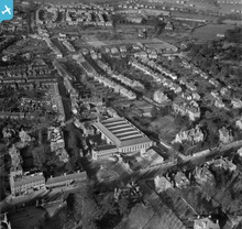
EAW003450 ENGLAND (1946). Bus depot at the junction of Grange Street and St Peter's Street and environs, St Albans, 1946

© Copyright OpenStreetMap contributors and licensed by the OpenStreetMap Foundation. 2026. Cartography is licensed as CC BY-SA.
Nearby Images (11)
EAW003450

EAW003452

EAW003449

EAW003451

EPW001252

EPW024300

EAW015578

EAW015579

EPW025389

EAW015580

EPW019238

Details
| Title | [EAW003450] Bus depot at the junction of Grange Street and St Peter's Street and environs, St Albans, 1946 |
| Reference | EAW003450 |
| Date | 18-December-1946 |
| Link | |
| Place name | ST ALBANS |
| Parish | |
| District | |
| Country | ENGLAND |
| Easting / Northing | 514975, 207845 |
| Longitude / Latitude | -0.33400246676706, 51.757022535897 |
| National Grid Reference | TL150078 |
Pins

Sparky |
Thursday 10th of August 2017 12:11:38 PM | |
|
Sparky |
Thursday 10th of August 2017 12:11:05 PM | |

John W |
Tuesday 2nd of August 2016 04:26:18 PM | |

Class31 |
Tuesday 3rd of September 2013 09:13:20 AM | |
|
Class31 |
Tuesday 3rd of September 2013 09:11:42 AM |
User Comment Contributions
1935 London Passenger Transport Board Omnibus Garage & Offices |
Class31 |
Sunday 8th of September 2013 09:33:35 PM |
As a bus buff I just love this photograph which shows the quality of the architecture employed by London Transport. For interest I attach a link to a page on the London Transport Museum's website which shows this location.http://www.ltmcollection.org/roundel/objects/object.html?_IXSR_=6hLrwDuKV9p&_IXMAXHITS_=1&IXsummary=section/section&IXinv=1998/87280&IXtype=archi&_IXFIRST_=12&_IXSESSION_=ksPA6xMdGkz |
Class31 |
Tuesday 3rd of September 2013 08:38:35 AM |