
WPW054627A WALES (1937) [Unlocated]
© Hawlfraint cyfranwyr OpenStreetMap a thrwyddedwyd gan yr OpenStreetMap Foundation. 2026. Trwyddedir y gartograffeg fel CC BY-SA.
Delweddau cyfagos (48)
EPW000143

EPW000667

EPW005260

EPW006389
, 1921")
EPW007181

EPW015853

EPW015854

EPW015855

EPW016012

EPW016510

EPW016641

EPW017028

EPW017029

EPW017136

SAW003585

SAW003586

SAW009337

SAW009800

SAW009801

SAW009802

SAW010734

SAW014737

SAW017926

SAW017927

SAW032504

SPW020275

SPW020280

SPW020281

SPW020284

SPW020632

SPW020633

SPW027083

SPW049776

SPW049777

SPW049779

SPW049783

SPW049791

SPW049798

SPW049801

SPW049827

SPW049828

SPW049831

SPW049832

SPW049834

SPW049948

SPW049949

SPW051009

SPW062638

Manylion
| Pennawd | WPW054627A |
| Cyfeirnod | WPW054627A |
| Dyddiad | 28-July-1937 |
| Dolen | |
| Enw lle | |
| Plwyf | |
| Ardal | |
| Gwlad | WALES |
| Dwyreiniad / Gogleddiad | 0, 0 |
| Hydred / Lledred | -7.556448482059, 49.766185796754 |
| Cyfeirnod Grid Cenedlaethol | SV000000 |
Pinnau
 |

Class31 |
Monday 12th of January 2015 07:56:56 AM |
|
Class31 |
Sunday 11th of January 2015 10:53:27 PM | |
|
Class31 |
Friday 10th of October 2014 04:46:37 PM | |

David Beilby |
Friday 14th of June 2013 06:20:38 PM | |
|
Class31 |
Wednesday 12th of June 2013 08:19:00 PM | |
|
Class31 |
Wednesday 12th of June 2013 08:18:41 PM | |
|
Class31 |
Wednesday 12th of June 2013 08:18:18 PM | |
|
Class31 |
Wednesday 12th of June 2013 08:15:00 PM | |
|
Class31 |
Wednesday 12th of June 2013 08:10:44 PM | |
|
Class31 |
Wednesday 12th of June 2013 08:09:50 PM | |
|
Class31 |
Wednesday 12th of June 2013 08:09:03 PM | |
|
Class31 |
Wednesday 12th of June 2013 08:08:43 PM | |
|
Class31 |
Wednesday 12th of June 2013 07:56:15 PM |


Cyfraniadau Grŵp
The incorrectly-numbered duplicate of this image has now been deleted. The contributions associated with it will also have been deleted. Please feel free to add your comments, pins and tags to this correct image. Yours, Jemima Britain from Above Web Admin Team |
Britain from Above |
Thursday 25th of September 2014 12:41:03 PM |
Eureka I am disappointed how long it took me to identify this one as I was annotating other photographs of this area earlier on today. I actually put a photo of the church at the middle left up on the site. I shall now attempt to do so again! |
Class31 |
Tuesday 2nd of July 2013 05:07:47 PM |
Thanks for confirming the location. It will take a little longer to make the necessary changes, starting with the negative on the shelf and working all the way through to the catalogue and online record. Yours, Katy Britain from Above Cataloguing Team Leader |
Katy Whitaker |
Tuesday 2nd of July 2013 05:07:47 PM |
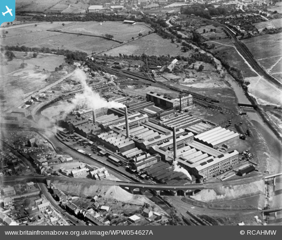
View is looking broadly east. |
Class31 |
Wednesday 12th of June 2013 08:19:53 PM |
This is Mond Nickel in Clydach in the Swansea Valley which is in Wales. |
Class31 |
Wednesday 12th of June 2013 07:49:56 PM |