
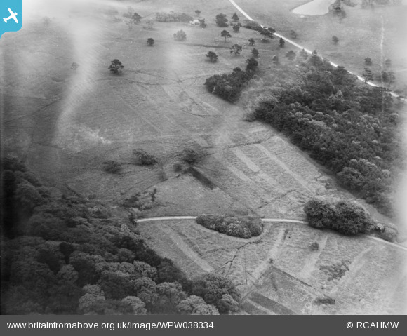
WPW038334 WALES (1932). View of part of Hensol Castle grounds, oblique aerial view. 5"x4" black and white glass plate negative.
© Hawlfraint cyfranwyr OpenStreetMap a thrwyddedwyd gan yr OpenStreetMap Foundation. 2026. Trwyddedir y gartograffeg fel CC BY-SA.
Manylion
| Pennawd | [WPW038334] View of part of Hensol Castle grounds, oblique aerial view. 5"x4" black and white glass plate negative. |
| Cyfeirnod | WPW038334 |
| Dyddiad | 1932 |
| Dolen | Coflein Archive Item 6370926 |
| Enw lle | |
| Plwyf | |
| Ardal | |
| Gwlad | WALES |
| Dwyreiniad / Gogleddiad | 304659, 178985 |
| Hydred / Lledred | -3.3737369173932, 51.50126709968 |
| Cyfeirnod Grid Cenedlaethol | ST047790 |
Pinnau
 |

Class31 |
Saturday 1st of August 2015 08:01:16 AM |
|
Class31 |
Monday 6th of January 2014 09:44:10 AM | |

Maurice |
Tuesday 20th of August 2013 08:11:33 AM | |
|
Maurice |
Tuesday 20th of August 2013 08:05:42 AM | |

Cabby |
Wednesday 13th of February 2013 01:03:25 AM | |
|
Cabby |
Wednesday 13th of February 2013 12:58:53 AM | |
|
Cabby |
Wednesday 13th of February 2013 12:58:14 AM | |
|
Class31 |
Wednesday 24th of October 2012 11:42:03 PM | |
Furzemill Pond |
Class31 |
Monday 6th of January 2014 09:46:47 AM |

SteveAUS |
Tuesday 3rd of July 2012 06:55:18 AM | |
These look like 'drives' or 'rides' cut through the grass or bracken. In the first case for shooting and the second for horse riding. ... but they seem to go nowhere which might suggest the first is more likely! |
Maurice |
Tuesday 20th of August 2013 08:07:53 AM |
Cyfraniadau Grŵp

New Pond and Home Plantation, Margam Park, 25/07/2015 |
Class31 |
Saturday 1st of August 2015 08:08:54 AM |

Looking south east towards Furzemill Pond, Margam Park, 25/07/2015 |
Class31 |
Saturday 1st of August 2015 07:57:39 AM |
I think that this could be in the Hensol Castle area. More work needed. |
Class31 |
Saturday 1st of August 2015 07:44:18 AM |
Subsequently found to be Margam Park |
Class31 |
Saturday 1st of August 2015 07:44:18 AM |
This is in the grounds of Margam Park and not Hensol Castle. The title will need to be changed. |
Class31 |
Tuesday 15th of July 2014 03:44:58 PM |
This is a photo taken looking south which are always more difficult to identify. I was looking in the Llantrisant area which was where a previous photo had been taken. I moved along to Margam Park when I had that Eureka moment by standing on my head, well almost. |
Class31 |
Monday 6th of January 2014 09:51:12 AM |
Eureka At last! Margam Park looking south over Home Plantation towards Furzemill Pond |
Class31 |
Monday 6th of January 2014 09:40:28 AM |
I am going to hazard a guess at this one as I believe it may be part of the grounds of Belton House near Grantham in Lincolnshire,not Wales as caption suggests.The road appears to be the (now) A607 looking towards Grantham at top of picture.The lake previously noted by class 31 could be the still extant water hazard at Belton Woods Hotel's (now)golf course(Google Earth seems to agree with this ref.distance from road).If I am right the marks in the grass are the "Ghosts" of barrack huts which were erected in WW1 as the grounds were the training school of the Machine Gun Corps-the programme "Time Team" has done a dig here very recently.The camp had it's own railway and the imprint of the trackbed could be the curvy line about 1/4 way down the picture.Could be quite wrong of course but this is definately a possibility. |
Cabby |
Wednesday 28th of August 2013 04:21:15 PM |
Very curvy for a railway trackbed. Look at the scale - it's more likely just a country track. |
Dave T |
Wednesday 28th of August 2013 04:21:15 PM |
Sorry Cabby but I can't find any evidence in the photo to link it with Belton Castle in Lincolnshire. I suggest that we are back to the drawing board. I have no idea of the correct location. |
Class31 |
Sunday 19th of May 2013 05:50:59 PM |