
WPW032473 WALES (1930) [Unlocated]
© Hawlfraint cyfranwyr OpenStreetMap a thrwyddedwyd gan yr OpenStreetMap Foundation. 2026. Trwyddedir y gartograffeg fel CC BY-SA.
Delweddau cyfagos (48)
EPW000143

EPW000667

EPW005260

EPW006389
, 1921")
EPW007181

EPW015853

EPW015854

EPW015855

EPW016012

EPW016510

EPW016641

EPW017028

EPW017029

EPW017136

SAW003585

SAW003586

SAW009337

SAW009800

SAW009801

SAW009802

SAW010734

SAW014737

SAW017926

SAW017927

SAW032504

SPW020275

SPW020280

SPW020281

SPW020284

SPW020632

SPW020633

SPW027083

SPW049776

SPW049777

SPW049779

SPW049783

SPW049791

SPW049798

SPW049801

SPW049827

SPW049828

SPW049831

SPW049832

SPW049834

SPW049948

SPW049949

SPW051009

SPW062638

Manylion
| Pennawd | WPW032473 |
| Cyfeirnod | WPW032473 |
| Dyddiad | June-1930 |
| Dolen | |
| Enw lle | |
| Plwyf | |
| Ardal | |
| Gwlad | WALES |
| Dwyreiniad / Gogleddiad | 0, 0 |
| Hydred / Lledred | -2.9546736215598, 51.609876990581 |
| Cyfeirnod Grid Cenedlaethol | ST339906 |
Pinnau

Col |
Sunday 26th of May 2024 08:06:49 PM | |
|
Col |
Sunday 26th of May 2024 08:05:46 PM | |
|
Col |
Tuesday 5th of January 2021 05:53:27 PM | |
|
AndyB |
Wednesday 5th of June 2013 10:02:03 AM | |
|
AndyB |
Wednesday 5th of June 2013 09:53:26 AM | |

Class31 |
Tuesday 15th of January 2013 11:25:11 PM | |
|
Class31 |
Saturday 5th of January 2013 02:42:47 PM | |
|
Class31 |
Friday 4th of January 2013 11:27:44 PM | |
|
Class31 |
Friday 4th of January 2013 11:17:46 PM | |
|
Class31 |
Friday 4th of January 2013 11:09:15 PM | |
|
Class31 |
Friday 4th of January 2013 11:05:47 PM | |
|
Class31 |
Friday 4th of January 2013 11:05:19 PM | |
|
Class31 |
Friday 4th of January 2013 11:02:38 PM | |
|
Class31 |
Friday 4th of January 2013 11:02:10 PM | |
|
Class31 |
Friday 4th of January 2013 10:54:46 PM | |
|
Class31 |
Friday 4th of January 2013 10:54:20 PM | |
|
Class31 |
Friday 4th of January 2013 10:53:44 PM | |
|
Class31 |
Friday 4th of January 2013 10:53:21 PM | |
|
Class31 |
Friday 4th of January 2013 10:45:46 PM | |
|
Class31 |
Friday 4th of January 2013 10:44:55 PM | |
|
Class31 |
Friday 4th of January 2013 10:40:35 PM | |
Went on a visit here today. Well worth visiting and walking round the adjoining Roman sites even on a chilly winter's day. |
Class31 |
Tuesday 15th of January 2013 11:21:37 PM |
|
TomRobin |
Tuesday 1st of January 2013 06:50:28 PM |
Cyfraniadau Grŵp
Thanks for working this one out! The original Aerofilms Ltd Register entry for the image is "East Ilsley". Now we know it's Caerleon. It will take a bit longer to put this right - we have to make changes to the original archive item (the glass plate) and other aspects of the record, but we are on the case and the necessary corrections will appear here in due course. Yours, Katy Britain from Above Cataloguing Team Leader |
Katy Whitaker |
Thursday 7th of March 2013 04:24:36 PM |
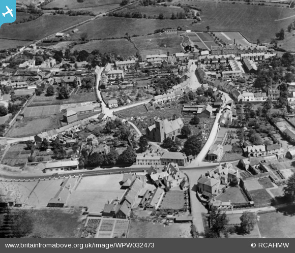
A view looking north east over St. Cadoc's Church in the centre of Caerleon. I was able to identify the Roman Legionary Museum which I have visited. I remembered the building in Caerleon but because the photo was allocated to England I discounted Caerleon and was looking for a look alike building in England. I should have looked at the obvious first. |
Class31 |
Friday 4th of January 2013 11:01:32 PM |
Eureka I should have gone with my instincts! I was put off by it being classified as England!!! |
Class31 |
Friday 4th of January 2013 10:32:43 PM |
A Berkshire village possibly - the next image ref is EPW032473 East Ilsley - see www.britainfromabove.org.uk/image/epw032474?search=EPW032474&ref=0 |
MB |
Saturday 15th of December 2012 11:47:29 AM |