
EPW058414 ENGLAND (1938) [Unlocated]. UNLOCATED. This image has been produced from a copy-negative.

© Hawlfraint cyfranwyr OpenStreetMap a thrwyddedwyd gan yr OpenStreetMap Foundation. 2026. Trwyddedir y gartograffeg fel CC BY-SA.
Delweddau cyfagos (48)
EPW000143

EPW000667

EPW005260

EPW006389
, 1921")
EPW007181

EPW015853

EPW015854

EPW015855

EPW016012

EPW016510

EPW016641

EPW017028

EPW017029

EPW017136

SAW003585

SAW003586

SAW009337

SAW009800

SAW009801

SAW009802

SAW010734

SAW014737

SAW017926

SAW017927

SAW032504

SPW020275

SPW020280

SPW020281

SPW020284

SPW020632

SPW020633

SPW027083

SPW049776

SPW049777

SPW049779

SPW049783

SPW049791

SPW049798

SPW049801

SPW049827

SPW049828

SPW049831

SPW049832

SPW049834

SPW049948

SPW049949

SPW051009

SPW062638

Manylion
| Pennawd | [EPW058414] UNLOCATED. This image has been produced from a copy-negative. |
| Cyfeirnod | EPW058414 |
| Dyddiad | 26-July-1938 |
| Dolen | |
| Enw lle | |
| Plwyf | |
| Ardal | |
| Gwlad | ENGLAND |
| Dwyreiniad / Gogleddiad | 0, 0 |
| Hydred / Lledred | -7.556448482059, 49.766185796754 |
| Cyfeirnod Grid Cenedlaethol | SV000000 |
Pinnau

TomRobin |
Thursday 13th of October 2016 10:39:23 PM | |
|
TomRobin |
Thursday 13th of October 2016 07:26:01 PM | |
|
TomRobin |
Sunday 2nd of November 2014 11:23:29 AM | |
and a change of topography, from irregular field pattern to more rectangular |
TomRobin |
Sunday 2nd of November 2014 11:25:19 AM |
Cyfraniadau Grŵp
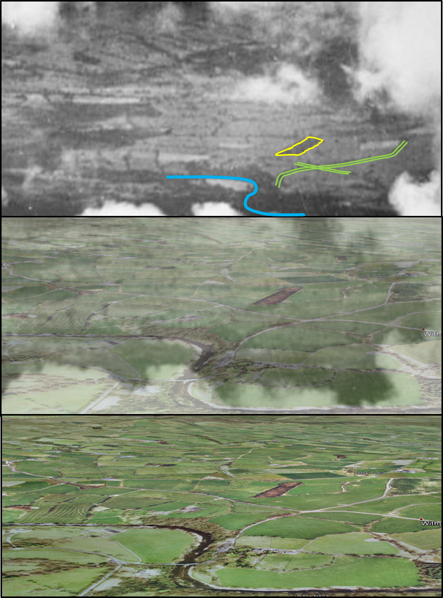
From the limited ground shown i think i've identified Moss Wood and a sweep of the river Hodder near Withgill, west of Clitheroe. I hope the attached pic illustrates this better - although i can't quite get a perfect match with Google Earth. |
nkingdon |
Sunday 5th of July 2015 11:31:39 PM |
A rural area with field boundaries. We do not know the orientation of the photo. |

Class31 |
Wednesday 3rd of December 2014 12:02:36 PM |
EPW058415 is one I located of Clouds over Longridge and Longridge Fell, Ribchester, 1938 taken on 26th July 1938 |
Class31 |
Monday 3rd of November 2014 09:55:54 AM |
EPW058413 is of St Mary's Church and the town centre, Uttoxeter, 1938 on 28th July 1938 |
Class31 |
Monday 3rd of November 2014 09:53:45 AM |
Next photo in sequence is in the Ribble Valley. Judging by the sun we are looking generally West |
TomRobin |
Sunday 2nd of November 2014 10:15:28 AM |