
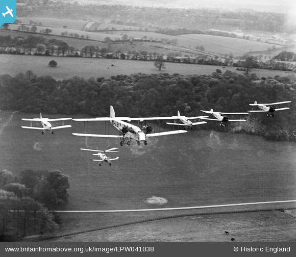
EPW041038 ENGLAND (1933). Woldingham, formation flying at the National Aviation Day air display, 1933
© Hawlfraint cyfranwyr OpenStreetMap a thrwyddedwyd gan yr OpenStreetMap Foundation. 2026. Trwyddedir y gartograffeg fel CC BY-SA.
Manylion
| Pennawd | [EPW041038] Woldingham, formation flying at the National Aviation Day air display, 1933 |
| Cyfeirnod | EPW041038 |
| Dyddiad | April-1933 |
| Dolen | |
| Enw lle | WOLDINGHAM |
| Plwyf | WOLDINGHAM |
| Ardal | |
| Gwlad | ENGLAND |
| Dwyreiniad / Gogleddiad | 535754, 156074 |
| Hydred / Lledred | -0.053038277822343, 51.287093332994 |
| Cyfeirnod Grid Cenedlaethol | TQ358561 |
Pinnau

BenR |
Sunday 22nd of December 2013 11:07:09 PM | |
|
Big John |
Tuesday 5th of November 2013 07:30:11 PM | |
|
Big John |
Tuesday 5th of November 2013 07:23:37 PM | |
|
Big John |
Tuesday 5th of November 2013 07:22:04 PM | |

Class31 |
Friday 1st of November 2013 09:12:27 PM | |
The Bushes |
Class31 |
Monday 18th of November 2013 08:47:56 AM |
|
Class31 |
Friday 1st of November 2013 09:11:57 PM | |
Now identified as the road leading south from Woldingham Station towards Woldingham School for Girls, Marden Park |
Class31 |
Monday 18th of November 2013 08:44:03 AM |
Cyfraniadau Grŵp
Thanks for all the comments and work on this image. I make it around about TQ35765608. We'll update the catalogue and post the new data here in due course. Yours, Katy Britain from Above Cataloguing Team Leader |
Katy Whitaker |
Monday 6th of January 2014 03:02:30 PM |
I believe this to be looking south west from a point above Beddlestead Farm near Warlingham. It is very difficult to identify much! |
Class31 |
Monday 18th of November 2013 08:41:04 AM |
Now identified as near Marden Park, Woldingham |
Class31 |
Monday 18th of November 2013 08:41:04 AM |
I am not 100% confident on this one because there is not much to enable identification. Can anyone help, please? |
Class31 |
Monday 18th of November 2013 08:39:52 AM |
I think you're spot on, Class31. Looking West. On Google Earth you can see the change in the angle of the fenceline just below the track in the foreground, and the trees in the bottom right corner of the photo are part of a shelter belt that runs E-W on either side of the road. You can also see the fence in the bottom right corner of the photo that joins the long fenceline. I make the long. and lat. refs on Google Earth for the intersection of the two fences in the bottom right corner as 51°18'3.35"N and 0° 0'6.17"E. (I don't have access to maps to give the grid refs, sorry). |
Rebecca |
Monday 4th of November 2013 02:54:05 PM |
Hello I think the photo is taken looking west over Marden Park in Woldingham. The road shown is the single track road accessing the present day Woldingham School, a Catholic boarding school. The view is from just south of Woldingham train station, looking west. In the far distance on the right of the picture is Caterham Valley, with the line of the Caterham bypass about 1/4 of the way down on the right. On Google Earth, they have a 1945 aerial composite of the area and you can very faintly see the fence line that skirts the tree clump on the left. On the 1945 image you can see a field that follows the right hand line of this fence. To the left of the furthest left plane you can see where a footpath enters the treeline. This is visible on Google Earth too. |
Big John |
Tuesday 5th of November 2013 07:20:18 PM |
Hi Rebecca and Big John Following your comments I've just had a look at this area and I'm pretty confident that Big John has located this photograph. Everything fits for the location between Marden Park and Woldingham Station. Well done Big John |
Class31 |
Monday 18th of November 2013 08:39:52 AM |
Planes flying: G-ABVY, G-ACCX, G-???? Tiger Moth number not visible, G-ABYX and another with number unclear (possibly G-ABVH) with rotor plane (possibly G-ABUC) underneath. Seem too be flying in same formation as EPW041037 and EPW041039 ie taken on same flight? |
Rebecca |
Friday 1st of November 2013 04:33:12 PM |