
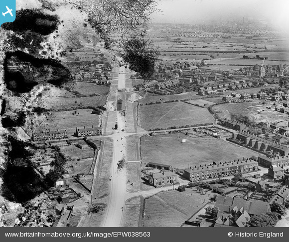
EPW038563 ENGLAND (1932). The East Lancashire Road (A580) under construction, Moorside, from the north-west, 1932. This image has been produced from a damaged negative.
© Hawlfraint cyfranwyr OpenStreetMap a thrwyddedwyd gan yr OpenStreetMap Foundation. 2026. Trwyddedir y gartograffeg fel CC BY-SA.
Manylion
| Pennawd | [EPW038563] The East Lancashire Road (A580) under construction, Moorside, from the north-west, 1932. This image has been produced from a damaged negative. |
| Cyfeirnod | EPW038563 |
| Dyddiad | June-1932 |
| Dolen | |
| Enw lle | MOORSIDE |
| Plwyf | |
| Ardal | |
| Gwlad | ENGLAND |
| Dwyreiniad / Gogleddiad | 376644, 401252 |
| Hydred / Lledred | -2.3521990376519, 53.507187989344 |
| Cyfeirnod Grid Cenedlaethol | SD766013 |
Pinnau

IanRoeGreener |
Thursday 19th of June 2025 04:14:39 PM | |
|
IanRoeGreener |
Thursday 19th of June 2025 03:53:36 PM | |
|
Moonraker |
Friday 10th of November 2023 04:43:31 PM | |
|
Moonraker |
Friday 10th of November 2023 04:33:25 PM | |
|
Moonraker |
Friday 10th of November 2023 04:31:45 PM | |

Ubik360 |
Sunday 16th of May 2021 09:04:33 AM | |
|
Ubik360 |
Sunday 16th of May 2021 09:01:38 AM | |
|
Ubik360 |
Sunday 16th of May 2021 09:00:14 AM | |
|
tagg747 |
Sunday 19th of April 2020 03:27:20 PM | |
|
Martin |
Sunday 25th of May 2014 09:49:46 PM | |
|
Andy_S |
Sunday 25th of May 2014 09:30:32 PM |