
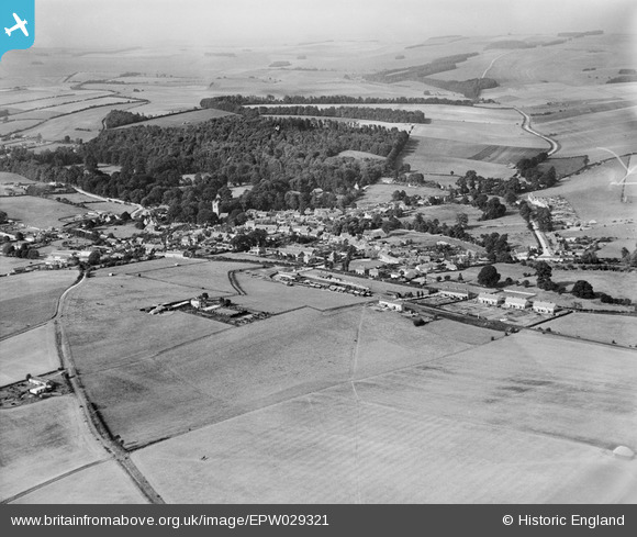
EPW029321 ENGLAND (1929). The village, Lambourn, from the south-east, 1929
© Hawlfraint cyfranwyr OpenStreetMap a thrwyddedwyd gan yr OpenStreetMap Foundation. 2026. Trwyddedir y gartograffeg fel CC BY-SA.
Manylion
| Pennawd | [EPW029321] The village, Lambourn, from the south-east, 1929 |
| Cyfeirnod | EPW029321 |
| Dyddiad | September-1929 |
| Dolen | |
| Enw lle | LAMBOURN |
| Plwyf | LAMBOURN |
| Ardal | |
| Gwlad | ENGLAND |
| Dwyreiniad / Gogleddiad | 432783, 178306 |
| Hydred / Lledred | -1.5276393349694, 51.502254643206 |
| Cyfeirnod Grid Cenedlaethol | SU328783 |
Pinnau
Byddwch y cyntaf i ychwanegu sylw at y ddelwedd hon!
Cyfraniadau Grŵp
A wonderful picture of tranquillity and an unspoilt Lambourn. Not even Lambourn school on the hill at that time, but showing the beautiful railway station that we had and even Lockmeadow Cottages just across the railway line. A rare picture indeed. That's when Lambourn was a lovely village. |

Mick Dowdeswell |
Thursday 27th of October 2016 08:26:47 PM |
I agree, although I barely remember the cottages even though I was born in one of them I was trying to find out which one but my birth certificate only says Lockmeadows. We then moved to Walkers Lane aproximatley when I was three. I left in 1950. |
Fenner |
Thursday 27th of October 2016 08:26:47 PM |
This picture of the railway station shows the original, extended engine shed and the siding behind the signal box. BBoth were removed soon after this was taken. Also shown are the |GWR horse boxes which were a must at Lambourn. |
Ian B |
Friday 20th of November 2015 08:18:02 PM |