
EPW028590 ENGLAND (1929) [Unlocated]. UNLOCATED
© Hawlfraint cyfranwyr OpenStreetMap a thrwyddedwyd gan yr OpenStreetMap Foundation. 2026. Trwyddedir y gartograffeg fel CC BY-SA.
Delweddau cyfagos (48)
EPW000143

EPW000667

EPW005260

EPW006389
, 1921")
EPW007181

EPW015853

EPW015854

EPW015855

EPW016012

EPW016510

EPW016641

EPW017028

EPW017029

EPW017136

SAW003585

SAW003586

SAW009337

SAW009800

SAW009801

SAW009802

SAW010734

SAW014737

SAW017926

SAW017927

SAW032504

SPW020275

SPW020280

SPW020281

SPW020284

SPW020632

SPW020633

SPW027083

SPW049776

SPW049777

SPW049779

SPW049783

SPW049791

SPW049798

SPW049801

SPW049827

SPW049828

SPW049831

SPW049832

SPW049834

SPW049948

SPW049949

SPW051009

SPW062638

Manylion
| Pennawd | [EPW028590] UNLOCATED |
| Cyfeirnod | EPW028590 |
| Dyddiad | August-1929 |
| Dolen | |
| Enw lle | |
| Plwyf | |
| Ardal | |
| Gwlad | ENGLAND |
| Dwyreiniad / Gogleddiad | 0, 0 |
| Hydred / Lledred | -7.556448482059, 49.766185796754 |
| Cyfeirnod Grid Cenedlaethol | SV000000 |
Pinnau

Triggy |
Saturday 22nd of February 2014 02:36:51 PM | |
|
boltie |
Friday 27th of December 2013 10:28:49 AM | |

Jon |
Sunday 18th of November 2012 07:51:23 PM |
Cyfraniadau Grŵp
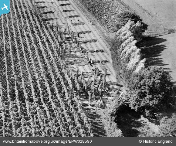
Hop harvest, so I reckon it's likely to be in Kent somewhere |
Rebecca |
Friday 20th of December 2013 03:25:36 PM |
There are plenty of hops grown in Worcestershire and Herefordshire too. |
emu-star |
Friday 20th of December 2013 03:25:36 PM |
Yes this is a Hop field, as 'hopping' is in progress this would be taken in August |
coullone |
Saturday 31st of August 2013 10:49:53 AM |
A hop-field, so possibly Kent |
TomRobin |
Sunday 21st of October 2012 06:53:22 PM |
I'll guess that this is hop picking. |

Class31 |
Friday 19th of October 2012 01:10:00 AM |