
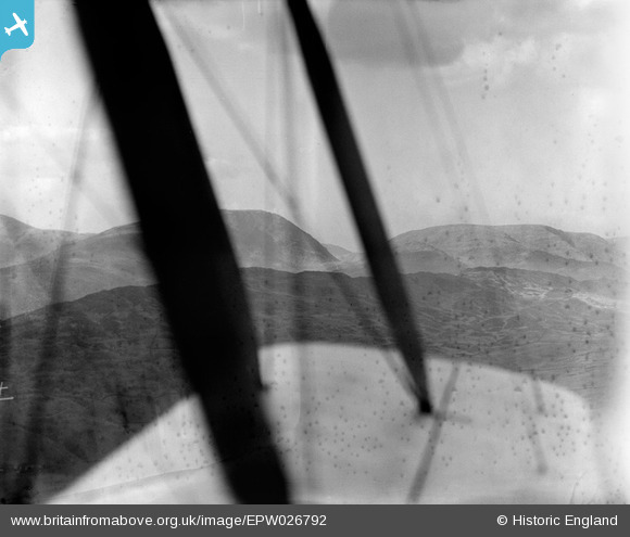
EPW026792 ENGLAND (1929). Red Screes and the Kirkstone Pass viewed through the aircraft wing over The Hundreds, Ambleside, from the south, 1929
© Hawlfraint cyfranwyr OpenStreetMap a thrwyddedwyd gan yr OpenStreetMap Foundation. 2026. Trwyddedir y gartograffeg fel CC BY-SA.
Manylion
| Pennawd | [EPW026792] Red Screes and the Kirkstone Pass viewed through the aircraft wing over The Hundreds, Ambleside, from the south, 1929 |
| Cyfeirnod | EPW026792 |
| Dyddiad | May-1929 |
| Dolen | |
| Enw lle | AMBLESIDE |
| Plwyf | LAKES |
| Ardal | |
| Gwlad | ENGLAND |
| Dwyreiniad / Gogleddiad | 340133, 504066 |
| Hydred / Lledred | -2.9229108422808, 54.428351576101 |
| Cyfeirnod Grid Cenedlaethol | NY401041 |
Pinnau
Cyfraniadau Grŵp
How about this being taken from somewhere near the National Park centre at Brockhole on Windermere, in a Northerly direction. Wansfell is in the forground, Red Screes is the high point in the centre with the Kirkstone pass to the right of it. |

JEM |
Wednesday 8th of January 2014 09:27:27 AM |
Hi JEM I think that you might be right! I have dug out my A Wainwright A Pictorial Guide to the Lakeland Fells Book 2 The Far Eastern Fells. In the entry for Wansfell page 7 there is a sketch of Red Screes from the summit of Wansfell which looks very similar to our photograph. On the Wansfell page 6 in the same publication is a view from the summit northwards towards Kirkstone Pass and Caudale Moor where the mountains have a profile similar to that in our photograph. |

Class31 |
Wednesday 11th of December 2013 08:44:22 PM |
Hi JEM, Thanks for the suggestion! We'll update the catalogue and post the new data here in due course. Yours, Katy Britain from Above Cataloguing Team Leader |
Katy Whitaker |
Wednesday 8th of January 2014 09:27:27 AM |
there is a very good photo by Joe Jackson showing the same viewpoint at http://www.lakedistrict-walks.co.uk/Wainwrights/Wansfell.html |
TomRobin |
Saturday 14th of December 2013 01:19:26 AM |
Can't fault that spot well done |
Dave Brunt |
Saturday 14th of December 2013 01:19:26 AM |
I shall put a flag on Loughrigg but I am far from certain with this identification. Can anyone else help please? |
Class31 |
Tuesday 3rd of September 2013 03:17:18 PM |
Hi Class31, Sorry to say I'm far from convinced...although I have nothing better to offer. Yours, Katy Britain from Above Cataloguing Team Leader |
Katy Whitaker |
Tuesday 3rd of September 2013 03:17:18 PM |
The foreground has all of the characteristics of Loughrigg Fell. I shall investigate further tomorrow. |
Class31 |
Friday 5th of July 2013 10:56:34 PM |
Is this the same location as EPW026796? |
Class31 |
Friday 5th of July 2013 10:14:29 PM |
Could be from position 54°36'30.57" N 3°20'59.52" W heading about 150 deg. towards Grasmoor/Crummock Water, Cumbria, although by no means sure. |
deannajoseph |
Tuesday 28th of May 2013 02:45:41 PM |
Sorry. I thought it was the Lune Gorge but then decided it wasn't. |
Class31 |
Friday 26th of October 2012 11:10:06 PM |