
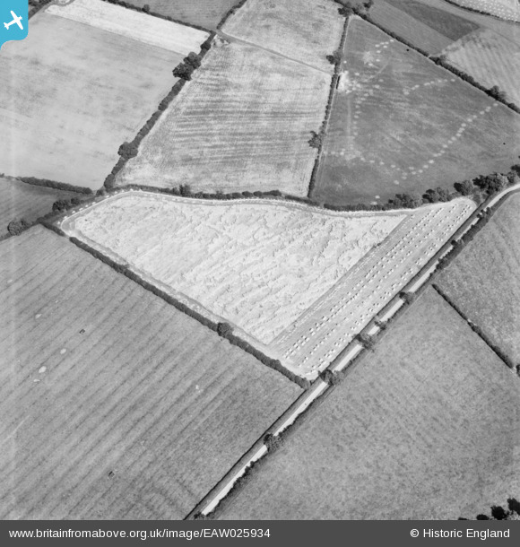
EAW025934 ENGLAND (1949). Lodged and harvested cereal crops, Illston on the Hill, 1949
© Hawlfraint cyfranwyr OpenStreetMap a thrwyddedwyd gan yr OpenStreetMap Foundation. 2026. Trwyddedir y gartograffeg fel CC BY-SA.
Manylion
| Pennawd | [EAW025934] Lodged and harvested cereal crops, Illston on the Hill, 1949 |
| Cyfeirnod | EAW025934 |
| Dyddiad | 15-August-1949 |
| Dolen | |
| Enw lle | ILLSTON ON THE HILL |
| Plwyf | ILLSTON ON THE HILL |
| Ardal | |
| Gwlad | ENGLAND |
| Dwyreiniad / Gogleddiad | 471436, 299305 |
| Hydred / Lledred | -0.94547359065168, 52.586493906027 |
| Cyfeirnod Grid Cenedlaethol | SP714993 |
Pinnau
 |

K9-Q |
Tuesday 1st of December 2015 08:29:16 PM |

Class31 |
Sunday 23rd of February 2014 05:52:03 PM | |
|
Peter |
Thursday 20th of February 2014 07:25:10 PM | |

melgibbs |
Monday 30th of December 2013 06:14:48 PM | |
theo the crop has blown over in the wind the tractor is pulling a reaper binder a ealey type of harvester that cut the wheat straw so it fell upon a canvas belt that rolled and tied the sheff and deposited it for standing in ricks in the field this cut the need for farm workers with synths as only one man was needed to cut and bind the crop |
K9-Q |
Tuesday 1st of December 2015 07:58:24 PM |
Cyfraniadau Grŵp
I've had a good look at the area to the south of Whitehouse Farm and south east of Smalley Wood and the generally triangular shaped field in the photo does not match the one I can see on the 1938 1:10560 OS map of the area. In particular there is no road down one of the straight boundary sides. The field boundaries in adjoining fields do not match those on the OS map. Of course there is the possibility that I am looking at the wrong field but on balance I don't believe that we have the correct location this time. |
Class31 |
Tuesday 1st of December 2015 08:36:39 PM |
Ok Stupid error caused by a) staying up too late and b) allowing myself to be distracted. Now I've GOT to find it. |

Dylan Moore |
Friday 21st of February 2014 10:59:52 PM |
Hi Dylan Don't beat yourself up about it. You found quite a few and gave me the leads to find another three. Good work for us both! |
Class31 |
Sunday 23rd of February 2014 06:11:22 PM |
https://goo.gl/maps/GF8rp5bYBmG2 you may need to rotate map but field layout is still the same 2014 |
K9-Q |
Tuesday 1st of December 2015 08:36:39 PM |
Thanks for taking the trouble to stick at it! We'll update the catalogue and post the new data here in due course. Yours, Katy Britain from Above Cataloguing Team Leader |
Katy Whitaker |
Thursday 6th of March 2014 12:12:05 PM |
View is looking east |
Class31 |
Sunday 23rd of February 2014 05:53:53 PM |
Eureka |
Class31 |
Sunday 23rd of February 2014 05:50:55 PM |
Fields between Smalley and Stanley Common. The boundaries appear on the pre-war map, but are now mostly gone. |
Dylan Moore |
Thursday 20th of February 2014 10:23:14 PM |
EAW025927 is of opencast workings at Smalley. See EAW025928 EAW025929 EAW025931 EAW025932 EAW025933 EAW025930 |
TomRobin |
Thursday 2nd of January 2014 06:22:41 PM |