
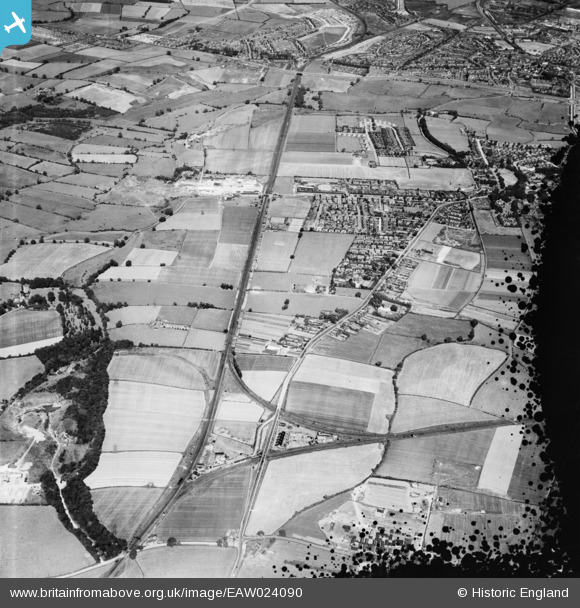
EAW024090 ENGLAND (1949). Norton West Railway Junction and the residential area surrounding Junction Road, Stockton-on-Tees, 1949. This image has been produced from a damaged negative.
© Hawlfraint cyfranwyr OpenStreetMap a thrwyddedwyd gan yr OpenStreetMap Foundation. 2026. Trwyddedir y gartograffeg fel CC BY-SA.
Manylion
| Pennawd | [EAW024090] Norton West Railway Junction and the residential area surrounding Junction Road, Stockton-on-Tees, 1949. This image has been produced from a damaged negative. |
| Cyfeirnod | EAW024090 |
| Dyddiad | 22-June-1949 |
| Dolen | |
| Enw lle | STOCKTON-ON-TEES |
| Plwyf | |
| Ardal | |
| Gwlad | ENGLAND |
| Dwyreiniad / Gogleddiad | 443473, 522462 |
| Hydred / Lledred | -1.3270846091384, 54.595348646889 |
| Cyfeirnod Grid Cenedlaethol | NZ435225 |
Pinnau

Matt Aldred edob.mattaldred.com |
Monday 11th of May 2026 04:27:54 PM | |

J May |
Tuesday 24th of February 2026 03:15:50 PM | |
|
J May |
Tuesday 24th of February 2026 03:10:39 PM | |
|
J May |
Monday 4th of November 2024 01:29:06 PM | |
|
Tricky11 |
Tuesday 26th of September 2023 02:17:41 PM | |
|
PinzaC55 |
Sunday 11th of September 2022 11:08:12 PM | |
|
PinzaC55 |
Sunday 11th of September 2022 11:06:16 PM | |
|
J May |
Wednesday 27th of July 2022 05:43:19 PM | |
|
D |
Monday 27th of June 2022 05:58:43 PM | |
|
D |
Monday 27th of June 2022 05:55:34 PM | |
|
npwooks |
Saturday 6th of February 2021 06:04:18 PM | |
|
J May |
Thursday 21st of January 2021 03:10:16 PM | |
|
J May |
Thursday 21st of January 2021 03:09:22 PM | |
|
J May |
Thursday 21st of January 2021 03:06:36 PM | |
|
J May |
Friday 3rd of January 2020 01:15:16 PM | |
|
J May |
Friday 3rd of January 2020 01:13:37 PM | |
|
J May |
Friday 3rd of January 2020 01:12:36 PM | |
|
J May |
Friday 3rd of January 2020 01:12:20 PM | |
|
trevorsboy |
Saturday 19th of March 2016 04:36:29 PM | |
|
Paul S |
Friday 9th of October 2015 01:41:39 AM | |
|
Paul S |
Friday 9th of October 2015 01:40:14 AM | |
|
J May |
Thursday 29th of January 2015 02:37:18 PM | |
|
Fantasma |
Sunday 16th of February 2014 02:30:15 PM | |
|
Fantasma |
Sunday 16th of February 2014 02:28:58 PM | |
|
Fantasma |
Saturday 15th of February 2014 09:49:19 PM | |
|
Fantasma |
Saturday 15th of February 2014 09:45:57 PM | |
|
Fantasma |
Saturday 15th of February 2014 09:44:04 PM | |
|
Fantasma |
Saturday 15th of February 2014 09:38:39 PM | |
https://picturestocktonarchive.com/2014/09/26/the-stockton-stone-and-concrete-company/ |
J May |
Thursday 2nd of December 2021 02:14:11 PM |
|
Fantasma |
Saturday 15th of February 2014 08:52:09 PM | |
|
Fantasma |
Saturday 15th of February 2014 08:50:09 PM | |
This end of the railway line is shown in a little more detail on image EAW024101. |
Fantasma |
Monday 24th of March 2014 09:12:55 PM |
|
Fantasma |
Saturday 15th of February 2014 08:48:29 PM | |
This end of the line is shown in a little more detail on image EAW024101. |
Fantasma |
Sunday 23rd of March 2014 09:54:08 AM |
|
Fantasma |
Saturday 15th of February 2014 08:46:46 PM | |
|
Fantasma |
Saturday 15th of February 2014 08:44:59 PM | |
|
Fantasma |
Saturday 15th of February 2014 08:44:09 PM | |
|
Fantasma |
Saturday 15th of February 2014 08:42:44 PM | |
|
Fantasma |
Saturday 15th of February 2014 05:33:05 PM | |
|
Fantasma |
Saturday 15th of February 2014 05:24:42 PM | |
|
J May |
Wednesday 22nd of January 2014 02:04:30 PM | |
|
J May |
Wednesday 22nd of January 2014 01:57:37 PM | |
The guns were 4.7 inch calibre weapons, the largest type of anti-aircraft guns in use by British forces at the time with a range of 32,000 feet -that is six miles high |
J May |
Wednesday 22nd of January 2014 11:15:28 PM |
|
J May |
Wednesday 22nd of January 2014 01:30:00 PM | |
|
J May |
Saturday 11th of January 2014 10:00:04 PM | |
|
J May |
Saturday 11th of January 2014 09:59:12 PM | |
|
J May |
Saturday 11th of January 2014 09:57:57 PM | |
|
J May |
Saturday 11th of January 2014 09:56:26 PM | |
|
J May |
Saturday 11th of January 2014 09:55:15 PM | |
|
J May |
Saturday 11th of January 2014 09:50:30 PM | |
|
J May |
Saturday 11th of January 2014 09:50:07 PM | |
also sometimes known as "the back line". |
Fantasma |
Saturday 15th of February 2014 05:26:15 PM |
Where did this go to? |
paulc924 |
Saturday 11th of July 2015 11:18:22 PM |
|
J May |
Saturday 11th of January 2014 09:49:36 PM | |
|
J May |
Saturday 11th of January 2014 09:49:11 PM | |
|
J May |
Saturday 11th of January 2014 09:48:36 PM | |
|
J May |
Saturday 11th of January 2014 09:40:05 PM | |
|
J May |
Saturday 11th of January 2014 09:32:10 PM |

Cyfraniadau Grŵp
Calf Fallow Lane |
D |
Monday 6th of July 2015 04:33:20 PM |