
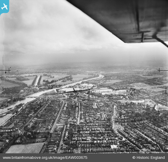
EAW003675 ENGLAND (1947). The River Thames in flood, East Molesey, from the west, 1947
© Hawlfraint cyfranwyr OpenStreetMap a thrwyddedwyd gan yr OpenStreetMap Foundation. 2026. Trwyddedir y gartograffeg fel CC BY-SA.
Manylion
| Pennawd | [EAW003675] The River Thames in flood, East Molesey, from the west, 1947 |
| Cyfeirnod | EAW003675 |
| Dyddiad | 18-March-1947 |
| Dolen | |
| Enw lle | EAST MOLESEY |
| Plwyf | |
| Ardal | |
| Gwlad | ENGLAND |
| Dwyreiniad / Gogleddiad | 514648, 168229 |
| Hydred / Lledred | -0.35167481385259, 51.400995942923 |
| Cyfeirnod Grid Cenedlaethol | TQ146682 |
Pinnau

wessexpig |
Wednesday 18th of June 2014 08:18:21 PM | |
|
Gone2Kent |
Wednesday 18th of June 2014 05:42:03 PM | |
|
Gone2Kent |
Wednesday 18th of June 2014 05:41:59 PM | |
|
Stuart |
Wednesday 18th of June 2014 08:36:14 AM |
Cyfraniadau Grŵp
I remember the floods in 1947. It had been a long cold winter and the rivers flooded when the snow thawed. I lived in Esher Road. Tbe water didn't come in the house but the road was flooded. The local council provided a lorry to ferry people through the water. |
Sheena |
Tuesday 17th of June 2014 09:30:52 PM |