
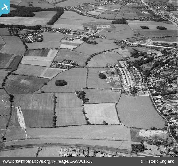
EAW001610 ENGLAND (1946). Grafton Drive and environs including Upton Army Camp, Upton, 1946
© Hawlfraint cyfranwyr OpenStreetMap a thrwyddedwyd gan yr OpenStreetMap Foundation. 2026. Trwyddedir y gartograffeg fel CC BY-SA.
Manylion
| Pennawd | [EAW001610] Grafton Drive and environs including Upton Army Camp, Upton, 1946 |
| Cyfeirnod | EAW001610 |
| Dyddiad | 11-July-1946 |
| Dolen | |
| Enw lle | UPTON |
| Plwyf | |
| Ardal | |
| Gwlad | ENGLAND |
| Dwyreiniad / Gogleddiad | 327616, 387801 |
| Hydred / Lledred | -3.0883297323533, 53.381827911078 |
| Cyfeirnod Grid Cenedlaethol | SJ276878 |
Pinnau
 ORDNANCE DEPOT: e79289 (Removed) ORDNANCE DEPOT: e79289 (Removed) |

Matt Aldred edob.mattaldred.com |
Thursday 8th of May 2025 03:44:04 PM |
| Possible WW2 Pillbox: e79287 |
Matt Aldred edob.mattaldred.com |
Thursday 8th of May 2025 02:33:50 PM |
| Upton Army Camp |

flagermus |
Tuesday 24th of January 2023 12:41:55 PM |
| Upton Railway Station |
John W |
Friday 15th of May 2020 11:41:56 AM |
| Excavator |

Sparky |
Friday 22nd of September 2017 06:33:31 PM |
This was digging a drain for the estate grids to the Fender. It was above ground and visible when I was a kid. We actaully (stupidly) crawled up from the Fender and arrived below the grid in front of our house 26 Orrets Meadow. Amazing what we did as kids |
Phil |
Saturday 8th of February 2025 07:53:49 PM |
| Mavis Drive |
lmccu81 |
Saturday 7th of November 2015 03:03:35 PM |
| Arrowe House Farm |
lmccu81 |
Saturday 7th of November 2015 03:02:01 PM |
| St. Mary's Church |
lmccu81 |
Saturday 7th of November 2015 02:53:04 PM |
| Upton library |
lmccu81 |
Saturday 7th of November 2015 02:51:01 PM |
| Upton library |
lmccu81 |
Saturday 7th of November 2015 02:50:57 PM |
| The Allotments |
Roger Reid |
Monday 6th of October 2014 05:17:04 PM |
| Woodchurch Estate |
Roger Reid |
Monday 6th of October 2014 05:15:35 PM |