
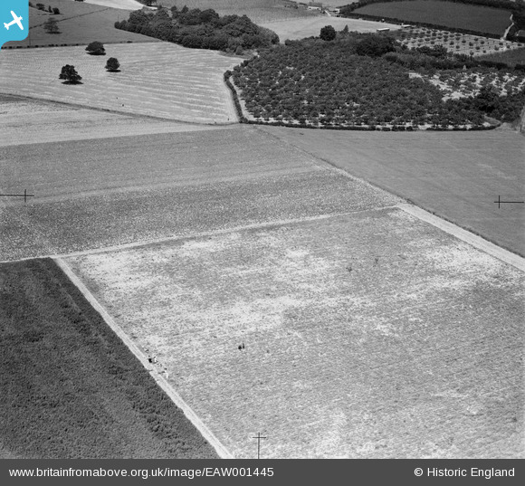
EAW001445 ENGLAND (1946). Farmland at Spitzbrook, Collier Street, 1946
© Hawlfraint cyfranwyr OpenStreetMap a thrwyddedwyd gan yr OpenStreetMap Foundation. 2026. Trwyddedir y gartograffeg fel CC BY-SA.
Manylion
| Pennawd | [EAW001445] Farmland at Spitzbrook, Collier Street, 1946 |
| Cyfeirnod | EAW001445 |
| Dyddiad | 3-July-1946 |
| Dolen | |
| Enw lle | COLLIER STREET |
| Plwyf | COLLIER STREET |
| Ardal | |
| Gwlad | ENGLAND |
| Dwyreiniad / Gogleddiad | 572165, 146918 |
| Hydred / Lledred | 0.46429583307353, 51.194988330202 |
| Cyfeirnod Grid Cenedlaethol | TQ722469 |
Pinnau

Class31 |
Friday 22nd of November 2013 01:00:23 PM | |
|
Class31 |
Thursday 19th of September 2013 11:26:24 PM | |
They can indeed but not where I had originally thought! |
Class31 |
Friday 22nd of November 2013 01:37:43 PM |
|
Class31 |
Thursday 19th of September 2013 11:25:18 PM | |
|
Class31 |
Thursday 19th of September 2013 11:15:59 PM | |
|
Class31 |
Wednesday 18th of September 2013 03:03:05 PM |
Cyfraniadau Grŵp
I think this could be Dens Farm 1/2 mile from EAW001446 see 1955 map there is an orchard of correct shape near a wood and a house by a track. grid ref 716 475 |

TomRobin |
Monday 6th of January 2014 04:05:01 PM |
corrected grid ref is 721 470 |
TomRobin |
Wednesday 27th of November 2013 12:14:31 AM |
Thanks for going to so much trouble with this image. We'll update the catalogue and post the new data here in due course. Yours, Katy Britain from Above Cataloguing Team Leader |
Katy Whitaker |
Monday 6th of January 2014 04:05:01 PM |
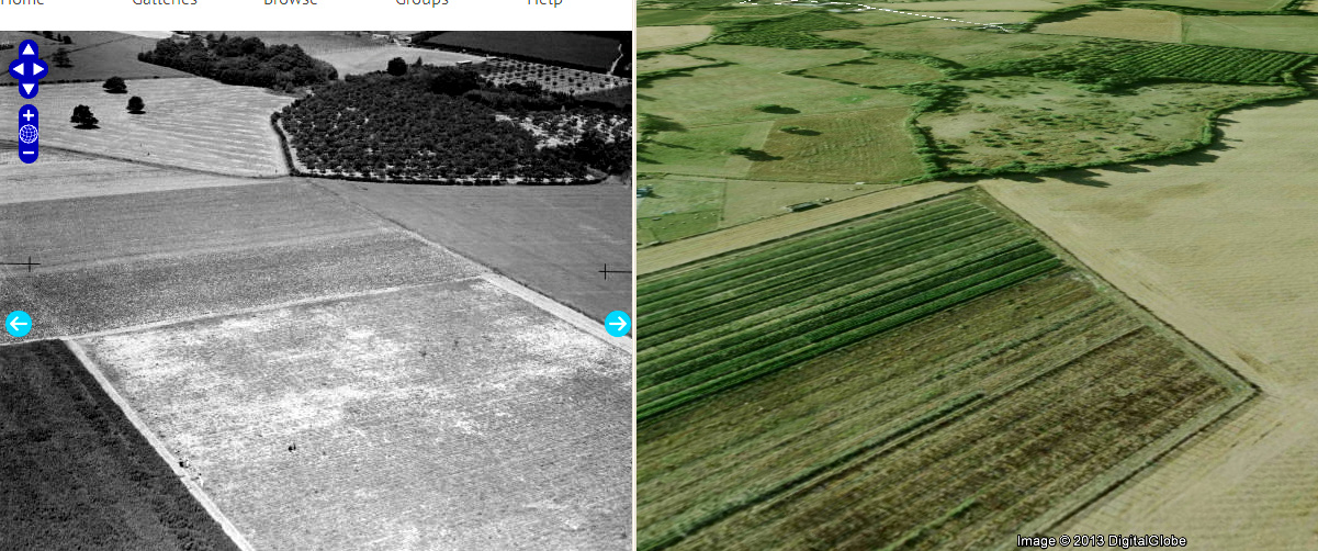
I hope no ones thinks me too pedantic, but i'd move the location grid reference 740m to the south west to put the near corner of the orchard at 572081,147014? Its between Den Cottages (top of original photo) and Spitzbrook Lodge just off the left side. Looking to the NW, I've used a 2003 old GoogleEarth image as its clearer (but wider a angle). |
nkingdon |
Tuesday 26th of November 2013 11:51:51 PM |
This older image makes it much clearer. location was my fault, I was looking at the other photo from the North when I set it. |
TomRobin |
Tuesday 26th of November 2013 11:29:32 PM |
Wow the similarity is striking. Great stuff! |
Class31 |
Tuesday 26th of November 2013 11:51:51 PM |
I am far from convinced on this one but I believe it could be where I have indicated. a. It fits with the location of adjacent photos b. The field boundaries tend to fit. c. The Ordnance Survey for those photos in this area which I have identified is not overly helpful. d. It seemed practice to change the ground use. e. The field boundaries are weak and not well defined by hedges. |
Class31 |
Friday 22nd of November 2013 01:46:39 PM |
Unless I'm looking in the wrong place (I've found Baybrooks and Mill Lane), I'm not seeing this one at all. |
Tony D |
Sunday 22nd of September 2013 12:33:13 PM |
I was trying to defend the indefensible! |
Class31 |
Friday 22nd of November 2013 01:46:39 PM |
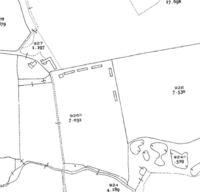
Revised position slightly. This is Den Cottages, the orchards are to the SouthEast. The new orchard in the photo still exist. the featured orchard shape is partially visible especially the sharp corner, at the southern point, only a few trees left. The sheds are clearly shown on the 1938 field maps |
TomRobin |
Friday 22nd of November 2013 01:44:55 PM |
Well done TomRobin on this one. Everything fits. The cottage is the same, the field boundaries match. You have it. |
Class31 |
Friday 22nd of November 2013 01:44:55 PM |
presumably somewhere between "Meopham Green" EAW001444 on previous photo and "Mockbeggar" on the next EAW001446 |
TomRobin |
Tuesday 19th of November 2013 06:34:51 PM |
Hullo, I'm afraid I can't make this fit - the buildings on "Mill Lane" aren't working for me, and the details of the field shapes and watercourses in that immediate area don't work. The original Register entry is no help at all, bar confirming the county (Kent). Yours, Katy Britain from Above Cataloguing Team Leader |
Katy Whitaker |
Saturday 2nd of November 2013 07:07:55 PM |
I agree that my case on this one is weak and that more work is needed to establish the correct locations of this pair of photos. It is likely to be in the Horsmonden area. From the work I have already done in this area I know that the field boundaries are not well defined and that land use has varied over time. Is anyone reading this who might be able to add anything to the debate? |
Class31 |
Saturday 2nd of November 2013 07:07:55 PM |
The best way to look at this is on Google Earth where the field shapes may be seen today. The Ordnance Survey maps of the period are less helpful. I know from the other Horsmonden pictures that the landscape in the area changes markedly over the years. I find it fascinating that there are three largish trees which look to be there today and are in the old picture. On the other hand I may be reading too much into this and trying to get it to fit! I would love to be able to see the area by walking the ground but it is a little too far away. |
Class31 |
Wednesday 25th of September 2013 03:04:38 PM |
Bing maps also looks a reasonable fit to what is shown in the photograph. |
Class31 |
Friday 20th of September 2013 11:29:55 AM |
I think that I know where this is but proving it will be the difficult part. If my hypothesis is correct the Ordnance Survey maps are not too helpful. I shall have to gather the evidence. I think that this is near Horsmonden just south of a farm called Baybrooks. We are looking west. |
Class31 |
Thursday 19th of September 2013 11:10:19 PM |