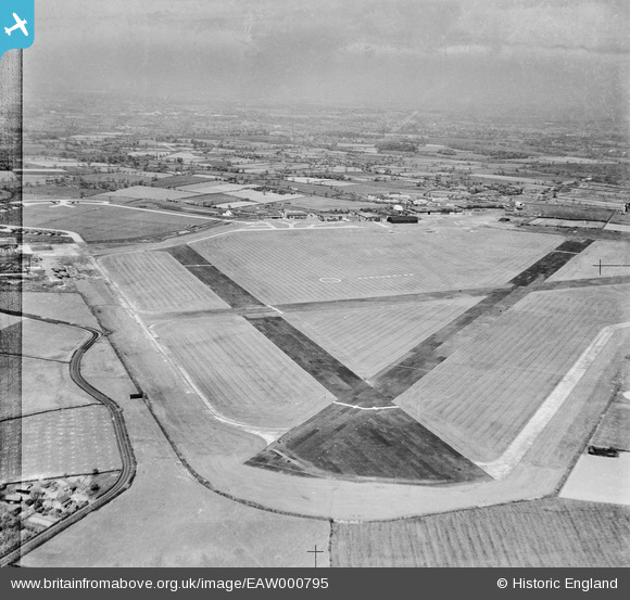
EAW000795 ENGLAND (1946). RAF Ringway, Castle Hill, from the south-west, 1946

© Hawlfraint cyfranwyr OpenStreetMap a thrwyddedwyd gan yr OpenStreetMap Foundation. 2025. Trwyddedir y gartograffeg fel CC BY-SA.

Manylion

Pennawd [EAW000795] RAF Ringway, Castle Hill, from the south-west, 1946
Cyfeirnod EAW000795
Dyddiad 12-May-1946
Dolen
Enw lle CASTLE HILL
Plwyf RINGWAY
Ardal
Gwlad ENGLAND
Dwyreiniad / Gogleddiad 381542, 384010
Hydred / Lledred -2.2773295318295, 53.352386465144
Cyfeirnod Grid Cenedlaethol SJ815840

Pinnau

Ringway Road, towards Moss Nook and Styal

John Ellis
Monday 12th of January 2015 05:41:40 PM
Outwood Lane

John Ellis
Monday 12th of January 2015 05:40:50 PM
Woodhouse Farm

John Ellis
Monday 12th of January 2015 05:39:56 PM
Outwood Lane, Ringway

John Ellis
Sunday 11th of January 2015 06:01:59 PM
Signal Square

IanL
Sunday 25th of May 2014 10:23:45 PM
Yew Tree Lane

IanL
Sunday 25th of May 2014 10:12:27 PM
Hangar No7 (formerly No5 during wartime when used by Parachute Training School) - remained in use until the construction of Terminal 3 in 1996.

IanL
Sunday 25th of May 2014 10:08:56 PM
Hangar No6 (formerly No4 during wartime when used by Parachute Training School) - remained in use until the construction of Terminal 3 in 1996.

IanL
Sunday 25th of May 2014 10:08:12 PM
Additional hangar erected during WWII for the use of the Parachute Training School

IanL
Sunday 25th of May 2014 10:07:20 PM
Hangar No3 - 1939 Bellman hangar used by the Parachute Training School during WWII

IanL
Sunday 25th of May 2014 10:06:33 PM
Hangar No2 - 1939 Bellman hangar used by the Air Transport Auxillary

IanL
Sunday 25th of May 2014 10:05:47 PM
Hangar No1 built as part of the 1938 terminal by Manchester Corporation.

IanL
Sunday 25th of May 2014 10:05:02 PM
Original 1938 terminal apron

IanL
Sunday 25th of May 2014 10:01:50 PM
1938 Terminal Building and Control Tower

IanL
Sunday 25th of May 2014 10:00:44 PM
Southern taxiway providing access to/from runways 06 and 02 from the Avro hangars.

IanL
Sunday 25th of May 2014 09:57:07 PM
Runway 10/28 - with displaced thresholds this provided about 3000ft for operations. The runway remained in use for light aircraft up to the late 1970s. It is now disused with sections remaining in use as taxiway and light aircraft parking

IanL
Sunday 25th of May 2014 09:55:48 PM
Runway 02/20 - the displaced thresholds gave about 3000ft of available runway for operations. This runway remained in use till the late 1970s for light aircraft. With the expansion of the airport and the creation of Terminal 2 the runway was taken out of use and what remains forms parts of Taxiway A and C and a light aircraft parking area.

IanL
Sunday 25th of May 2014 09:54:53 PM
Runway 24/06 - 4,200ft long at this time. Still in use today, albeit significantly longer to 3048m (10,000ft) x 45m (147ft) wide. Due to magnetic variation the runway designation is now 23R/05L

IanL
Sunday 25th of May 2014 09:54:05 PM
Northern aircraft dispersal area - appears to be a number of Halifax bombers awaiting conversion to freighters and paratroop transports in 1946. This area is now part of the Terminal 2 and Cargo Centre apron.

IanL
Sunday 25th of May 2014 09:52:22 PM
Fairey Aviation Hangar complex - was used from 1936 till 1977 by the company. At the time of this photograph the facility was being used for the conversion of Handley Page Halifax bombers into freight and paratroop transports. Just to the North you can see a number of aircraft on the dispersal and a further two Halifax bombers parked outside the large hangar.

IanL
Sunday 25th of May 2014 09:51:33 PM

IanL
Sunday 25th of May 2014 09:50:03 PM
If I read the picture right and this is the A538 Altrincham-Wilmslow road, it's Wilmslow Road - the name changes at the Ringway/Hale border, near the junction with Hasty Lane.

John Ellis
Wednesday 14th of January 2015 10:24:23 AM