Grwpiau
London's East End
About the group A group for old cockneys
Wedi ei greu 25 June 2012
|
Gawd, Luv a Duck ... Saw me Mums Washing on the Line in the 1940s
|

Time Traveller |
|
|
Hi I am trying to contact anyone who worked at the Trebor factory at Woodford Bridge
|

Dee |
|
|
a e Symes Ltd.
|
sue64 |
|
|
Hi I am looking for anyone that worked for A E Symes LTd in the coop at Stratford especially in the boiler rooms up until 1962 my dad jack was a apprentice painter this is very important please
|
sue64 |
|
|
Good day. Have just started browsing this site after finding it many months ago. I was born in Essex in an Isolation hospital for TB patients and shipped back to Millwall where I lived with my dad and Grandparents. Moved to Poplar aged six and then to Goodmayes age 18. Went to school in Poplar and Stepney and completed an apprenticeship in the Royal Docks before going to sea as Junior Engineer. Now living in North Tyneside.
Do I qualify to join this group? Am quite Familiar with the East End history so if you have any questions will be more than happy to answer them if I can. Regards, George |
Grollo |
|
|
George, Welcome to the group. I have not visited the site for a number of weeks so I missed your original comment.
I think the main qualification for joining the group is an interest in East London so you are most welcome. I also saw your other comment about the West India Dock. On leaving school n 1959 I started my working life as a telegram boy at Poplar so I knew the docks well. By co-incidence I also finished my working life there when the Control Room for the London Fire Brigade was moved to the Millwall Dock. I did not recognise the area at first due to the amount of demolition and rebuilding that has taken place. |

Historian |
|
|
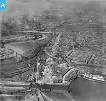
The very office I am sitting in as I type this is built near the bottom of this photo in what was then the north dock. It is very different today with only about a fifth at most of the dock remaining. Th rest of the dock has been filled in over the last 20 years and built on, most recently by the cross rail development.
|
ResearchAddict |
|
|
Not so much a reply to the comment but an observstion of the image. Concidering the number of ships in the dock there is very little cargo being handled. When I checked the period 1921 the world in general was in the grip of a great depression. This image sums it up as almost all the ships appear laid up. Those tied up to buoys off the quays for certain. This is only a small section of the enclosed docks and the number of men (dockers) out off work must have been enormous. Apart from them it must have been a hard time in general.
|
Grollo |
|
|
I was born in Forest Gate in 1950 and am researching my family history in Poplar and Limehouse.
|
eastendgirl |
|
|
I can just make out Holy Trinity church, Barking Road. Closed 1948 then demolished.
|
Where's Canning Town? |
|
|
Hi, I've just found this site and can't wait to explore. My family history is English silk (orris) weavers in Bethnal Green, the City and Hackney. My great-grandfather's house was in Mortimer Road opposite where the Hackney mole man lived (though not quite the same time). My father's parents lived in Wadham Avenue, Walthamstow, and their garden backed onto the London Hospital Sports Ground. As a London child, I'd never seen such a huge green space! I've done a lot of family history research and my dream is to find a photo of my great-grandfather. So, if you have a photo of Walter Appleby (b1844 Bethnal Green, d1921 Hackney Union) please let me know!
|
sharpsecret |
|
|
AlanW |
|
|
Alan, is your site the Cordy House one?
|

Tony Quinlan |
|
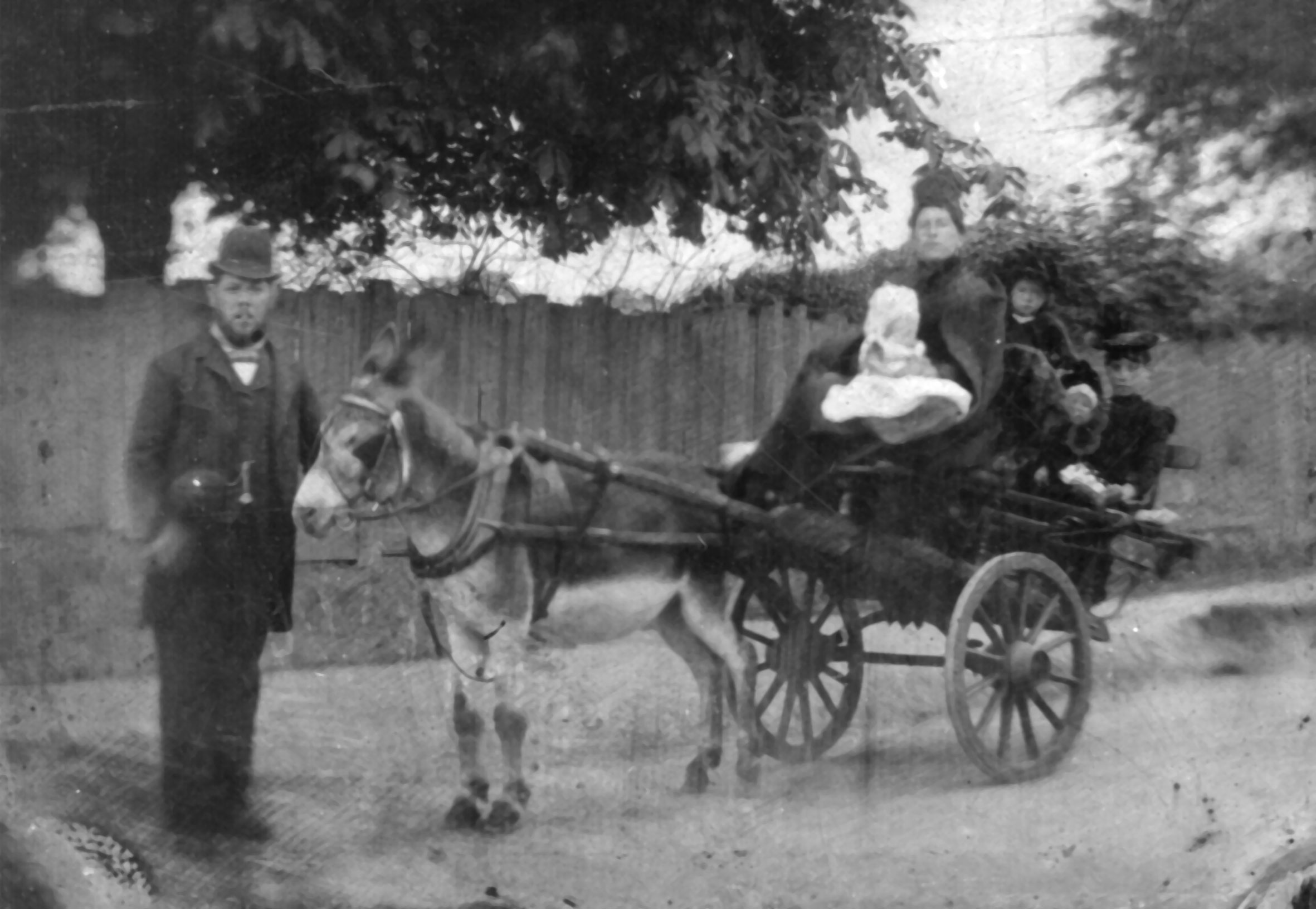
The accompanying picture (I scanned it from the original tintype)shows my great grandfather (Richard Callf), family and de luxe family transport outside of Victoria Park was taken towards the end of 19th century. My maternal grandmother is the eldest of the girls. The youngest child and the only boy is commemorated on the Menin Gate at Ypres. |
Patron |
|
|
What a great pic.....I'd love to know what my great grandfather looked like but never will.
Excellent donkey too. :-) |
Tony Quinlan |
|
|
Hi all, I was born in Walthamstow in 1954, all my family were from Walthamstow, and some still live there! I attended Walthamstow High School for Girls, as it was then, and worked initially in Woolworths at the bottom end of the market, and later at Tesco, at the top! I remember the Bonner's fruit and veg stall, Menzie's pie and mash shop with the live eel stall outside, and I can still 'smell' sarsparilla whenever I think of it....I've never seen it sold anywhere else!I remember that I learned to ballroom dance to the Bay City Rollers and Middle of the Road at Court school of dancing, but a lot of place names elude me now....I'm sure I must have done other stuff!
|

joybeddows |
|
|
Cornwell school just visible along with the gasholder in Manor park E12 top left of photo.
|
Skelly |
|
|
I have been trying to find which photograph you are referring to. I am assuming it's probably one of the Ilford aerial pictures with Manor Park in the background but I cannot determine which one it is.
|
Historian |
|
|
Great Site, looking forward to seeing more pics in the Manor Park E12 area.
|
Skelly |
|
|
On the home page of this site, this group is listed as the one with the most contibutions.
Well done people! :-) |
Tony Quinlan |
|
|
Antonia, Welcome to the group. I am curious of your link between Oxford and London's East End. Seemingly like a chalk and cheese match but I am certain it goes much deeper than that.
|
Historian |
|
|
I have just found this site and this group. I was born in Walthamstow in 1952 and still live in Chingford, about 5 minutes from Chingford Mount Cemetery. I have a postcard somewhere of the billet roundabout taken in the 60's. When I find it I will upload it I loved the trolley buses, going along Forest Road and past Rathbournes Dairy and the library. I went to Chapel End School in Walthamstow and did my engineering apprentiship at Fuller Elelctric in Fulbourne Road
|
Chingdevil |
|
|
Welcome to the board ChingDevil. 1952 is when I first family moved to Walthamstow with my family. Although I now live in Somerset, I normally visit Chingford Mount Cemetery about 3 or 4 times a year. I certainly remember the Old Crooked Billet Roundabout and although it was busy, I always felt safe on it. Now it seems to be traffic wizzing in all directions.
I also remember the North Circular Road, the part that goes towards Edmonton. It was the only road in Walthamstow, and the Woodford New Road I think that had no speed limit. There was no upper speed limit before the 70mph was introduced and technically it was possible to legally drive at 150mph or more. However most vehicles at the time were incapable to reaching more than about 60mph if that. |
Historian |
|
The old Crooked Billet roundabout in all it's glory.
|
Tony Quinlan |
|
|
I found a series of "movies" on London's East End on Youtube. Some are collages of pictures, others are movies. The last one on the list is old street trades in London, not necessarily the East End. However, the film is so evocative it is well worth the look.
http://tinyurl.com/9lrpgle http://www.youtube.com/watch?v=Z2LWBUcQz1c http://www.youtube.com/watch?v=bqJQiQPp-sY http://www.youtube.com/watch?v=3XvpdQu384A http://www.youtube.com/watch?v=GmJhVeB7ClM http://www.youtube.com/watch?v=BUGyxb1Kcp8 http://www.youtube.com/watch?v=T7INGCp6zRk http://www.youtube.com/watch?v=2p-B-3rNymg http://www.youtube.com/watch?v=smXKyg0Qk0g http://www.youtube.com/watch?v=5B4IfpFDFVE http://www.youtube.com/watch?v=LOVMF9_tzzE |
Historian |
|
|
Members to the group might be interested in a website I found by chance. It covers a verbal memory history of Walthamstow with many excellent pictures of Walthamstow, Leyton and Chingford I have never seen before. Most pictures are about late 1950's, early 1960's.
https://sites.google.com/site/playitagainsamclub/page-twelve---gone-but-not-quite-forgotten |
Historian |
|
|
The website url to the above was too long to be displayed in the text box. The shortened version is below.
http://tinyurl.com/95fae2e |
Historian |
|
|
So many places I remember, so many places long gone...
|
ResearchAddict |
|
|
Fantastic site...great find!
I loved it as I spent many years living in Walthamstow and Highams Park. |
Tony Quinlan |
|
|
Tony Quinlan |
|
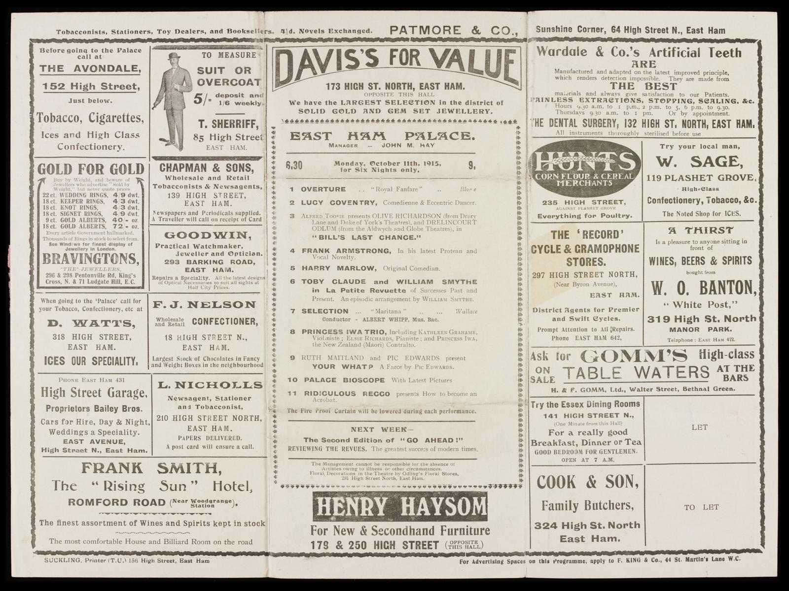
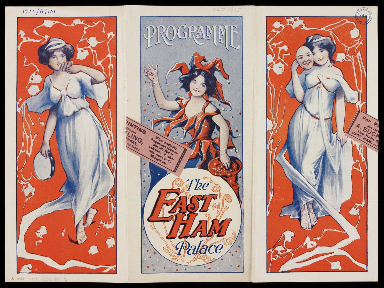
And here's the ads from the back of the programme.
All from 1915. |
Tony Quinlan |
|
|
That’s a lovely programme cover Tony, with a vaguely art nouveau - Alphone Mucha look to it.
According to the theatretrust.org.uk website East Ham Palace was demolished in 1958 and replaced by a featureless brick box which appears to have lasted longer on the site than the Palace did. |
ResearchAddict |
|
|
Interesting web site and book on the history of the great Eastend sweet manufactures, Trebor.
www.thetreborstory.com As well as being a frequent consumer of their products, Trebor House, the firm's headquarters from 1956, was located on Woodford Avenue at the end of my school playing field. |
ResearchAddict |
|
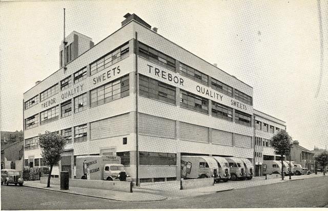
I went to Shaftsbury school in Forest Gate and the Trebor factory in Kathrine road was next door.
Their chimney towered above our playground. The lovely smells from there used to drive us kids insane all day. |
Tony Quinlan |
|
|
Being born just after the war, I was one of that generation of children denied sweets due to sugar rationing that continued for some years. I was seven years old when my mother gave me a tube of "Refreshers" made by Trebor which I took to school unopened to proudly show to my classmate who sat next to me on a double bench type desk. My teacher saw me showing this unopened tube of Refreshers and promptly confiscated them. This left me fuming as it meant I still had never tasted a sweet in my life. I told my mother about this when I went home for dinner, (we call it lunch now), and during afternoon classes, the classroom door burst open as my mother unexpectedly marched in and demand my sweets back. My teacher who was normally something of a martinet meekly handed them over and my mother promptly left. I was expecting terrible retribution from my teacher but not another word was ever said, presumably because she was fearful of another visit from my mother.
Later in life when I first left school I became a telegram boy on a motorbike based at Telephone House in Forest Gate. When I first passed Trebors not knowing at the time it was located in Katherine Road, the memory of my tube of Refreshers and my teacher came flooding back. |
Historian |
|
|
The Stratford area has changed dramatically over the last 30 years, even before the olympics!
Hidden behind the RTs and RTLs this chap captured some nice views of Stratford and Maryland in the late 60s: http://www.flickr.com/photos/david_christie/sets/72157625548683592/with/5869000240/ Newham Council has some nice image galleries on line as well: http://www.newhamstory.com/image/tid/1322 |
ResearchAddict |
|
|
Alternatively, just go to Flickr.com and put Davis Christie's name in the search box....I love his portfolio.
|
Tony Quinlan |
|
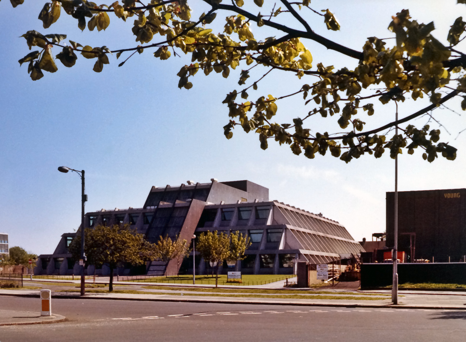
This photo was taken circa 1980. Originally intended to be Newham Council’s new office complex, cost cutting and delays meant that not only was this the only part to actually be built in 1976 but sub-standard building materials resulted in the concrete rotting after only a few years and it was demolished in 1998. My father was part of the design team in the late 60s and I used to regularly visit him in Newham architects office when this was on the drawing boards, it was certainly a lot more interesting than the usual schools and social housing he worked on. I have inherited a number of the original plans and artist impressions for it. It may not have been the best piece of architecture but at least it was interesting which is more than be said for much of the balnd modern boxes that have been put up in the area since then. |
ResearchAddict |
|
|
It does appear that the speed of change is accelerating. I recall this same site when it was the medical offices of West Ham Borough Council, then your photo which I think was nicknamed the pyramid and now a supermarket. Who knows what is next.
This site does appear to have difficulties in displaying long URL's, hence part of your Flickr URL has been lost. Although you probably know the answer, one way to overcome this problem is to visit a site like http://tinyurl.com/ By pasting a long URL into a box, it coverts it into a small URL which a site like this can then cope with. |
Historian |
|
|
How about this for a superb shot of Romford Market complete with animal pens then chaps?
|
Tony Quinlan |
|
|
This picture certainly brings back memories. As children our mother occasionally took us on a day trips to Southend which involved getting on a Green Line bus at the Bell Corner, Walthamstow. The route of the bus was along the Eastern Avenue but it detoured into Romford Market via North Street. On some occasions it was market day with stalls everywhere.
It may be hard to appreciate now but in the 1950's Romford was still considered a small country town. As London expanded it simply became engulfed by the expansion of Greater London in the same way the growth of East London engulfed smaller villages. It's quite surprising but if one look on Google Earth, with the exception of a five mile gap between Upminster and Basildon, the blur on the map caused by buildings runs continuously between Slough and Shoebury. Along the line of the Thames there is no building gap at all. It does make one wonder if within a few years, Southend and Shoebury will not be considered the new East London. |
Historian |
|
|
For those not familiar with the pioneering colour silent films by Claude Friese-Greene here is a clip of Petticoat Lane in the mid 1920s
http://www.youtube.com/watch?v=vzeBDcmrjjY&feature=share This is an extract from the BFI DVD 'The Open Road', a 60 minute colour travelogue of Britain taken between 1924-26 which I thoroughly recommend. The restored footage of a lost world brings the past well and truely to life and the DVD concludes with about 10 minutes of various views of London including London Bridge, the approach to Tower Bridge and Petticoat Lane. |
ResearchAddict |
|
|
Fantastic colour footage of Petticoat Lane there.
|
Tony Quinlan |
|
|
This link is absolutely wonderful for London nostalgia merchants like us by the way http://www.ltmcollection.org/films/index.html
|
Tony Quinlan |
|
|
What a great clip of Petticoat Lane, it almost makes one feel like your there.
|
Historian |
|
|
I was born in 1937 in London..but not in the east end..but in the slums of South Kensington(The great Depression)and my first job when leaving school was as a van boy for Saxa Salt in Dalston(Ridley Road)..spent the next three years delivering wide and far in the East End of London, from Silver Town Way and the Commercial Road and the Docks of London.Warren and Reynolds to the Tooley Street in Bermondsey and ate at Solly Isak's ell pie and mash stalls.Drank a pint at the Blind Beggar and remember Jack the Hat McVitie,as he was pointed out to me by my driver...
|

Peter the Poet |
|
|
The phrase "The slums of South Kensington" just doesn't sound right today does it!
|
Tony Quinlan |
|

Eleven of the sixteen members of the group haven't even posted! Come on, don't be shy! |
Tony Quinlan |
|
Great idea mate! |
Tony Quinlan |
|
|
Although it is likely that aerial photography for historical East London will be limited, it is still possible to see historical aerial imagery for the whole of East London using Google Earth. For anyone who may not be aware, by clicking on a icon that looks like a clock when using Google Earth, a slider bar graduated in years appears at the top of the map.
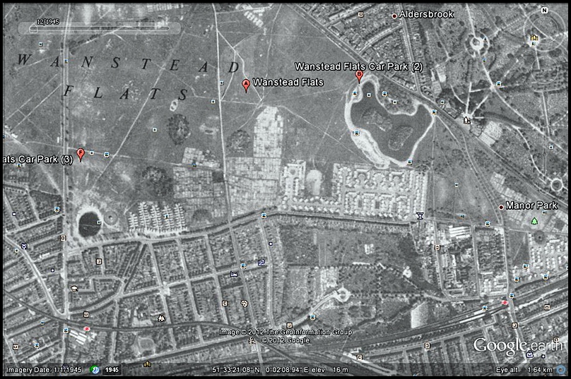
It is possible to set the slider bar back to 1945 and a ghostly grey aerial image of that period will appear and overlay the existing map. It should be appreciated that the image is low resolution but is still useful in determining old road layouts and even some buildings. The image can also be zoomed within the limits of low-res photography. If I use Wanstead Flats as an example, it is possible to see the layout of the postwar prefab estate that was built there but has long since gone. Wartime military camps and supply depots can also be seen including what may be the sites of anti-aircraft gun emplacements. Many cargo ships can also be seen in the docks as can the factories which used to line the riverside in Silvertown. Despite the low resolution, it is a useful tool which I often use. |
Historian |
|
|
You are right mate....I was shown that slider about a year ago and have had great fun with it.
Strange you should mention the prefabs at Wanstead Flats....I grew up in Manor Park and spent many happy hours on that estate in the prefabs of schoolmates who lived there. It was opposite the Golden Fleece pub and as you say, you see it clearly on Google Earth when you slide to 1945. Let's see if we can upload some screenshots from it to this place. :-) |
Tony Quinlan |
|
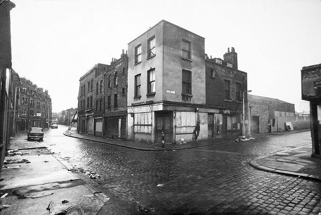
Taken in January 1973. At the very top of the road is Petticoat Lane of course. |
Tony Quinlan |
|
|
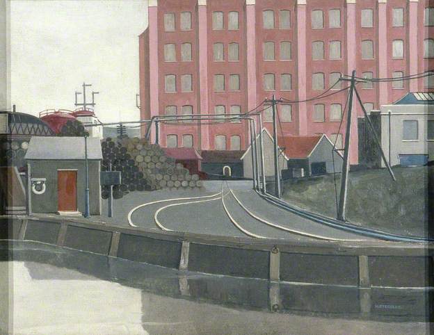
This is an evocatively nostalgic picture with wet cobblestones and derelict shops coupled with a sense of forlorn decay. Even the wooden truss shoring up a building further along the road emphasises the abandonment of what was once a thriving thoroughfare. I did look this road up and Google maps to find many of the buildings are still there following refurbishment as well as new building replacing that which presumably cound not be saved. I personaly see no problems with non-aerial photographs as presumably the East End was one of the least desirable areas at the time to aerial photographers albeit rich in diverse communities and life.
I find this photograph tells a powerful visual story. |
Historian |
|
|
This is a wonderful photo, redolent of the dirt and delapidation that seemed to sum up much of London at that time.
|
ResearchAddict |
|
|
On Monday night, 9th July at 9pm, the Yesterday Channel (12) is showing a program the ancient history of the Olympic site. I presume this will cover the Lea Valley. It's being presented by Tony Robinson which makes me tend to think the programme will probably flit around abit and the detail of any history might be limited. Never-the-less, it might be worth watching if anyone is interested.
|
Historian |
|
|
Thanks for the heads up mate....I think you may be right.
|
Tony Quinlan |
|
|
For anyone who may not have seen it, there is a video on UTube entitled East End Trolleys. It is a film about trolley buses and most scenes were shot between Walthamstow and the Woolwich Ferry via Stratford although other locations in Newham are also shown. From the clothes of passers-by and cars I would think it was probably filmed about the late 1950's possibly early 1960's.
The link is http://www.youtube.com/watch?v=ejnRrN3QhgE |
Historian |
|
|
Many thanks for this link, it’s an excellent find. I for one will have hours of fun trying to spot all the locations :-)
The most modern vehicle I could spot is what appears to be a Austin A60 Cambridge at 8’18’’ so that particular clip must be 1959-62. |
ResearchAddict |
|
|
At 48 seconds we are in Green Street Forest Gate with Henderson Road on the right and the junction with Romford Road around 120 yards ahead.
|
Tony Quinlan |
|
|
Knowing both Walthamstow and Newham very well, I recognise all the locations on that film. The list is too long to place here but if wishes to know a location I will do my best to advise. The best way to identify a particular clip of the film is to mention the time frame as Tony has already done.
|
Historian |
|
|
At the start it pans across Bishopsgate goods yard and station, which were still in use at the time this was shot. It lay derelict for years until 2004 when most of it was demolished. I believe the ornamental gate however survives (the white structure on the left at 0:13), it was cetainly still there looking very sorry for itself a few years back.
|
ResearchAddict |
|
|
Did any of you in this fine group watch The secret history of our streets? it was such a shame that the East end wasn't covered. I'm hoping that they do another series. I've everything crossed they do!!!!!! Hope you are all OK.Take care BP
|
blissfullpics |
|
|
I did watch this series and although as you say it did not cover the East End, two of the location, Deptford High Street and Camberwell Grove I know quite well and which I personally found of special interest. The series made great use of Booth's Poverty Map of London comparing his original colour/class classifications to how they are now. I have seen a copy of Booth's map for East London and although I cannot recall any particular street, there was a lot of what he deemed the Vivious or semi-criminal class.
One thing the programme did not directly mention but which was there as a clear undertrend, is how regeneration of an area does not normally benefit the poorer elements of society already living their. The process of regentrification be it by public of private money tends to attract the more affluent elements of society whom in turn displace the poorer elements. This has happened so many times, the Isle of Dogs, Islington to name but a few. It does appear to me that is exactly what is happening in Stratford now which as a result regeneration due to Olympics has clearly come under the spotlight. The newly incoming affluent or moderately affluent are pushing the less fortunate out. |
Historian |
|
|
I assume we've all see this......if you haven't, do so, it's wonderful stuff
http://www.bbc.co.uk/iplayer/episode/b01k7m4h/London_on_Film_The_East_End/ |
Tony Quinlan |
|
|
I’ve recorded but yet to view it.
If people are not aware there is a whole London season of archive and new programmes on iPlayer: http://www.bbc.co.uk/bbcfour/collections/p00synd3/london I think ‘Georgia Brown: Who Are the Cockneys Now?’ will be of particular interest to us here. http://www.bbc.co.uk/programmes/p00t3mkz Georgia Brown looks back to the Jewish east end that no longer existed when the programme was made back in 1968. Fascinating footage of the crumbling east end of 1968 which now also a thing of the past. Even more interesting are Georgia’s comment and observations for the future of the area which are remarkably prescient when viewed from 2012. |
ResearchAddict |
|
|
Tony, I did watch this programme when it was screened about one week ago. Although I thought the content was very good, by focusing almost exclusively around the Whitechapel area, it did show the mind set of what the producers thought was the East End when the film was originally made.
As we all know, Whitechapel was the first building block of todays modern East End and following the mid 1800's, the East End rapidly spread to include the villages of Stepney and Bow, (mentioned in the Pickwick Papers), before exploding into what was then parts of Essex. Areas like Newham, Hackney and Waltham Forest are completely overlooked. That should not distract from the quality of this programme but I have always had the feeling that even today, to non-East Enders, even those living in other parts of London, the East End of London is still something of an enigmatic mystery, something of the unknown, something to be feared. |
Historian |
|
|
I watched with great interest.I found that it wasn't on long enough and the great East End could of easily filled an hour long programme.Hope you are OK.Take care BP
|
blissfullpics |
|
|
The Tate and Lyle sugar refinery in Silvertown. The refinery is still there though little of the structure in this photo appears to have survived. The large chimney near the river remained until the 1970's and the light coloured building between it and the river is still there, though submerged under a lot of modern additions. Some more may still remain but hidden under the blue steel cladding of the modern refinery.
|
ResearchAddict |
|
|
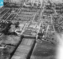
I originally went to Dulwich Village Infants School for a few months before moving to Leyton where I went first to Church Road Infants School and then Church Road Junior School next door. I have highlighted them both in the photograph of the London Electric Wire Company. The schools have now changed their names to Willow Brook. After two years my family moved to Walthamstow and I continued at Greenleaf Junior School and then William McGuffie Secondary Modern School in Greenleaf Road. Wiliam McGuffie School had a local nickname of "Scruffy McGuffie". Most pupils including myself did not wear the school uniform as it was too expensive. I do not recall if the school had a motto but I often felt it should have been "Survive".
|
Historian |
|
|
Tony,
My school - Beal in Woodford Bridge Road - also took us swimming in the icy cold waters of Valentines Park open air pool; cold even in the Summer! Otherwise we went to the Ilford Baths near to Seven Kings. There were two pools - the larger one was covered over in the Winter and used for indoor bowles - Saturday evenings they had wrestling, Jackie Palllo, Big Daddy and all the people we saw on Saturday afternoon telly. I do not think I will forget the `demure` ladies who could have been our mums screaming and yelling `for blood`. Always remember one `poor chap` carried out the ring on a stretcher leaping down the steps at Seven Kings Station 30mins later 2/3 at a time. |
Roy |
|
|
Hi Roy,
I too went to Beal, actually I was part of the last grammar school stream before it went comprehensive. Beal is totally unrecognisable now, the original buildings being the core of a much larger school about 4 times the original size and 2,000+ pupils. In my time they stopped swimming lessons in the late 70’s as a cost saving measure by which time they had moved to the baths at Fullwell Cross. However, when I attended Redbridge Junior’s we also used to go to the Victorian swimming baths on Ilford High Road (though it had a nasty modern entrance block covering the front). These were closed in 2008 after the building was condemned as unsafe as the council had failed to spend anything on maintenance for years. The council also failed to maintain the Valentines Lido and it was filled in a few years back as another cost saving measure and turned into tennis courts. Matt |
ResearchAddict |
|
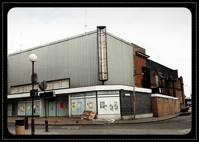
For others who want to read it, it's at: http://micksmuses.com/2010/10/15/walthamstow-memories/ By the way Mick...here's a pic of what was once the cinema at the junction of Colebrook Road and the High Street: |
Tony Quinlan |
|
|
Tony, many thanks for that picture of the old Carlton cinema. Strangely enough, it looks in a better condition boarded up than it did when it was open. The Carlton was always on the lower flea bit end of the cinema scale and it was clear it was nearing it's end when the numbers of the few staff they had there gradually reduced. In the end, the man in the ticket box would also come out of the box to tear ones ticket in half instead of the customary usherette before you entered the cinema. It ended up showing adult films mainly of the titilation variety in an attempt to attract more custom, all to no avail. It then joined the long list of cinemas in Walthamstow and the surrounding districts killed off by television.
|
Historian |
|
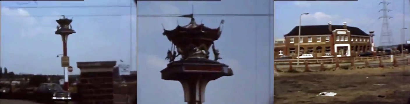
Some screen caps of the Roundabout pub and carousel pub sign at Charlie Brown's circa 1972 not long before it was demolished. The video can been seen here: http://www.youtube.com/watch?v=Phi1wlTMHdQ There's also some interesting footage on the Pathe site from the previous year. Everything in which has gone: http://www.britishpathe.com/video/new-motorway-through-woodford/query/woodford |
ResearchAddict |
|
|
Fantastic footage!
|
Tony Quinlan |
|
|
Many thanks for the links to the Charlie Browns roundabout, they certainly brought back some nostalgic memories. Although like many others I was sad to see the tarmac jungle that replaced it, the film showing the large volumes of traffic was taken 40 years ago so clearly something needed to be done there. I hate to think what that roundabout would be like with todays traffic. The boarded up houses in Mayfield Road reminded me of a similar sight in West London before the A40 was improved. Good houses boarded up and left to decay for some years.
|
Historian |
|
|
Mick, I too have been perusing your excellent website. The photo of the Granada cinema in Hoe Street brought back pleasant memories. I understand its been closed a number of years, pity as the interior was a sort of fantatsic art deco meets moorish design. Just down from the cinema was the Granada shop place where we used to rent our televison back in the days of glorious black and white. After which was the Arcade with a first generation Sainsbury's supermarket. I gather that the Arcade was raised to the ground a few years back in some council inspired property development that never materialised and is just an empty space now. Further down Hoe Street there used to be a garish psychedelic painted boutique which used to scare the daylights out of me as a five year old as I passed by on an RT bus!
|
ResearchAddict |
|
|
Although I now live out in the wilds of central Essex I was actually born in Walthamstow in 1965. After initially living in Leyton we moved out to Redbridge where I spent the next 23 years.
Redbridge, East London and the City (where I’ve worked for almost 30 years) are almost unrecognisable from the areas I grew and visited up during the 1970s, many of the areas I used to know having disappeared under endless tarmac. So much so that a few weeks back I actually got lost between Charlie Brown’s roundabout and Waterworks corner on a rare visit back to the area! Looking at some of the photographs already on the site I realise that the area has changed more in the last 25 years than the 40+ years between when the photos were taken and I first knew them; and not necessarily for the better. However, modern technology means that more and more archive material, such as this site, is now available to us. |
ResearchAddict |
|
|
I know what you mean about not recognising parts of the old East End mate.....I used to live in Colebrook Road E.17, just off the High Street in a lovely little 2 up 2 down Victorian house. It was demolished and replaced by the Selborne Walk Shopping Centre .....Where our old place once stood is now a building society within the mall!..... Walthamstow market was once a wonderful place but now it's just not got the old magic.
|
Tony Quinlan |
|
|
I remember Charlie Browns roundabout with the carousel ontop of a pole outside the pub. The transport cafe also used to double as a motorbike hangout in the evenings. Living in Walthamstow close to the market I certainly knew Colebrook Road with the Carlton cinema on the corner. This eventually became a Tesco supermarket prior to demolition due to the new Selborne Walk Centre. I wrote a series of 'Memory' artiicles about Walthamstow on my website which can be found at http://micksmuses.com/2010/10/15/walthamstow-memories/ Links to the other Walthstow articles can be found in the left column of the screen.
|
Historian |
|
You'll enjoy this old pic of the cafe at Charlie Brown's then
:-) |
Tony Quinlan |
|
|
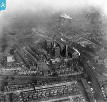
Bryant & May's match factory in Fairfield Road, Bow looking towards Stratford, now known as the Bow Quarter. A heavily industrialised background mixed with terraced residential property is quite visible.
Bryant & May was also the site of one of the first successful industrial strikes in 1888 by female workers over working conditions many who suffered from the disease phossy jaw caused by working with white phosphorus. |
Historian |
|
|
Now converted into apartments, the factory is one of the few surviving features in this photo, apart from the railway line into Liverpool Street. Those that survived the war didn't survive the urban planners. The area to the northeast was swept away by the Blackwall tunnel approach in the 1970s, the A12 extension in the 1990s and now the Olympic stadium complex. Even many of the 1930s industrial buildings constructed after this photo was taken are now long gone.
|
ResearchAddict |
|
|
Eastern Avenue Cranbrook?.....This has to be between Leytonstone and Gants Hill doesn't it?
|
Tony Quinlan |
|
|
The house that I grew up in is one of the light streaks on the left of this photo. Not sure if this is of any assistance but the main feature in shot is ‘Eastern Avenue’ running roughly diagonal across the frame with ‘The Drive’ to Ilford being the road running roughly horizontal. Gants Hill is at one end just above the centre with northern part of Cranbrook Road leading off northwards to what will become Barkingside. At the other end of the photo, the site of what was to become Redbridge Roundabout would be just beyond where the Eastern Avenue runs out of frame on the left.
|
ResearchAddict |
|
|
This picture was taken from near the present day Redbridge Station looking east. The road in the foreground running from left to right is The Drive with the large square being the Port of London Authority recreation ground. The road on the left of the picture is Redbridge Lane East.
|
Historian |
|
|
Although born in Dulwich in 1946, I lived most my life from 5 years old in East London. Firstly Leyton and then Walthamstow. I was a telegram boy on a bicycle at Poplar and then on a motorbike at Forest Gate. I eventually became a firefighter based at Plaistow and knew East London like the back of my hand.
|
Historian |
|
|
Hello Historian.....were you based opposite the Princess Alice when you were on the motorbikes?
|
Tony Quinlan |
|
|
Valentines Park 84 years ago....Spent many happy summers here as a kid...especially in the freezing cold swimming pool.
The cafe is clearly visible in this pic. It was still there last time I visited 3 years ago. |
Tony Quinlan |
|
|
I was born opposite Wanstead Flats in 1949 and lived in Manor Park from then until 1967 before moving to Essex for 4 years...then returned to London and had spells in Streatham, West Norwood, East Ham, Walthamstow and Dagenham until 2004.......now living by the sea in Essex.
I yearn for the old days badly...like most here I expect. |
Tony Quinlan |
|
|
In case anyone is wondering, the profile pic of this group is an aerial view of the Royal Docks looking east, London, September 1934
|
Tony Quinlan |
|
|
I lived in Whitechapel, Mile End and Bow from 1950 - 1997, when I moved to Suffolk. I went to the two Sunday markets most weekends from the end of the 50s to the mid 60s, when something else came up - can't remember what...
|

John Digby |
|
|
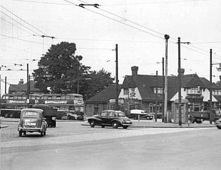
I can see the Town Hall and the Denmark Arms diagonally opposite but I think the old Co-Op wasn't built until 3 years after this pic was taken.
|
Tony Quinlan |
|
|
I only created this group once but it's duplicated itself!
I know the site's having teething problems......I hope it gets sorted. This is the right group to join....the one with comments. |
Tony Quinlan |