
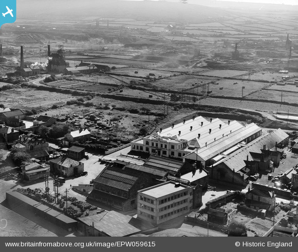
EPW059615 ENGLAND (1938). The Climax Rock Drill and Engineering Works and environs, Carn Brea, 1938
© Copyright OpenStreetMap contributors and licensed by the OpenStreetMap Foundation. 2026. Cartography is licensed as CC BY-SA.
Nearby Images (38)
EPW059615

EAW033748

EAW033749

EPW059612

EAW033747

EPW059618

EAW033750

EAW033746

EAW033742

EAW033744

EAW033751

EPW059611

EPW059616

EPW059609

EAW033743

EAW033752

EAW033745

EPW059610

EPW059613

EPW059614

EPW009925

EPW009920

EPW009918

EPW009919

EPW009921

EPW009924

EPW009923

EPW009922

EAW027869

EAW027870

EAW027878

EAW027879

EAW027880

EAW027877

EAW027873

EAW027871

EAW027875

EAW027876

Details
| Title | [EPW059615] The Climax Rock Drill and Engineering Works and environs, Carn Brea, 1938 |
| Reference | EPW059615 |
| Date | September-1938 |
| Link | |
| Place name | CARN BREA |
| Parish | CARN BREA |
| District | |
| Country | ENGLAND |
| Easting / Northing | 166517, 41267 |
| Longitude / Latitude | -5.2737943939205, 50.224618076513 |
| National Grid Reference | SW665413 |
Pins
Be the first to add a comment to this image!
User Comment Contributions
At the outbreak of WWII my mother Nancy Bennetts did service at The Climax Rock Drill and Engineering Works Ltd., Camborne, Cornwall. Climax was now a weapons manufacturer and Nancy was classified as an inspector. Her job was to work in the Bren Gun machine shop checking machined parts coming of the lathes with Go and No Go gauges and inside and outside micrometers before the guns were assembled. |

Jane B |
Sunday 1st of September 2013 06:50:32 PM |