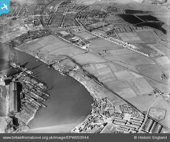
EPW053944 ENGLAND (1937). Hebburn New Town, Pelaw Main and environs, Bill Quay, 1937

© Copyright OpenStreetMap contributors and licensed by the OpenStreetMap Foundation. 2024. Cartography is licensed as CC BY-SA.

Nearby Images (2)

EPW053944
  0° 0m
EPW053692
  343° 150m

Details

Title [EPW053944] Hebburn New Town, Pelaw Main and environs, Bill Quay, 1937
Reference EPW053944
Date June-1937
Link
Place name BILL QUAY
Parish
District
Country ENGLAND
Easting / Northing 430067, 563395
Longitude / Latitude -1.530342861644, 54.964199167325
National Grid Reference NZ301634

Pins

Marian Drive etc

Jan Hood
Saturday 18th of August 2018 01:07:09 PM
In the early 1950s this land was built on and became Windermere Cres Estate, with Grasmere Rd, Thirlmere Court and Coniston Ave.

N Dunn
Saturday 17th of March 2018 03:42:56 PM
In the 1950s quite a bit of this land became allotments.

N Dunn
Saturday 17th of March 2018 03:40:39 PM
St Aloysius RC Church with school attached

N Dunn
Saturday 17th of March 2018 03:38:49 PM
Robert Frazer the steel stockholders premises

N Dunn
Saturday 17th of March 2018 03:37:46 PM
Wailes Dove Bitumastic Factory

N Dunn
Saturday 17th of March 2018 03:36:26 PM
This is the Pyrotenax Company which was between Hedgeley Rd and the Newcastle to South Shields railway lines

N Dunn
Saturday 17th of March 2018 03:35:15 PM

N Dunn
Saturday 17th of March 2018 03:32:22 PM
St Bede's Well was just before the slag heap. Photos on my website www.oldtyneside.co.uk

N Dunn
Saturday 17th of March 2018 03:31:06 PM
This 1937 aerial view must be wrong because this field became Clegwell School's sportsfield and the school is not built yet. The school opened in the late 1930s. They haven't even had foundations installed on this photo. Also across Victoria Rd East on the land opposite there should have been St Aloysius's new school foundations and they are not there either. When WW2 started in 1939 the building of the Aloysius school was abandoned and those foundations and 3ft high walls were there through the 1950s.

N Dunn
Saturday 18th of March 2017 11:08:35 AM
The Pumphouse on the east bank of the 'first lake'. The photo is from my www.oldtyneside.co.uk website

N Dunn
Sunday 3rd of August 2014 10:42:30 AM
Burn Heads Farm. The photo is from my www.oldtyneside.co.uk website.

N Dunn
Sunday 3rd of August 2014 10:36:36 AM
Hartleyburn Ave before houses were built to make a large Housing Estate

N Dunn
Sunday 9th of February 2014 05:14:55 PM
Whickham Rd. The photo is taken looking across Station Rd into Whickham Rd & is from my www.oldtyneside.co.uk website. The wall on the left is the Newtown School wall & the building further on is the 'Free Mason's' Masonic Hall

N Dunn
Sunday 9th of February 2014 05:10:53 PM

N Dunn
Sunday 9th of February 2014 05:06:07 PM
Hall Rd which is a short road & leads from the Victoria Rd traffic lights up to Hebburn's Ellison Hall. The photo is what I took in 2002 & is now on my www.oldtyneside.co.uk website

N Dunn
Sunday 9th of February 2014 05:05:24 PM
Wellington St. I was born at number 47 in June 1944. The photo taken from Hall Rd is from my www.oldtyneside.co.uk website

N Dunn
Sunday 9th of February 2014 05:01:37 PM
In later years Hebburn Technical College was built on this land which is on the corner of Mill Lane & Victoria Rd West.

N Dunn
Sunday 9th of February 2014 04:57:40 PM
Bluehouse Farm in Hebburn and close to the border with Bill Quay.

N Dunn
Sunday 9th of February 2014 04:55:06 PM
Davidson's Farm at Bill Quay opposite Bill Quay School

N Dunn
Sunday 9th of February 2014 04:54:10 PM
Tennant St named after the Tennant family who started a Chemical Works off in Hebburn in the 1860s. The photo is from my www.oldtyneside.co.uk website

N Dunn
Sunday 9th of February 2014 04:52:36 PM
Leslies Sports field just off Victoria Rd East. My pic shows HMS Kelly crew playing bowls two years later in 1939. HMS Kelly was commanded by Lord Louis Mountbatten. More pics can be seen on my www.oldtyneside.co.uk website

N Dunn
Sunday 9th of February 2014 04:49:32 PM
Glen St. The modern day photo is one I took myself & from my www.oldtyneside.co.uk website

N Dunn
Sunday 9th of February 2014 04:44:26 PM
St Cuthbert's Vicarage. It was deliberately built well away from the church because the church was right in among all the housing & the industry. Air pollution in Hebburn was bad due to every house having a coal fire & all of the Industry adding to the pollution problem. So for the health of the Vicar the Vicarage was built out in the country away from the smoke & muck. Photo from my website.

N Dunn
Saturday 11th of January 2014 10:47:52 AM
This was a Reservoir belonging the Tharsis Sulpher & Copper Company. It was deep & brick lined & the sides were on a 45 degree angle. When Tharsis pulled out of Hebburn the reservoir (known as the Copperworks Pond) was left unfenced & local kids played there & caught sticklebacks. I remember being there & you could look down & see the sloping sides disappear into the darkness. I think it was supposed to be about 30ft deep. In the early 1950s a lad called Colqhoun from Hebburn Quay area fell in & drowned. Because of the sloping sides, anyone falling into it was in deep water immediately. In previous years ( early 1900s) when the Company were still operating two children from one family drowned there as it was very close to the houses in Glen St.

N Dunn
Saturday 7th of December 2013 02:39:22 PM
Hebburn Hall and sometimes known as Ellison Hall since the Ellison's bought it in 1648.

N Dunn
Monday 9th of September 2013 07:19:20 PM

N Dunn
Monday 9th of September 2013 03:41:49 PM
This is the main road to South Shields & it's Victoria Rd West. When it gets past Station Road in Hebburn it becomes Victoria Rd East. When the same road reaches Jarrow it then becomes Albert Rd.

N Dunn
Monday 9th of September 2013 03:39:24 PM
On my 1916 map this is 'The Elders'. This house could possibly be where the Morris family lived as they had a small shipyard about here. I've attached a sketch from my www.oldtyneside.co.uk website

N Dunn
Monday 9th of September 2013 02:52:32 PM
St John's Church in Hebburn had a small Mission Hall just over the line from Primrose Cottage. It was called 'St John's Mission Room. All my information has been checked via my 1916 Map.

N Dunn
Monday 9th of September 2013 02:36:41 PM
This was the 'Deans Primrose Staiths' so coal from another Pit would have been shipped from this Staith.

N Dunn
Monday 9th of September 2013 02:34:16 PM
Primrose Cottage

N Dunn
Monday 9th of September 2013 02:31:50 PM
Wraithe Ville where employees of the coal company lived. After 1947 it would have been the NCB running the Staiths.

N Dunn
Monday 9th of September 2013 02:31:09 PM
The Staith House Public House at Pelaw Main. The photo is from my www.gatesheadeast.co.uk website. A few yards along from the Hotel was a Pub called 'The Tennant's Arms'. So plenty places to drink in those days.

N Dunn
Monday 9th of September 2013 02:29:09 PM
I think, actually, the pub was further back (East). I think that the frontage you can see is my Dad's old house that he was born in in 1908. It had no electricity, gas or even running water. Later after the 'Lynches' moved to Croxdale Gardens Bill Quay, via Wraith Villas, he and my Mother lived in Mill lane. From there he would often take me down to Pelaw Main to play with my friend who's parents ran the Tennants Arms. I remember being given a boiled egg. This would have been middle to late 1950's.

Harry Lynch
Thursday 29th of December 2016 06:14:59 PM
Harrison's Ship Yard at Bill Quay. It was originally 'Boutland's' where wooded ships were built. The photo is from my website www.gatesheadeast.co.uk

N Dunn
Monday 9th of September 2013 02:24:56 PM
Pelaw Main Staiths at Bill Quay. Pelaw Main was a Colliery near Chester Le Street area & it's coal was brought to these Staiths in rail trucks. From Springwell near Wrekenton the trucks were lowered by gravity all the way to the Staiths. They were kept from gaining speed downhill by a rope haulage system which hauled them back to Springwell once emptied. The attached photo is from my www.gatesheadeast.co.uk website

N Dunn
Monday 9th of September 2013 02:21:18 PM
The Bauxite Factory which when I was a lad in the 1950s was long gone. When they left they left a lot of mess behind. As kids we played around that area as there was a Reservoir for us to fish in & play on an old Raft. Close to the reservoir were mounds of reddish soil like material which was something to do with bauxite waste. It was all contaminated land & had to be disposed of. Todat Marina View stands on that land.

N Dunn
Sunday 25th of August 2013 11:35:06 AM
Whites Marine Factory

N Dunn
Sunday 25th of August 2013 11:30:54 AM

N Dunn
Sunday 25th of August 2013 11:29:43 AM
The Bushing Company

N Dunn
Sunday 25th of August 2013 11:29:11 AM
South Drive. My photo shows Reyrolles Sportsfield Fence on the right. Further down South Drive on the left is the Bushing Company building.

N Dunn
Sunday 25th of August 2013 11:28:35 AM
This lake was called 'Sandy Bottom'. In the late 1950s a number of children ( 3 I think) fell through the ice on this lake & were drowned. Because of this tragedy the Council decided to drain the Lakes. Once drained, houses & schools were built on the land.

N Dunn
Sunday 25th of August 2013 11:25:42 AM
This is the 2nd Lake & the pin is roughly where the old Boathouse was located at the edge of the Lake. This photo from my website www.oldtyneside.co.uk shows the remains of the boathouse with the Park in the background

N Dunn
Sunday 25th of August 2013 11:21:36 AM
This is the First Lake & as far as Hebburn Park extended. In the 50s I remember the wooden fence around the perimeter of the Park & there was a gate close to the corner of the park fence close to the corner of the lake.

N Dunn
Sunday 25th of August 2013 11:17:11 AM
Hebburn Park which stretched from St John's Ave to as far as the east end of the First Lake & old Quarry. The Park was one the private garden of the Carr Ellison family as were the four lakes. The second lake had a Boathouse where the Carr Ellison's kept their boats. They sailed & fished on the lakes. The Lakes were only constructed in the mid to late 1800s & were drained at the end of the 1950s maybe early 1960s.Here is a photo from my website showing the Park gardeners.

N Dunn
Sunday 25th of August 2013 11:12:04 AM
The covered over Reservoir on the corner of Victoria Rd West & Mill Lane in Hebburn.

N Dunn
Sunday 25th of August 2013 11:05:06 AM
I lived in Mill Lane as a lad. This reservoir had one entrance at the top which we bent the bars and got into. There was an 'exit' at 'The High Road' (Victoria Road West) end. The 'Duffa!' was to get from one end to another...it was dark, dank, rat infested and EXTREMELY dangerous as it had hidden lower tanks....still we often did it. I wouldn't dream of doing it now.

Harry Lynch
Thursday 29th of December 2016 06:08:14 PM
Reyrolles Sports Field with Victoria Rd West just over the fence. My photo from my website www.oldtyneside.co.uk shows the field in the 1980s

N Dunn
Sunday 25th of August 2013 11:03:18 AM
Hebburn Railway Station

N Dunn
Tuesday 6th of August 2013 07:59:38 PM

N Dunn
Tuesday 6th of August 2013 07:58:38 PM

N Dunn
Tuesday 6th of August 2013 07:58:00 PM
The old Quarry which was at the east end of the Park . Later Leslies Sports field was made slightly north of this quarry

N Dunn
Tuesday 6th of August 2013 07:57:28 PM
Tharsis Copper Works

N Dunn
Tuesday 6th of August 2013 07:55:31 PM
The 4 Hebburn lakes, which were made for the Ellison Family as garden ponds. The Park was also their garden.

N Dunn
Tuesday 6th of August 2013 07:54:33 PM
Walker Naval Yard

N Dunn
Tuesday 6th of August 2013 07:51:29 PM