
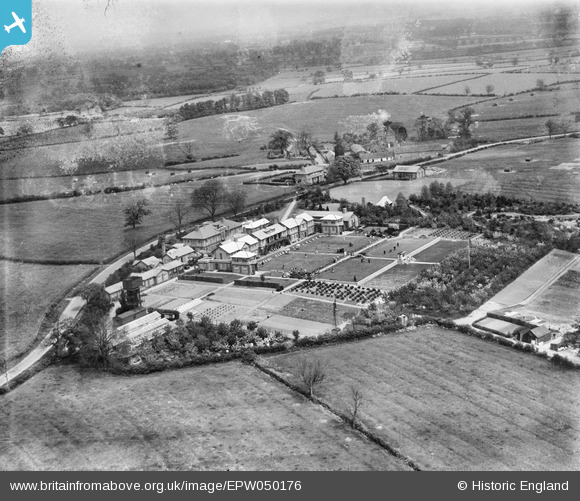
EPW050176 ENGLAND (1936). The NATSOPA Memorial Home and surrounding countryside, Wellsborough, 1936
© Copyright OpenStreetMap contributors and licensed by the OpenStreetMap Foundation. 2026. Cartography is licensed as CC BY-SA.
Nearby Images (25)
EPW050176

EPW050166

EPW050178

EPW050180

EPW050173

EPW050168

EPW050169

EPW050175

EAW025252
 Memorial Home, Wellsborough, from the south-east, 1949")
EPW050167

EAW025253
 Memorial Home, Wellsborough, from the north-west, 1949")
EPW050174

EPW050179

EAW025251
 Memorial Home, Wellsborough, from the north-west, 1949")
EPW050177

EPW050165

EAW025255
 Memorial Home and environs, Wellsborough, from the south-west, 1949")
EAW025247
 Memorial Home, Wellsborough, from the south-east, 1949")
EAW025257
 Memorial Home, Wellsborough, from the south-west, 1949")
EAW025250
 Memorial Home, Wellsborough, from the south-east, 1949")
EAW025256
 Memorial Home, Wellsborough, from the south-west, 1949")
EAW025254
 Memorial Home and environs, Wellsborough, from the south-west, 1949")
EPW050172

EAW025248
 Memorial Home, Wellsborough, 1949")
EPW050171

Details
| Title | [EPW050176] The NATSOPA Memorial Home and surrounding countryside, Wellsborough, 1936 |
| Reference | EPW050176 |
| Date | May-1936 |
| Link | |
| Place name | WELLSBOROUGH |
| Parish | SHEEPY |
| District | |
| Country | ENGLAND |
| Easting / Northing | 436062, 302313 |
| Longitude / Latitude | -1.4672941769638, 52.617035375926 |
| National Grid Reference | SK361023 |
Pins

totoro |
Tuesday 15th of March 2016 09:05:54 PM | |
|
totoro |
Tuesday 15th of March 2016 08:53:59 PM | |
|
totoro |
Tuesday 15th of March 2016 08:50:35 PM | |
|
totoro |
Tuesday 15th of March 2016 08:48:31 PM |