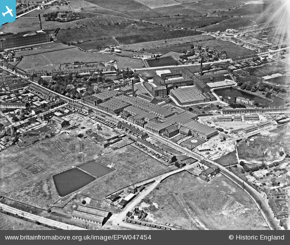
EPW047454 ENGLAND (1935). Newton Mill, Ashton Road and environs, Hyde, 1935
© Copyright OpenStreetMap contributors and licensed by the OpenStreetMap Foundation. 2025. Cartography is licensed as CC BY-SA.
Nearby Images (20)
Details
| Title | [EPW047454] Newton Mill, Ashton Road and environs, Hyde, 1935 |
| Reference | EPW047454 |
| Date | May-1935 |
| Link | |
| Place name | HYDE |
| Parish | |
| District | |
| Country | ENGLAND |
| Easting / Northing | 395289, 396000 |
| Longitude / Latitude | -2.0709618489781, 53.460472926578 |
| National Grid Reference | SJ953960 |
Pins
Be the first to add a comment to this image!


![[EPW047454] Newton Mill, Ashton Road and environs, Hyde, 1935](http://britainfromabove.org.uk/sites/all/libraries/aerofilms-images/public/100x100/EPW/047/EPW047454.jpg)
![[EPW047455] Newton Mill, Ashton Road and environs, Hyde, 1935](http://britainfromabove.org.uk/sites/all/libraries/aerofilms-images/public/100x100/EPW/047/EPW047455.jpg)
![[EAW008510] The Newton Mill Stationery Manufactory, Hyde, 1947](http://britainfromabove.org.uk/sites/all/libraries/aerofilms-images/public/100x100/EAW/008/EAW008510.jpg)
![[EPW047458] Newton Mill, Ashton Road and environs, Hyde, 1935](http://britainfromabove.org.uk/sites/all/libraries/aerofilms-images/public/100x100/EPW/047/EPW047458.jpg)
![[EAW008504] The Newton Mill Stationery Manufactory, Hyde, 1947](http://britainfromabove.org.uk/sites/all/libraries/aerofilms-images/public/100x100/EAW/008/EAW008504.jpg)
![[EAW008507] The Newton Mill Stationery Manufactory, Hyde, 1947](http://britainfromabove.org.uk/sites/all/libraries/aerofilms-images/public/100x100/EAW/008/EAW008507.jpg)
![[EAW008508] The Newton Mill Stationery Manufactory, Hyde, 1947](http://britainfromabove.org.uk/sites/all/libraries/aerofilms-images/public/100x100/EAW/008/EAW008508.jpg)
![[EAW008511] The Newton Mill Stationery Manufactory, Hyde, 1947](http://britainfromabove.org.uk/sites/all/libraries/aerofilms-images/public/100x100/EAW/008/EAW008511.jpg)
![[EAW008505] The Newton Mill Stationery Manufactory, Hyde, 1947](http://britainfromabove.org.uk/sites/all/libraries/aerofilms-images/public/100x100/EAW/008/EAW008505.jpg)
![[EPW047456] Newton Mill, Ashton Road and environs, Hyde, 1935](http://britainfromabove.org.uk/sites/all/libraries/aerofilms-images/public/100x100/EPW/047/EPW047456.jpg)
![[EPW047452] Newton Mill, Ashton Road and environs, Hyde, 1935](http://britainfromabove.org.uk/sites/all/libraries/aerofilms-images/public/100x100/EPW/047/EPW047452.jpg)
![[EAW008506] The Newton Mill Stationery Manufactory, Hyde, 1947](http://britainfromabove.org.uk/sites/all/libraries/aerofilms-images/public/100x100/EAW/008/EAW008506.jpg)
![[EPW047457] Newton Mill, Ashton Road and environs, Hyde, 1935](http://britainfromabove.org.uk/sites/all/libraries/aerofilms-images/public/100x100/EPW/047/EPW047457.jpg)
![[EAW008515] The Newton Mill Stationery Manufactory and the Newton Moor Cotton Mills, Hyde, 1947](http://britainfromabove.org.uk/sites/all/libraries/aerofilms-images/public/100x100/EAW/008/EAW008515.jpg)
![[EAW008509] The Newton Mill Stationery Manufactory, Hyde, 1947](http://britainfromabove.org.uk/sites/all/libraries/aerofilms-images/public/100x100/EAW/008/EAW008509.jpg)
![[EAW008514] The Newton Mill Stationery Manufactory, Hyde, 1947](http://britainfromabove.org.uk/sites/all/libraries/aerofilms-images/public/100x100/EAW/008/EAW008514.jpg)
![[EPW047453] Newton Mill, Ashton Road and environs, Hyde, 1935](http://britainfromabove.org.uk/sites/all/libraries/aerofilms-images/public/100x100/EPW/047/EPW047453.jpg)
![[EAW008512] The Newton Mill Stationery Manufactory, Hyde, 1947](http://britainfromabove.org.uk/sites/all/libraries/aerofilms-images/public/100x100/EAW/008/EAW008512.jpg)
![[EAW008503] The Newton Mill Stationery Manufactory, Hyde, from the east, 1947](http://britainfromabove.org.uk/sites/all/libraries/aerofilms-images/public/100x100/EAW/008/EAW008503.jpg)
![[EAW008513] The Newton Mill Stationery Manufactory and the Newton Moor Cotton Mills, Hyde, 1947](http://britainfromabove.org.uk/sites/all/libraries/aerofilms-images/public/100x100/EAW/008/EAW008513.jpg)