
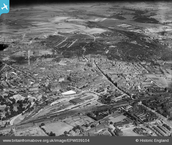
EPW039104 ENGLAND (1932). The city centre, Wakefield, 1932
© Copyright OpenStreetMap contributors and licensed by the OpenStreetMap Foundation. 2026. Cartography is licensed as CC BY-SA.
Nearby Images (18)
EPW039104

EPW039103

EPW016287

EPW016289

EPW039105

EPW016285

EAW015510

EAW015515

EPW039106

EAW025172

EAW015513

EAW015514

EAW015511

EPW061508

EAW015516

EAW015512

EAW025171

EAW025174

Details
| Title | [EPW039104] The city centre, Wakefield, 1932 |
| Reference | EPW039104 |
| Date | July-1932 |
| Link | |
| Place name | WAKEFIELD |
| Parish | |
| District | |
| Country | ENGLAND |
| Easting / Northing | 433245, 420875 |
| Longitude / Latitude | -1.4965917475642, 53.68304630278 |
| National Grid Reference | SE332209 |
Pins
sirdouglas |
Wednesday 9th of April 2014 03:04:30 PM | |
|
sirdouglas |
Friday 4th of April 2014 02:13:33 PM | |
|
sirdouglas |
Friday 4th of April 2014 02:09:50 PM | |
|
sirdouglas |
Friday 4th of April 2014 02:08:41 PM | |
|
sirdouglas |
Friday 4th of April 2014 02:05:23 PM | |
|
sirdouglas |
Friday 4th of April 2014 02:04:10 PM | |
|
sirdouglas |
Friday 4th of April 2014 02:01:36 PM | |
|
sirdouglas |
Friday 4th of April 2014 02:00:09 PM | |
|
sirdouglas |
Friday 4th of April 2014 01:54:59 PM | |
|
sirdouglas |
Friday 4th of April 2014 01:48:39 PM | |
|
sirdouglas |
Friday 4th of April 2014 01:41:48 PM | |
|
sirdouglas |
Friday 4th of April 2014 01:38:51 PM | |
|
sirdouglas |
Friday 4th of April 2014 01:31:34 PM |