
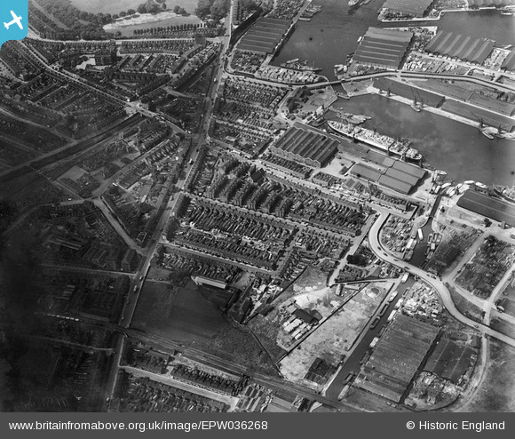
EPW036268 ENGLAND (1931). Sutton Dwellings at Chilton Grove and Lower Road, Rotherhithe, 1931
© Copyright OpenStreetMap contributors and licensed by the OpenStreetMap Foundation. 2026. Cartography is licensed as CC BY-SA.
Nearby Images (19)
EPW036268

EPW036266

EPW035609

EPW035611

EPW035608

EPW035612

EPW036267

EPW036264

EPW035610

EPW036263

EPW035613

EAW033237

EAW033240

EAW033239

EAW033238

EAW033242

EAW033182

EAW033184

EPW044145

Details
| Title | [EPW036268] Sutton Dwellings at Chilton Grove and Lower Road, Rotherhithe, 1931 |
| Reference | EPW036268 |
| Date | August-1931 |
| Link | |
| Place name | ROTHERHITHE |
| Parish | |
| District | |
| Country | ENGLAND |
| Easting / Northing | 536031, 178779 |
| Longitude / Latitude | -0.040367461372329, 51.491086973506 |
| National Grid Reference | TQ360788 |
Pins

mannidaze |
Saturday 7th of January 2017 07:10:21 PM | |
|
John W |
Thursday 5th of January 2017 07:58:28 PM | |
|
John W |
Thursday 5th of January 2017 07:54:05 PM | |
|
John W |
Thursday 5th of January 2017 07:46:42 PM | |
|
brianbeckett |
Sunday 12th of October 2014 10:15:40 AM | |
|
brianbeckett |
Sunday 12th of October 2014 10:15:01 AM | |
|
brianbeckett |
Sunday 12th of October 2014 10:14:22 AM | |
|
brianbeckett |
Sunday 12th of October 2014 10:13:58 AM | |
|
brianbeckett |
Sunday 12th of October 2014 10:13:40 AM | |
|
brianbeckett |
Sunday 12th of October 2014 10:13:05 AM | |
|
brianbeckett |
Sunday 12th of October 2014 10:12:41 AM |