
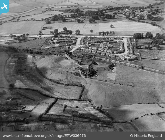
EPW036076 ENGLAND (1931). Killingbeck Colliery, Sutton Approach and environs, Killingbeck, 1931
© Copyright OpenStreetMap contributors and licensed by the OpenStreetMap Foundation. 2026. Cartography is licensed as CC BY-SA.
Nearby Images (10)
EPW036076

EPW036073

EPW036074

EPW036075

EPW036077

EPW036072

EPW036071

EPW036068

EPW036070

EPW036067

Details
| Title | [EPW036076] Killingbeck Colliery, Sutton Approach and environs, Killingbeck, 1931 |
| Reference | EPW036076 |
| Date | 18-July-1931 |
| Link | |
| Place name | KILLINGBECK |
| Parish | |
| District | |
| Country | ENGLAND |
| Easting / Northing | 434629, 434088 |
| Longitude / Latitude | -1.474154992275, 53.801724337961 |
| National Grid Reference | SE346341 |
Pins

PCM |
Tuesday 28th of January 2025 01:20:38 PM | |
|
PCM |
Tuesday 28th of January 2025 01:20:02 PM | |
|
PCM |
Tuesday 28th of January 2025 01:19:24 PM | |
|
PCM |
Tuesday 28th of January 2025 01:18:56 PM | |
|
PCM |
Tuesday 28th of January 2025 01:16:33 PM | |
|
PCM |
Tuesday 28th of January 2025 01:15:06 PM | |
|
PCM |
Tuesday 28th of January 2025 01:13:14 PM | |
|
PCM |
Tuesday 28th of January 2025 01:12:52 PM | |
|
PCM |
Tuesday 28th of January 2025 12:58:23 PM | |
|
PCM |
Tuesday 28th of January 2025 12:57:29 PM | |
|
PCM |
Tuesday 28th of January 2025 12:57:04 PM | |
|
PCM |
Tuesday 28th of January 2025 12:56:20 PM | |
|
PCM |
Tuesday 28th of January 2025 12:56:05 PM | |
|
PCM |
Tuesday 28th of January 2025 12:55:13 PM | |
|
PCM |
Tuesday 28th of January 2025 12:54:46 PM | |
|
PCM |
Tuesday 28th of January 2025 12:54:29 PM |