
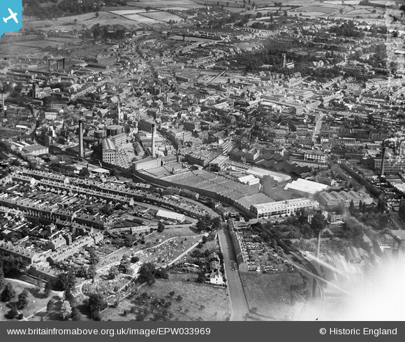
EPW033969 ENGLAND (1930). The town centre, Kidderminster, from the south-west, 1930
© Copyright OpenStreetMap contributors and licensed by the OpenStreetMap Foundation. 2026. Cartography is licensed as CC BY-SA.
Nearby Images (23)
EPW033969

EPW033977

EPW033979

EPW034227

EPW033972

EPW033973

EPW033970

EPW033974

EPW033971

EPW033975

EPW033976

EPW059212

EPW037599

EPW001297

EPW033968

EPW059213

EPW059215

EPW034232

EPW059217

EPW059211

EPW059214

EPW059216

EPW037602

Details
| Title | [EPW033969] The town centre, Kidderminster, from the south-west, 1930 |
| Reference | EPW033969 |
| Date | July-1930 |
| Link | |
| Place name | KIDDERMINSTER |
| Parish | |
| District | |
| Country | ENGLAND |
| Easting / Northing | 382944, 276241 |
| Longitude / Latitude | -2.2506183351334, 52.383554651049 |
| National Grid Reference | SO829762 |
Pins

Bob |
Saturday 23rd of January 2016 01:15:47 PM | |
|
Bob |
Saturday 23rd of January 2016 10:20:03 AM | |
|
The_Engineer |
Wednesday 29th of October 2014 04:10:26 PM | |
No. This is the New Meeting Church. |
Bob |
Saturday 23rd of January 2016 10:18:28 AM |
|
The_Engineer |
Wednesday 29th of October 2014 04:09:33 PM | |
|
The_Engineer |
Wednesday 29th of October 2014 04:09:01 PM | |
|
The_Engineer |
Wednesday 29th of October 2014 04:07:28 PM | |
|
The_Engineer |
Wednesday 29th of October 2014 04:07:07 PM | |
|
alanpreece |
Sunday 23rd of February 2014 04:57:35 PM | |
|
alanpreece |
Sunday 23rd of February 2014 04:56:04 PM | |
|
alanpreece |
Sunday 23rd of February 2014 04:54:47 PM |