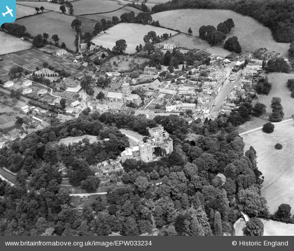
EPW033234 ENGLAND (1930). Dunster Castle and environs, Dunster, 1930
© Copyright OpenStreetMap contributors and licensed by the OpenStreetMap Foundation. 2025. Cartography is licensed as CC BY-SA.
Nearby Images (17)
Details
| Title | [EPW033234] Dunster Castle and environs, Dunster, 1930 |
| Reference | EPW033234 |
| Date | July-1930 |
| Link | |
| Place name | DUNSTER |
| Parish | DUNSTER |
| District | |
| Country | ENGLAND |
| Easting / Northing | 299110, 143599 |
| Longitude / Latitude | -3.4436335108244, 51.182187951914 |
| National Grid Reference | SS991436 |
Pins
 Class31 |
Monday 22nd of September 2014 10:35:05 AM |


![[EPW033234] Dunster Castle and environs, Dunster, 1930](http://britainfromabove.org.uk/sites/all/libraries/aerofilms-images/public/100x100/EPW/033/EPW033234.jpg)
![[EAW015009] Dunster Castle, Dunster, 1948. This image has been produced from a damaged negative.](http://britainfromabove.org.uk/sites/all/libraries/aerofilms-images/public/100x100/EAW/015/EAW015009.jpg)
![[EPW033231] Dunster Castle and environs, Dunster, 1930](http://britainfromabove.org.uk/sites/all/libraries/aerofilms-images/public/100x100/EPW/033/EPW033231.jpg)
![[EPW033723] Dunster Castle and the village, Dunster, 1930](http://britainfromabove.org.uk/sites/all/libraries/aerofilms-images/public/100x100/EPW/033/EPW033723.jpg)
![[EAW015007] Dunster Castle, Dunster, 1948. This image has been produced from a damaged negative.](http://britainfromabove.org.uk/sites/all/libraries/aerofilms-images/public/100x100/EAW/015/EAW015007.jpg)
![[EAW005862] Dunster Castle and the village, Dunster, 1947. This image has been produced from a print.](http://britainfromabove.org.uk/sites/all/libraries/aerofilms-images/public/100x100/EAW/005/EAW005862.jpg)
![[EPW033721] St George's Church and environs, Dunster, 1930](http://britainfromabove.org.uk/sites/all/libraries/aerofilms-images/public/100x100/EPW/033/EPW033721.jpg)
![[EAW005864] Dunster Castle, Dunster, 1947. This image has been produced from a print.](http://britainfromabove.org.uk/sites/all/libraries/aerofilms-images/public/100x100/EAW/005/EAW005864.jpg)
![[EPW033722] Dunster Castle and the village, Dunster, 1930](http://britainfromabove.org.uk/sites/all/libraries/aerofilms-images/public/100x100/EPW/033/EPW033722.jpg)
![[EAW015010] Dunster Castle, Dunster, 1948. This image has been produced from a print.](http://britainfromabove.org.uk/sites/all/libraries/aerofilms-images/public/100x100/EAW/015/EAW015010.jpg)
![[EAW005860] Dunster Castle, Dunster, 1947](http://britainfromabove.org.uk/sites/all/libraries/aerofilms-images/public/100x100/EAW/005/EAW005860.jpg)
![[EAW015008] Dunster Castle, Dunster, 1948. This image has been produced from a damaged negative.](http://britainfromabove.org.uk/sites/all/libraries/aerofilms-images/public/100x100/EAW/015/EAW015008.jpg)
![[EAW005863] Dunster Castle, Dunster, 1947. This image has been produced from a print.](http://britainfromabove.org.uk/sites/all/libraries/aerofilms-images/public/100x100/EAW/005/EAW005863.jpg)
![[EAW015006] Dunster Castle and St George's Church, Dunster, 1948. This image has been produced from a damaged negative.](http://britainfromabove.org.uk/sites/all/libraries/aerofilms-images/public/100x100/EAW/015/EAW015006.jpg)
![[EPW033233] Dunster Castle and environs, Dunster, 1930](http://britainfromabove.org.uk/sites/all/libraries/aerofilms-images/public/100x100/EPW/033/EPW033233.jpg)
![[EAW005861] Dunster Castle, Dunster, 1947. This image has been produced from a print.](http://britainfromabove.org.uk/sites/all/libraries/aerofilms-images/public/100x100/EAW/005/EAW005861.jpg)
![[EAW015015] The village, Dunster, from the north-east, 1948. This image has been produced from a print.](http://britainfromabove.org.uk/sites/all/libraries/aerofilms-images/public/100x100/EAW/015/EAW015015.jpg)