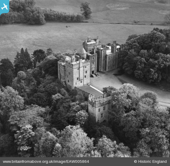
EAW005864 ENGLAND (1947). Dunster Castle, Dunster, 1947. This image has been produced from a print.
© Copyright OpenStreetMap contributors and licensed by the OpenStreetMap Foundation. 2025. Cartography is licensed as CC BY-SA.
Nearby Images (16)
Details
| Title | [EAW005864] Dunster Castle, Dunster, 1947. This image has been produced from a print. |
| Reference | EAW005864 |
| Date | 18-May-1947 |
| Link | |
| Place name | DUNSTER |
| Parish | DUNSTER |
| District | |
| Country | ENGLAND |
| Easting / Northing | 299187, 143506 |
| Longitude / Latitude | -3.4425059931248, 51.181365455923 |
| National Grid Reference | SS992435 |
Pins
Be the first to add a comment to this image!
User Comment Contributions
Dunster Castle, 21/09/2014 |
 Class31 |
Monday 29th of September 2014 10:46:25 PM |


![[EAW005864] Dunster Castle, Dunster, 1947. This image has been produced from a print.](http://britainfromabove.org.uk/sites/all/libraries/aerofilms-images/public/100x100/EAW/005/EAW005864.jpg)
![[EAW015010] Dunster Castle, Dunster, 1948. This image has been produced from a print.](http://britainfromabove.org.uk/sites/all/libraries/aerofilms-images/public/100x100/EAW/015/EAW015010.jpg)
![[EAW015008] Dunster Castle, Dunster, 1948. This image has been produced from a damaged negative.](http://britainfromabove.org.uk/sites/all/libraries/aerofilms-images/public/100x100/EAW/015/EAW015008.jpg)
![[EAW005863] Dunster Castle, Dunster, 1947. This image has been produced from a print.](http://britainfromabove.org.uk/sites/all/libraries/aerofilms-images/public/100x100/EAW/005/EAW005863.jpg)
![[EAW005862] Dunster Castle and the village, Dunster, 1947. This image has been produced from a print.](http://britainfromabove.org.uk/sites/all/libraries/aerofilms-images/public/100x100/EAW/005/EAW005862.jpg)
![[EPW033233] Dunster Castle and environs, Dunster, 1930](http://britainfromabove.org.uk/sites/all/libraries/aerofilms-images/public/100x100/EPW/033/EPW033233.jpg)
![[EAW015006] Dunster Castle and St George's Church, Dunster, 1948. This image has been produced from a damaged negative.](http://britainfromabove.org.uk/sites/all/libraries/aerofilms-images/public/100x100/EAW/015/EAW015006.jpg)
![[EAW005861] Dunster Castle, Dunster, 1947. This image has been produced from a print.](http://britainfromabove.org.uk/sites/all/libraries/aerofilms-images/public/100x100/EAW/005/EAW005861.jpg)
![[EAW005860] Dunster Castle, Dunster, 1947](http://britainfromabove.org.uk/sites/all/libraries/aerofilms-images/public/100x100/EAW/005/EAW005860.jpg)
![[EAW015007] Dunster Castle, Dunster, 1948. This image has been produced from a damaged negative.](http://britainfromabove.org.uk/sites/all/libraries/aerofilms-images/public/100x100/EAW/015/EAW015007.jpg)
![[EPW033231] Dunster Castle and environs, Dunster, 1930](http://britainfromabove.org.uk/sites/all/libraries/aerofilms-images/public/100x100/EPW/033/EPW033231.jpg)
![[EAW015009] Dunster Castle, Dunster, 1948. This image has been produced from a damaged negative.](http://britainfromabove.org.uk/sites/all/libraries/aerofilms-images/public/100x100/EAW/015/EAW015009.jpg)
![[EPW033234] Dunster Castle and environs, Dunster, 1930](http://britainfromabove.org.uk/sites/all/libraries/aerofilms-images/public/100x100/EPW/033/EPW033234.jpg)
![[EPW033723] Dunster Castle and the village, Dunster, 1930](http://britainfromabove.org.uk/sites/all/libraries/aerofilms-images/public/100x100/EPW/033/EPW033723.jpg)
![[EPW033721] St George's Church and environs, Dunster, 1930](http://britainfromabove.org.uk/sites/all/libraries/aerofilms-images/public/100x100/EPW/033/EPW033721.jpg)
![[EPW033722] Dunster Castle and the village, Dunster, 1930](http://britainfromabove.org.uk/sites/all/libraries/aerofilms-images/public/100x100/EPW/033/EPW033722.jpg)