
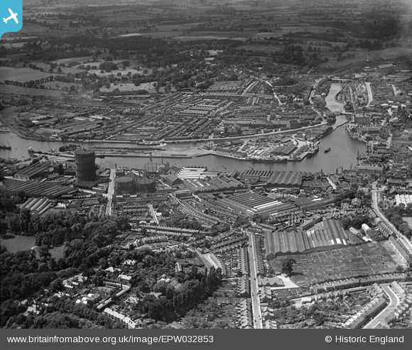
EPW032853 ENGLAND (1930). The docks, Ipswich, 1930
© Copyright OpenStreetMap contributors and licensed by the OpenStreetMap Foundation. 2026. Cartography is licensed as CC BY-SA.
Nearby Images (17)
EPW032853

EPW032859

EPW032837

EPW032836

EPW032877

EPW032849

EAW033332

EPW041400

EPW059177

EPW058769
 Ltd timber works, Three Cranes Wharf and environs, Ipswich, 1938")
EPW032856

EPW058764
 Ltd timber works, Wet Dock and environs, Ipswich, 1938")
EPW032858

EPW058768
 Ltd timber works, Wet Dock and environs, Ipswich, 1938")
EPW058765
 Ltd timber works, Wet Dock and environs, Ipswich, 1938")
EPW058766
 Ltd timber works, Three Cranes Wharf and environs, Ipswich, 1938")
EPW032845

Details
| Title | [EPW032853] The docks, Ipswich, 1930 |
| Reference | EPW032853 |
| Date | June-1930 |
| Link | |
| Place name | IPSWICH |
| Parish | |
| District | |
| Country | ENGLAND |
| Easting / Northing | 616989, 243715 |
| Longitude / Latitude | 1.1649172474092, 52.048855715124 |
| National Grid Reference | TM170437 |
Pins

Where's Canning Town? |
Saturday 15th of March 2014 08:27:42 PM |
User Comment Contributions
A further history of the whole area can be read: http://www.ipswichtransportmuseum.co.uk/Ransomes.htm |
Where's Canning Town? |
Saturday 15th of March 2014 08:41:29 PM |