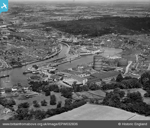
EPW032836 ENGLAND (1930). The docks, Ipswich, 1930
© Copyright OpenStreetMap contributors and licensed by the OpenStreetMap Foundation. 2026. Cartography is licensed as CC BY-SA.
Nearby Images (21)
Details
| Title | [EPW032836] The docks, Ipswich, 1930 |
| Reference | EPW032836 |
| Date | June-1930 |
| Link | |
| Place name | IPSWICH |
| Parish | |
| District | |
| Country | ENGLAND |
| Easting / Northing | 616893, 243660 |
| Longitude / Latitude | 1.1634844335979, 52.048399499151 |
| National Grid Reference | TM169437 |


![[EPW032836] The docks, Ipswich, 1930](http://britainfromabove.org.uk/sites/all/libraries/aerofilms-images/public/100x100/EPW/032/EPW032836.jpg)
![[EPW032859] The docks and environs, Ipswich, 1930](http://britainfromabove.org.uk/sites/all/libraries/aerofilms-images/public/100x100/EPW/032/EPW032859.jpg)
![[EPW032877] The docks and town, Ipswich, 1930](http://britainfromabove.org.uk/sites/all/libraries/aerofilms-images/public/100x100/EPW/032/EPW032877.jpg)
![[EPW032837] The docks, Ipswich, 1930](http://britainfromabove.org.uk/sites/all/libraries/aerofilms-images/public/100x100/EPW/032/EPW032837.jpg)
![[EPW032853] The docks, Ipswich, 1930](http://britainfromabove.org.uk/sites/all/libraries/aerofilms-images/public/100x100/EPW/032/EPW032853.jpg)
![[EAW033332] Ipswich Dock, New Cut and the town, Ipswich, 1950](http://britainfromabove.org.uk/sites/all/libraries/aerofilms-images/public/100x100/EAW/033/EAW033332.jpg)
![[EPW032849] The Eagle Mills and docks, Ipswich, 1930](http://britainfromabove.org.uk/sites/all/libraries/aerofilms-images/public/100x100/EPW/032/EPW032849.jpg)
![[EPW032858] The docks and environs, Ipswich, 1930](http://britainfromabove.org.uk/sites/all/libraries/aerofilms-images/public/100x100/EPW/032/EPW032858.jpg)
![[EAW033331] Ipswich Dock, New Cut and Stoke, Ipswich, 1950](http://britainfromabove.org.uk/sites/all/libraries/aerofilms-images/public/100x100/EAW/033/EAW033331.jpg)
![[EPW041400] The Gas Works on Patteson Road and environs, Ipswich, 1933](http://britainfromabove.org.uk/sites/all/libraries/aerofilms-images/public/100x100/EPW/041/EPW041400.jpg)
![[EPW058769] The William Brown & Co (Ipswich) Ltd timber works, Three Cranes Wharf and environs, Ipswich, 1938](http://britainfromabove.org.uk/sites/all/libraries/aerofilms-images/public/100x100/EPW/058/EPW058769.jpg)
![[EPW032856] Tovell's Wharf and environs, Ipswich, 1930](http://britainfromabove.org.uk/sites/all/libraries/aerofilms-images/public/100x100/EPW/032/EPW032856.jpg)
![[EPW058764] The William Brown & Co (Ipswich) Ltd timber works, Wet Dock and environs, Ipswich, 1938](http://britainfromabove.org.uk/sites/all/libraries/aerofilms-images/public/100x100/EPW/058/EPW058764.jpg)
![[EPW058768] The William Brown & Co (Ipswich) Ltd timber works, Wet Dock and environs, Ipswich, 1938](http://britainfromabove.org.uk/sites/all/libraries/aerofilms-images/public/100x100/EPW/058/EPW058768.jpg)
![[EPW032855] The docks, Ipswich, 1930](http://britainfromabove.org.uk/sites/all/libraries/aerofilms-images/public/100x100/EPW/032/EPW032855.jpg)
![[EPW001827] Ipswich Lock and Eagle Mill, Ipswich, 1920](http://britainfromabove.org.uk/sites/all/libraries/aerofilms-images/public/100x100/EPW/001/EPW001827.jpg)
![[EPW058766] The William Brown & Co (Ipswich) Ltd timber works, Three Cranes Wharf and environs, Ipswich, 1938](http://britainfromabove.org.uk/sites/all/libraries/aerofilms-images/public/100x100/EPW/058/EPW058766.jpg)
![[EPW058765] The William Brown & Co (Ipswich) Ltd timber works, Wet Dock and environs, Ipswich, 1938](http://britainfromabove.org.uk/sites/all/libraries/aerofilms-images/public/100x100/EPW/058/EPW058765.jpg)
![[EPW058767] The William Brown & Co (Ipswich) Ltd timber works, Three Cranes Wharf and New Cut East, Ipswich, 1938](http://britainfromabove.org.uk/sites/all/libraries/aerofilms-images/public/100x100/EPW/058/EPW058767.jpg)
![[EPW005253] Ipswich and the Common Quay, Ipswich, from the south, 1921](http://britainfromabove.org.uk/sites/all/libraries/aerofilms-images/public/100x100/EPW/005/EPW005253.jpg)
![[EPW058745] Ipswich Dock and Eagle Wharf, Ipswich, 1938](http://britainfromabove.org.uk/sites/all/libraries/aerofilms-images/public/100x100/EPW/058/EPW058745.jpg)
