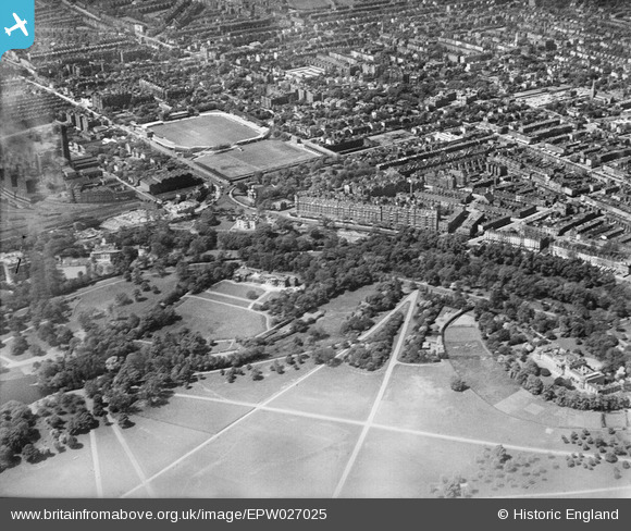
EPW027025 ENGLAND (1929). North Gate, Lord's Cricket Ground and Regent's Park, St John's Wood, 1929

© Copyright OpenStreetMap contributors and licensed by the OpenStreetMap Foundation. 2024. Cartography is licensed as CC BY-SA.

Nearby Images (10)

EPW027025
  0° 0m
EPW027026
  296° 55m
EPW027021
  295° 68m
EPW027023
  282° 71m
EPW027018
  238° 81m
EPW027024
  300° 99m
EPW027022
  291° 109m
EPW027020
  288° 117m
EPW027019
  289° 123m
EAW044242
  200° 261m

Details

Title [EPW027025] North Gate, Lord's Cricket Ground and Regent's Park, St John's Wood, 1929
Reference EPW027025
Date May-1929
Link
Place name ST JOHN'S WOOD
Parish
District
Country ENGLAND
Easting / Northing 527331, 182964
Longitude / Latitude -0.16411448781805, 51.530727798245
National Grid Reference TQ273830

Pins

Regent's Canal, 07/10/2014

Class31
Wednesday 8th of October 2014 02:00:40 PM
Regent's Park, 07/10/2014

Class31
Wednesday 8th of October 2014 01:59:44 PM
Regent's Park, 07/10/2014

Class31
Wednesday 8th of October 2014 01:58:51 PM
St John's Wood Church Garden, 07/10/2014

Class31
Wednesday 8th of October 2014 01:49:48 PM
Prince Albert Road, 07/10/2014

Class31
Wednesday 8th of October 2014 12:41:35 PM
St John's Wood Church 18/02/2014

Class31
Monday 3rd of March 2014 11:43:30 AM

User Comment Contributions

Regent's Canal, 07/10/2014

Class31
Wednesday 8th of October 2014 02:01:12 PM
St John's Wood Church and War Memorial by Charles Leonard Hartwell, 07/10/2014

Class31
Wednesday 8th of October 2014 01:48:56 PM
St John's Wood Church, 07/10/2014

Class31
Wednesday 8th of October 2014 12:42:07 PM