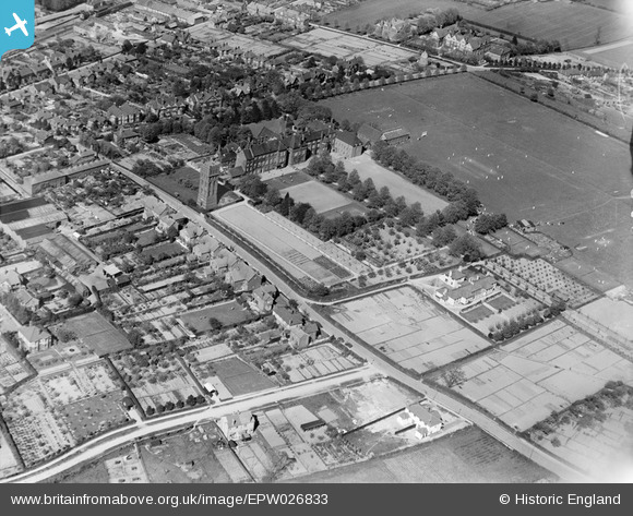
EPW026833 ENGLAND (1929). The Friends' School and environs, Saffron Walden, 1929
© Copyright OpenStreetMap contributors and licensed by the OpenStreetMap Foundation. 2026. Cartography is licensed as CC BY-SA.
Nearby Images (18)
Details
| Title | [EPW026833] The Friends' School and environs, Saffron Walden, 1929 |
| Reference | EPW026833 |
| Date | May-1929 |
| Link | |
| Place name | SAFFRON WALDEN |
| Parish | SAFFRON WALDEN |
| District | |
| Country | ENGLAND |
| Easting / Northing | 553914, 237597 |
| Longitude / Latitude | 0.2430960764615, 52.014999214337 |
| National Grid Reference | TL539376 |


![[EPW026833] The Friends' School and environs, Saffron Walden, 1929](http://britainfromabove.org.uk/sites/all/libraries/aerofilms-images/public/100x100/EPW/026/EPW026833.jpg)
![[EPW026817] The Friends' School, Saffron Walden, 1929](http://britainfromabove.org.uk/sites/all/libraries/aerofilms-images/public/100x100/EPW/026/EPW026817.jpg)
![[EPW026819] The Friends' School and environs, Saffron Walden, 1929](http://britainfromabove.org.uk/sites/all/libraries/aerofilms-images/public/100x100/EPW/026/EPW026819.jpg)
![[EPW025914] The Friends' School, Saffron Walden, 1929](http://britainfromabove.org.uk/sites/all/libraries/aerofilms-images/public/100x100/EPW/025/EPW025914.jpg)
![[EPW026829] Debden Road and the Friends' School, Saffron Walden, 1929](http://britainfromabove.org.uk/sites/all/libraries/aerofilms-images/public/100x100/EPW/026/EPW026829.jpg)
![[EPW026832] The Friends' School, Saffron Walden, 1929](http://britainfromabove.org.uk/sites/all/libraries/aerofilms-images/public/100x100/EPW/026/EPW026832.jpg)
![[EPW026830] The Friends' School, Saffron Walden, 1929](http://britainfromabove.org.uk/sites/all/libraries/aerofilms-images/public/100x100/EPW/026/EPW026830.jpg)
![[EPW026821] The Friends' School, Saffron Walden, 1929](http://britainfromabove.org.uk/sites/all/libraries/aerofilms-images/public/100x100/EPW/026/EPW026821.jpg)
![[EPW026820] The Friends' School and environs, Saffron Walden, 1929](http://britainfromabove.org.uk/sites/all/libraries/aerofilms-images/public/100x100/EPW/026/EPW026820.jpg)
![[EPW026826] The Friends' School, Saffron Walden, 1929](http://britainfromabove.org.uk/sites/all/libraries/aerofilms-images/public/100x100/EPW/026/EPW026826.jpg)
![[EPW026828] The Friends' School, Saffron Walden, 1929](http://britainfromabove.org.uk/sites/all/libraries/aerofilms-images/public/100x100/EPW/026/EPW026828.jpg)
![[EPW026818] The Friends' School and environs, Saffron Walden, 1929](http://britainfromabove.org.uk/sites/all/libraries/aerofilms-images/public/100x100/EPW/026/EPW026818.jpg)
![[EPW026824] Debden Road and the Friends' School, Saffron Walden, 1929](http://britainfromabove.org.uk/sites/all/libraries/aerofilms-images/public/100x100/EPW/026/EPW026824.jpg)
![[EPW026827] The Friends' School and environs, Saffron Walden, 1929](http://britainfromabove.org.uk/sites/all/libraries/aerofilms-images/public/100x100/EPW/026/EPW026827.jpg)
![[EPW026836] The Friends' School and environs, Saffron Walden, 1929](http://britainfromabove.org.uk/sites/all/libraries/aerofilms-images/public/100x100/EPW/026/EPW026836.jpg)
![[EPW026835] The Friends' School and environs, Saffron Walden, 1929](http://britainfromabove.org.uk/sites/all/libraries/aerofilms-images/public/100x100/EPW/026/EPW026835.jpg)
![[EPW026823] Debden Road and the Friends' School, Saffron Walden, 1929](http://britainfromabove.org.uk/sites/all/libraries/aerofilms-images/public/100x100/EPW/026/EPW026823.jpg)
![[EPW026831] The Friends' School and environs, Saffron Walden, 1929](http://britainfromabove.org.uk/sites/all/libraries/aerofilms-images/public/100x100/EPW/026/EPW026831.jpg)
