
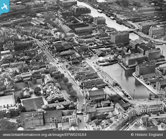
EPW024164 ENGLAND (1928). Victoria Dock, Southgate Street and environs, Gloucester, 1928
© Copyright OpenStreetMap contributors and licensed by the OpenStreetMap Foundation. 2026. Cartography is licensed as CC BY-SA.
Nearby Images (15)
EPW024164

EPW024166

EPW037751

EAW012204

EPW048244

EAW012200

EAW012202

EPW037834

EPW037750

EAW018730

EPW037749

EAW012207

EAW012197

EPW024161

EAW012209

Details
| Title | [EPW024164] Victoria Dock, Southgate Street and environs, Gloucester, 1928 |
| Reference | EPW024164 |
| Date | September-1928 |
| Link | |
| Place name | GLOUCESTER |
| Parish | |
| District | |
| Country | ENGLAND |
| Easting / Northing | 382847, 218200 |
| Longitude / Latitude | -2.2491167480927, 51.861677882628 |
| National Grid Reference | SO828182 |
Pins

Class31 |
Wednesday 29th of October 2014 01:30:07 PM | |
|
Class31 |
Monday 30th of September 2013 05:50:14 PM | |
|
Class31 |
Monday 30th of September 2013 05:47:28 PM | |

Onedytoo |
Wednesday 28th of August 2013 12:21:03 PM | |
|
Class31 |
Tuesday 16th of October 2012 12:56:38 PM | |
|
Class31 |
Tuesday 16th of October 2012 12:56:16 PM | |
|
Class31 |
Tuesday 16th of October 2012 12:54:18 PM | |
|
Class31 |
Tuesday 16th of October 2012 12:53:32 PM | |
|
Trebor |
Tuesday 28th of August 2012 10:01:15 AM | |
|
Trebor |
Tuesday 28th of August 2012 10:00:16 AM |


User Comment Contributions

Warehouses, Gloucester, 28/10/2014 |
Class31 |
Wednesday 29th of October 2014 01:32:14 PM |

Warehouses alonside Victoria Dock looking north 27/09/2013 |
Class31 |
Monday 30th of September 2013 05:51:36 PM |
Shows: * old hospital on southgate st * Kimbrose way as a tiny lane, with what's become know as Kimbrose triangle as a peninsula * st Owens and various frontage buildings adjacent on south gate st, including mercy lane? * tram lines on south gate st, cranes and chimneys and sidings in dock estate * atlas works etc south of llanthony rd (quays shopping centre site) * sidings at site of current gloscol buildings |
Ian Williams |
Saturday 30th of June 2012 09:18:06 AM |