
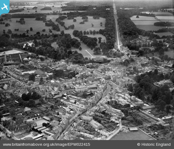
EPW022415 ENGLAND (1928). The Town Centre and Broad Ride, Cirencester, from the north-east, 1928
© Copyright OpenStreetMap contributors and licensed by the OpenStreetMap Foundation. 2026. Cartography is licensed as CC BY-SA.
Nearby Images (17)
EPW022415

EPW022417

EPW022413

EAW006877

EAW006878

EPW006310

EPW022410

EAW031681

EPW022409

EPW022416

EPW022412

EPW061778

EPW061780

EPW061775

EPW061776

EPW022407

EPW061777

Details
| Title | [EPW022415] The Town Centre and Broad Ride, Cirencester, from the north-east, 1928 |
| Reference | EPW022415 |
| Date | August-1928 |
| Link | |
| Place name | CIRENCESTER |
| Parish | CIRENCESTER |
| District | |
| Country | ENGLAND |
| Easting / Northing | 402447, 201988 |
| Longitude / Latitude | -1.9645758908833, 51.716156938073 |
| National Grid Reference | SP024020 |
Pins

Alan McFaden |
Wednesday 21st of May 2014 09:55:02 PM | |
|
Alan McFaden |
Wednesday 21st of May 2014 09:54:25 PM | |
Lynda Tubbs |
Thursday 13th of February 2014 02:13:14 PM | |

SydM |
Sunday 31st of March 2013 06:03:53 PM | |

Class31 |
Thursday 24th of January 2013 08:46:44 PM | |
|
Class31 |
Sunday 28th of October 2012 11:15:05 PM | |
|
Class31 |
Sunday 28th of October 2012 11:14:28 PM | |
|
Class31 |
Sunday 28th of October 2012 11:13:57 PM | |
|
Tetbury |
Wednesday 27th of June 2012 09:13:41 PM | |
|
Tetbury |
Wednesday 27th of June 2012 08:24:53 PM | |
|
dgeats |
Wednesday 27th of June 2012 01:44:45 PM | |
|
Tetbury |
Wednesday 27th of June 2012 01:32:45 AM |

