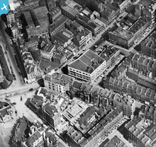
EPW016615 ENGLAND (1926). Euston Road at the junction with Osnaburgh Street, Marylebone, 1926
    © Copyright OpenStreetMap contributors and licensed by the OpenStreetMap Foundation. 2025. Cartography is licensed as CC BY-SA.
  
Nearby Images (12)
Details
| Title | [EPW016615] Euston Road at the junction with Osnaburgh Street, Marylebone, 1926 | 
| Reference | EPW016615 | 
| Date | August-1926 | 
| Link | |
| Place name | MARYLEBONE | 
| Parish | |
| District | |
| Country | ENGLAND | 
| Easting / Northing | 528953, 182160 | 
| Longitude / Latitude | -0.14103570215053, 51.523133483978 | 
| National Grid Reference | TQ290822 | 
Pins
|  Regents Place - Present Location |   picket08 | Thursday 14th of February 2013 06:42:27 PM | 
|  Great Portland Street Underground Station |   picket08 | Thursday 14th of February 2013 06:42:02 PM | 
|  Royal National Orthopeidic Hospital |   picket08 | Thursday 14th of February 2013 06:41:35 PM | 
|  Cleveland Street | Class31 | Monday 11th of February 2013 10:50:52 PM | 
|  Euston Road | Class31 | Monday 11th of February 2013 10:50:09 PM | 
|  Great Titchfield Street | Class31 | Monday 11th of February 2013 10:49:30 PM | 
|  Greenwell Street | Class31 | Monday 11th of February 2013 10:48:40 PM | 
|  Bolsover Street | Class31 | Monday 11th of February 2013 10:46:55 PM | 
|  Warren Street | Class31 | Monday 11th of February 2013 10:46:09 PM | 
|  Osnaburgh Street | Class31 | Monday 11th of February 2013 10:45:46 PM | 
 
             
  ![[EPW016615] Euston Road at the junction with Osnaburgh Street, Marylebone, 1926](http://britainfromabove.org.uk/sites/all/libraries/aerofilms-images/public/100x100/EPW/016/EPW016615.jpg) 
  
                                          ![[EPW015728] Euston Road and environs, Bloomsbury, 1926](http://britainfromabove.org.uk/sites/all/libraries/aerofilms-images/public/100x100/EPW/015/EPW015728.jpg) 
 ![[EPW015729] Regent's Park Square, Euston Road and environs, Bloomsbury, 1926](http://britainfromabove.org.uk/sites/all/libraries/aerofilms-images/public/100x100/EPW/015/EPW015729.jpg) 
 ![[EPW015722] Regent's Park and view towards St Pancras, Bloomsbury, from the west, 1926](http://britainfromabove.org.uk/sites/all/libraries/aerofilms-images/public/100x100/EPW/015/EPW015722.jpg) 
 ![[EPW015724] Euston Road and environs, Bloomsbury, 1926](http://britainfromabove.org.uk/sites/all/libraries/aerofilms-images/public/100x100/EPW/015/EPW015724.jpg) 
 ![[EPW015723] Euston Road and environs, Bloomsbury, 1926](http://britainfromabove.org.uk/sites/all/libraries/aerofilms-images/public/100x100/EPW/015/EPW015723.jpg) 
 ![[EPW016617] Holy Trinity Church, Great Portland Street underground station and the junction with Euston Road, Marylebone, 1926](http://britainfromabove.org.uk/sites/all/libraries/aerofilms-images/public/100x100/EPW/016/EPW016617.jpg) 
 ![[EPW015725] Euston Road and environs, Bloomsbury, 1926](http://britainfromabove.org.uk/sites/all/libraries/aerofilms-images/public/100x100/EPW/015/EPW015725.jpg) 
 ![[EPW016616] Holy Trinity Church and Great Portland Street underground station, Marylebone, 1926](http://britainfromabove.org.uk/sites/all/libraries/aerofilms-images/public/100x100/EPW/016/EPW016616.jpg) 
 ![[EPW016618] Holy Trinity Church, Great Portland Street underground station and the junction with Euston Road, Marylebone, 1926](http://britainfromabove.org.uk/sites/all/libraries/aerofilms-images/public/100x100/EPW/016/EPW016618.jpg) 
 ![[EPW015727] Osnaburgh Street and environs, Regent's Park, 1926](http://britainfromabove.org.uk/sites/all/libraries/aerofilms-images/public/100x100/EPW/015/EPW015727.jpg) 
 ![[EPW045397] Portland Place and environs, Marylebone, 1934](http://britainfromabove.org.uk/sites/all/libraries/aerofilms-images/public/100x100/EPW/045/EPW045397.jpg) 
 