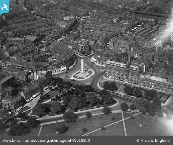
EPW016250 ENGLAND (1926). The War Memorial, Harrogate, 1926
© Copyright OpenStreetMap contributors and licensed by the OpenStreetMap Foundation. 2026. Cartography is licensed as CC BY-SA.
Nearby Images (17)
Details
| Title | [EPW016250] The War Memorial, Harrogate, 1926 |
| Reference | EPW016250 |
| Date | 14-July-1926 |
| Link | |
| Place name | HARROGATE |
| Parish | |
| District | |
| Country | ENGLAND |
| Easting / Northing | 430140, 455291 |
| Longitude / Latitude | -1.5402308896953, 53.992588587117 |
| National Grid Reference | SE301553 |
Pins
Lynda Tubbs |
Tuesday 19th of November 2013 01:05:24 PM | |
Allen T |
Sunday 11th of November 2012 07:10:41 PM | |
The tower was not built until 1926 |

aoxomoxoa |
Saturday 4th of October 2014 02:54:03 PM |


![[EPW016250] The War Memorial, Harrogate, 1926](http://britainfromabove.org.uk/sites/all/libraries/aerofilms-images/public/100x100/EPW/016/EPW016250.jpg)
![[EPW023552] Cambridge Crescent, Prospect Place and environs, Harrogate, 1928](http://britainfromabove.org.uk/sites/all/libraries/aerofilms-images/public/100x100/EPW/023/EPW023552.jpg)
![[EPW016246] The War Memorial, Harrogate, 1926](http://britainfromabove.org.uk/sites/all/libraries/aerofilms-images/public/100x100/EPW/016/EPW016246.jpg)
![[EPW015801] The town centre and war memorial, Harrogate, 1926](http://britainfromabove.org.uk/sites/all/libraries/aerofilms-images/public/100x100/EPW/015/EPW015801.jpg)
![[EPW043175] War Memorial, Harrogate, 1933](http://britainfromabove.org.uk/sites/all/libraries/aerofilms-images/public/100x100/EPW/043/EPW043175.jpg)
![[EPW043176] War Memorial, Harrogate, 1933](http://britainfromabove.org.uk/sites/all/libraries/aerofilms-images/public/100x100/EPW/043/EPW043176.jpg)
![[EPW015799] The town centre and war memorial, Harrogate, 1926](http://britainfromabove.org.uk/sites/all/libraries/aerofilms-images/public/100x100/EPW/015/EPW015799.jpg)
![[EPW043174] War Memorial, Harrogate, 1933](http://britainfromabove.org.uk/sites/all/libraries/aerofilms-images/public/100x100/EPW/043/EPW043174.jpg)
![[EPW023553] The Stray, war memorial and environs, Harrogate, 1928](http://britainfromabove.org.uk/sites/all/libraries/aerofilms-images/public/100x100/EPW/023/EPW023553.jpg)
![[EAW025655] The town, Harrogate, 1949. This image has been produced from a print.](http://britainfromabove.org.uk/sites/all/libraries/aerofilms-images/public/100x100/EAW/025/EAW025655.jpg)
![[EAW025654] The town, Harrogate, from the south-west, 1949. This image has been produced from a print.](http://britainfromabove.org.uk/sites/all/libraries/aerofilms-images/public/100x100/EAW/025/EAW025654.jpg)
![[EAW025649] Station Square, part of the Stray or Two Hundred Acre and environs, Harrogate, 1949. This image has been produced from a print.](http://britainfromabove.org.uk/sites/all/libraries/aerofilms-images/public/100x100/EAW/025/EAW025649.jpg)
![[EAW025652] The town, Harrogate, 1949](http://britainfromabove.org.uk/sites/all/libraries/aerofilms-images/public/100x100/EAW/025/EAW025652.jpg)
![[EAW025651] Prospect Square and environs, Harrogate, 1949. This image has been produced from a print.](http://britainfromabove.org.uk/sites/all/libraries/aerofilms-images/public/100x100/EAW/025/EAW025651.jpg)
![[EAW025648] The town, Harrogate, 1949. This image has been produced from a print.](http://britainfromabove.org.uk/sites/all/libraries/aerofilms-images/public/100x100/EAW/025/EAW025648.jpg)
![[EPW043182] Harrogate, 1933](http://britainfromabove.org.uk/sites/all/libraries/aerofilms-images/public/100x100/EPW/043/EPW043182.jpg)
![[EPW043183] Harrogate, 1933](http://britainfromabove.org.uk/sites/all/libraries/aerofilms-images/public/100x100/EPW/043/EPW043183.jpg)