
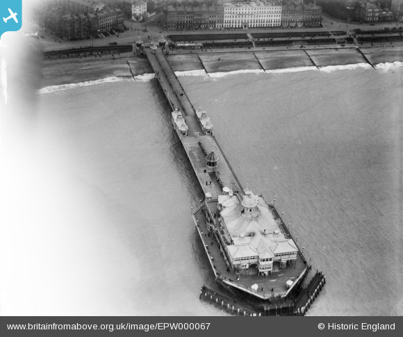
EPW000067 ENGLAND (1920). Eastbourne Pier, Eastbourne, 1920
© Copyright OpenStreetMap contributors and licensed by the OpenStreetMap Foundation. 2026. Cartography is licensed as CC BY-SA.
Nearby Images (13)
EPW000067

EPW035324

EPW000746

EAW006146

EAW022970

EPW035322

EPW000103

EAW022967

EPW039415

EPW000099

EPW000742

EPW000743

EPW039403

Details
| Title | [EPW000067] Eastbourne Pier, Eastbourne, 1920 |
| Reference | EPW000067 |
| Date | February-1920 |
| Link | |
| Place name | EASTBOURNE |
| Parish | |
| District | |
| Country | ENGLAND |
| Easting / Northing | 561887, 98817 |
| Longitude / Latitude | 0.29588496347194, 50.765757008298 |
| National Grid Reference | TV619988 |
Pins

Alan McFaden |
Monday 22nd of July 2013 06:44:25 PM | |
|
Alan McFaden |
Monday 22nd of July 2013 06:43:50 PM | |
|
Alan McFaden |
Monday 22nd of July 2013 06:43:10 PM | |
|
Alan McFaden |
Monday 22nd of July 2013 06:42:43 PM | |
|
Alan McFaden |
Monday 22nd of July 2013 06:42:13 PM |


User Comment Contributions
Agree with Eastbourne26 about the reverse image. The many windowed white building is the Burlington Hotel. The Claremont Hotel now adjoins it. When the shot was taken, the Burlington did not extend to the junction with Terminus Road (then Victoria Place). They gradually bought up the properties to enlarge the hotel. |

Mikeo1938 |
Wednesday 27th of June 2012 06:43:45 PM |
Great picture, but I believe that this is a reverse image. The many windowed white building should be on the left. |
Eastbourne26 |
Monday 25th of June 2012 07:23:23 PM |