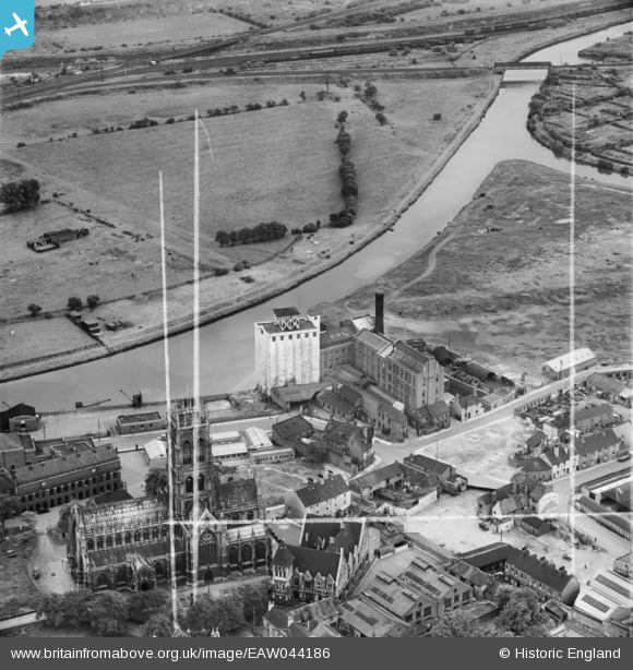
EAW044186 ENGLAND (1952). The Thomas Hanley and Sons Ltd (J. Rank Ltd) Flour Mill, St George's Church and environs, Doncaster, 1952. This image was marked by Aerofilms Ltd for photo editing.
© Copyright OpenStreetMap contributors and licensed by the OpenStreetMap Foundation. 2026. Cartography is licensed as CC BY-SA.
Nearby Images (25)
Details
| Title | [EAW044186] The Thomas Hanley and Sons Ltd (J. Rank Ltd) Flour Mill, St George's Church and environs, Doncaster, 1952. This image was marked by Aerofilms Ltd for photo editing. |
| Reference | EAW044186 |
| Date | 23-June-1952 |
| Link | |
| Place name | DONCASTER |
| Parish | |
| District | |
| Country | ENGLAND |
| Easting / Northing | 457458, 403694 |
| Longitude / Latitude | -1.1331540961718, 53.526516922976 |
| National Grid Reference | SE575037 |
Pins
Be the first to add a comment to this image!


![[EAW044186] The Thomas Hanley and Sons Ltd (J. Rank Ltd) Flour Mill, St George's Church and environs, Doncaster, 1952. This image was marked by Aerofilms Ltd for photo editing.](http://britainfromabove.org.uk/sites/all/libraries/aerofilms-images/public/100x100/EAW/044/EAW044186.jpg)
![[EAW044181] The Thomas Hanley and Sons Ltd (J. Rank Ltd) Flour Mill and environs, Doncaster, 1952. This image was marked by Aerofilms Ltd for photo editing.](http://britainfromabove.org.uk/sites/all/libraries/aerofilms-images/public/100x100/EAW/044/EAW044181.jpg)
![[EAW044185] The Thomas Hanley and Sons Ltd (J. Rank Ltd) Flour Mill and environs, Doncaster, 1952. This image was marked by Aerofilms Ltd for photo editing.](http://britainfromabove.org.uk/sites/all/libraries/aerofilms-images/public/100x100/EAW/044/EAW044185.jpg)
![[EPW012757] Hanley and Sons Corn Mill, Doncaster, 1925](http://britainfromabove.org.uk/sites/all/libraries/aerofilms-images/public/100x100/EPW/012/EPW012757.jpg)
![[EAW044179] The Thomas Hanley and Sons Ltd (J. Rank Ltd) Flour Mill and St George's Church, Doncaster, 1952. This image was marked by Aerofilms Ltd for photo editing.](http://britainfromabove.org.uk/sites/all/libraries/aerofilms-images/public/100x100/EAW/044/EAW044179.jpg)
![[EAW044182] The Thomas Hanley and Sons Ltd (J. Rank Ltd) Flour Mill and St George's Church, Doncaster, 1952. This image was marked by Aerofilms Ltd for photo editing.](http://britainfromabove.org.uk/sites/all/libraries/aerofilms-images/public/100x100/EAW/044/EAW044182.jpg)
![[EAW044184] The Thomas Hanley and Sons Ltd (J. Rank Ltd) Flour Mill and St George's Church, Doncaster, 1952. This image was marked by Aerofilms Ltd for photo editing.](http://britainfromabove.org.uk/sites/all/libraries/aerofilms-images/public/100x100/EAW/044/EAW044184.jpg)
![[EAW043790] Hanley's Flour Mills, St George's Church and environs, Doncaster, 1952. This image was marked by Aerofilms Ltd for photo editing.](http://britainfromabove.org.uk/sites/all/libraries/aerofilms-images/public/100x100/EAW/043/EAW043790.jpg)
![[EAW043785] Hanley's Flour Mills beside the River Don New Cut, Doncaster, 1952. This image was marked by Aerofilms Ltd for photo editing.](http://britainfromabove.org.uk/sites/all/libraries/aerofilms-images/public/100x100/EAW/043/EAW043785.jpg)
![[EAW044180] The Thomas Hanley and Sons Ltd (J. Rank Ltd) Flour Mill and environs, Doncaster, 1952. This image was marked by Aerofilms Ltd for photo editing.](http://britainfromabove.org.uk/sites/all/libraries/aerofilms-images/public/100x100/EAW/044/EAW044180.jpg)
![[EAW043792] Hanley's Flour Mills and St George's Church, Doncaster, 1952. This image was marked by Aerofilms Ltd for photo editing.](http://britainfromabove.org.uk/sites/all/libraries/aerofilms-images/public/100x100/EAW/043/EAW043792.jpg)
![[EAW044183] The Thomas Hanley and Sons Ltd (J. Rank Ltd) Flour Mill and St George's Church, Doncaster, 1952. This image was marked by Aerofilms Ltd for photo editing.](http://britainfromabove.org.uk/sites/all/libraries/aerofilms-images/public/100x100/EAW/044/EAW044183.jpg)
![[EAW044178] The Thomas Hanley and Sons Ltd (J. Rank Ltd) Flour Mill and environs, Doncaster, 1952. This image was marked by Aerofilms Ltd for photo editing.](http://britainfromabove.org.uk/sites/all/libraries/aerofilms-images/public/100x100/EAW/044/EAW044178.jpg)
![[EAW043787] Hanley's Flour Mills beside the River Don New Cut, Doncaster, 1952. This image was marked by Aerofilms Ltd for photo editing.](http://britainfromabove.org.uk/sites/all/libraries/aerofilms-images/public/100x100/EAW/043/EAW043787.jpg)
![[EAW043789] Hanley's Flour Mills, St George's Church and environs, Doncaster, 1952. This image was marked by Aerofilms Ltd for photo editing.](http://britainfromabove.org.uk/sites/all/libraries/aerofilms-images/public/100x100/EAW/043/EAW043789.jpg)
![[EAW043788] Hanley's Flour Mills, St George's Church and environs, Doncaster, 1952. This image was marked by Aerofilms Ltd for photo editing.](http://britainfromabove.org.uk/sites/all/libraries/aerofilms-images/public/100x100/EAW/043/EAW043788.jpg)
![[EPW061934] High Fishergate and environs, Doncaster, 1939](http://britainfromabove.org.uk/sites/all/libraries/aerofilms-images/public/100x100/EPW/061/EPW061934.jpg)
![[EAW043786] Hanley's Flour Mills beside the River Don New Cut, Doncaster, 1952. This image was marked by Aerofilms Ltd for photo editing.](http://britainfromabove.org.uk/sites/all/libraries/aerofilms-images/public/100x100/EAW/043/EAW043786.jpg)
![[EAW043791] Hanley's Flour Mills and the Cattle Market, Doncaster, 1952. This image was marked by Aerofilms Ltd for photo editing.](http://britainfromabove.org.uk/sites/all/libraries/aerofilms-images/public/100x100/EAW/043/EAW043791.jpg)
![[EPW012772] St George's Church, Doncaster, 1925](http://britainfromabove.org.uk/sites/all/libraries/aerofilms-images/public/100x100/EPW/012/EPW012772.jpg)
![[EPW061932] Friary Closes, Doncaster, 1939](http://britainfromabove.org.uk/sites/all/libraries/aerofilms-images/public/100x100/EPW/061/EPW061932.jpg)
![[EPW061937] The Cattle Market and environs, Doncaster, 1939](http://britainfromabove.org.uk/sites/all/libraries/aerofilms-images/public/100x100/EPW/061/EPW061937.jpg)
![[EPW012767] St George's Church, Doncaster, 1925. This image has been produced from a copy-negative.](http://britainfromabove.org.uk/sites/all/libraries/aerofilms-images/public/100x100/EPW/012/EPW012767.jpg)
![[EPW012764] North Bridge Road, the River Don and the town centre, Doncaster, 1925. This image has been produced from a copy-negative.](http://britainfromabove.org.uk/sites/all/libraries/aerofilms-images/public/100x100/EPW/012/EPW012764.jpg)
![[EPW012776] The Market Hall and Corn Exchange, Doncaster, 1925](http://britainfromabove.org.uk/sites/all/libraries/aerofilms-images/public/100x100/EPW/012/EPW012776.jpg)