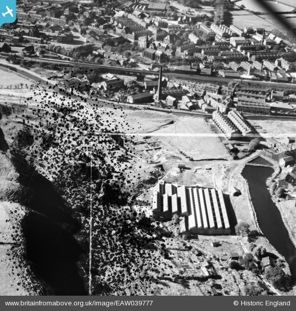
EAW039777 ENGLAND (1951). Ealees Mill, Littleborough, 1951. This image has been produced from a damaged negative.
© Copyright OpenStreetMap contributors and licensed by the OpenStreetMap Foundation. 2025. Cartography is licensed as CC BY-SA.
Nearby Images (8)
Details
| Title | [EAW039777] Ealees Mill, Littleborough, 1951. This image has been produced from a damaged negative. |
| Reference | EAW039777 |
| Date | 15-September-1951 |
| Link | |
| Place name | LITTLEBOROUGH |
| Parish | |
| District | |
| Country | ENGLAND |
| Easting / Northing | 394122, 416253 |
| Longitude / Latitude | -2.0889212102082, 53.642522970727 |
| National Grid Reference | SD941163 |
Pins

ssShaunW1 |
Tuesday 29th of December 2020 05:59:26 PM |


![[EAW039777] Ealees Mill, Littleborough, 1951. This image has been produced from a damaged negative.](http://britainfromabove.org.uk/sites/all/libraries/aerofilms-images/public/100x100/EAW/039/EAW039777.jpg)
![[EAW039772] Ealees Mill, Littleborough, 1951. This image has been produced from a damaged negative.](http://britainfromabove.org.uk/sites/all/libraries/aerofilms-images/public/100x100/EAW/039/EAW039772.jpg)
![[EAW039776] Ealees Mill and Durn Mill, Littleborough, 1951. This image has been produced from a damaged negative.](http://britainfromabove.org.uk/sites/all/libraries/aerofilms-images/public/100x100/EAW/039/EAW039776.jpg)
![[EAW039773] Ealees Mill, Littleborough, 1951. This image has been produced from a damaged negative.](http://britainfromabove.org.uk/sites/all/libraries/aerofilms-images/public/100x100/EAW/039/EAW039773.jpg)
![[EAW039779] Ealees Mill, Littleborough, 1951. This image was marked by Aerofilms Ltd for photo editing.](http://britainfromabove.org.uk/sites/all/libraries/aerofilms-images/public/100x100/EAW/039/EAW039779.jpg)
![[EAW039774] Ealees Mill, Littleborough, 1951. This image has been produced from a damaged negative.](http://britainfromabove.org.uk/sites/all/libraries/aerofilms-images/public/100x100/EAW/039/EAW039774.jpg)
![[EAW039775] Ealees Mill, Littleborough, 1951. This image has been produced from a damaged negative.](http://britainfromabove.org.uk/sites/all/libraries/aerofilms-images/public/100x100/EAW/039/EAW039775.jpg)
![[EAW039778] Ealees Mill, Littleborough, 1951. This image has been produced from a damaged negative.](http://britainfromabove.org.uk/sites/all/libraries/aerofilms-images/public/100x100/EAW/039/EAW039778.jpg)