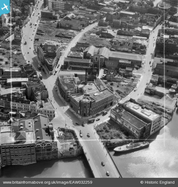
EAW032259 ENGLAND (1950). Victoria Street, the E. S. & A. Robinson Premises on Redcliff Street and environs, 1950. This image was marked by Aerofilms Ltd for photo editing.
© Copyright OpenStreetMap contributors and licensed by the OpenStreetMap Foundation. 2026. Cartography is licensed as CC BY-SA.
Nearby Images (35)
Details
| Title | [EAW032259] Victoria Street, the E. S. & A. Robinson Premises on Redcliff Street and environs, 1950. This image was marked by Aerofilms Ltd for photo editing. |
| Reference | EAW032259 |
| Date | 5-September-1950 |
| Link | |
| Place name | BRISTOL |
| Parish | |
| District | |
| Country | ENGLAND |
| Easting / Northing | 359074, 172823 |
| Longitude / Latitude | -2.5890493272065, 51.452420008789 |
| National Grid Reference | ST591728 |
Pins

Braikenridge |
Tuesday 22nd of April 2014 06:11:29 PM |


![[EAW032259] Victoria Street, the E. S. & A. Robinson Premises on Redcliff Street and environs, 1950. This image was marked by Aerofilms Ltd for photo editing.](http://britainfromabove.org.uk/sites/all/libraries/aerofilms-images/public/100x100/EAW/032/EAW032259.jpg)
![[EAW032254] Victoria Street, the E. S. & A. Robinson Premises on Redcliff Street and environs, 1950. This image was marked by Aerofilms Ltd for photo editing.](http://britainfromabove.org.uk/sites/all/libraries/aerofilms-images/public/100x100/EAW/032/EAW032254.jpg)
![[EAW032258] Victoria Street, the E. S. & A. Robinson Premises on Redcliff Street and environs, 1950. This image was marked by Aerofilms Ltd for photo editing.](http://britainfromabove.org.uk/sites/all/libraries/aerofilms-images/public/100x100/EAW/032/EAW032258.jpg)
![[EAW032257] Victoria Street, Redcliff Street and environs, Bristol, 1950. This image was marked by Aerofilms Ltd for photo editing.](http://britainfromabove.org.uk/sites/all/libraries/aerofilms-images/public/100x100/EAW/032/EAW032257.jpg)
![[EAW032256] Bath Street, Victoria Street and Redcliff Street, Bristol, 1950. This image was marked by Aerofilms Ltd for photo editing.](http://britainfromabove.org.uk/sites/all/libraries/aerofilms-images/public/100x100/EAW/032/EAW032256.jpg)
![[EPW038304] Victoria Street, George's Brewey and the W.B. Harris Print Works, Bristol, 1932](http://britainfromabove.org.uk/sites/all/libraries/aerofilms-images/public/100x100/EPW/038/EPW038304.jpg)
![[EAW032261] Redcliff Street, the Church of St Thomas the Martyr and environs, Bristol, 1950. This image was marked by Aerofilms Ltd for photo editing.](http://britainfromabove.org.uk/sites/all/libraries/aerofilms-images/public/100x100/EAW/032/EAW032261.jpg)
![[EPW038303] Industry around the Bristol Bridge, Bristol, 1932](http://britainfromabove.org.uk/sites/all/libraries/aerofilms-images/public/100x100/EPW/038/EPW038303.jpg)
![[EAW032260] Victoria Street, Redcliff Street and Bristol Bridge, Bristol, 1950. This image was marked by Aerofilms Ltd for photo editing.](http://britainfromabove.org.uk/sites/all/libraries/aerofilms-images/public/100x100/EAW/032/EAW032260.jpg)
![[EAW032255] Victoria Street, Redcliff Street and Bristol Bridge, Bristol, 1950. This image was marked by Aerofilms Ltd for photo editing.](http://britainfromabove.org.uk/sites/all/libraries/aerofilms-images/public/100x100/EAW/032/EAW032255.jpg)
![[EPW034455] Victoria Street and Works off Bath Street, Bristol, 1930](http://britainfromabove.org.uk/sites/all/libraries/aerofilms-images/public/100x100/EPW/034/EPW034455.jpg)
![[EPW038300] George's Brewery and Bristol Bridge, Bristol, 1932](http://britainfromabove.org.uk/sites/all/libraries/aerofilms-images/public/100x100/EPW/038/EPW038300.jpg)
![[EPW038302] Industry around the Bristol Bridge, Bristol, 1932](http://britainfromabove.org.uk/sites/all/libraries/aerofilms-images/public/100x100/EPW/038/EPW038302.jpg)
![[EPW038301] Industry around the Bristol Bridge, Bristol, 1932](http://britainfromabove.org.uk/sites/all/libraries/aerofilms-images/public/100x100/EPW/038/EPW038301.jpg)
![[EPW034452] George's Brewey, the Tramway Generating Station and Victoria Street, Bristol, 1930](http://britainfromabove.org.uk/sites/all/libraries/aerofilms-images/public/100x100/EPW/034/EPW034452.jpg)
![[EPW033498] Bristol Bridge and the city, Bristol, 1930](http://britainfromabove.org.uk/sites/all/libraries/aerofilms-images/public/100x100/EPW/033/EPW033498.jpg)
![[EPW034460] Bennett's Counterslip Works (Printing and Stationery) and the Tramway Generating Station, Bristol, 1930](http://britainfromabove.org.uk/sites/all/libraries/aerofilms-images/public/100x100/EPW/034/EPW034460.jpg)
![[EPW034458] Victoria Street and Temple Street and environs, Bristol, 1930](http://britainfromabove.org.uk/sites/all/libraries/aerofilms-images/public/100x100/EPW/034/EPW034458.jpg)
![[EPW034453] George's Brewey, the Tramway Generating Station and Temple Street, Bristol, 1930](http://britainfromabove.org.uk/sites/all/libraries/aerofilms-images/public/100x100/EPW/034/EPW034453.jpg)
![[EPW034459] Bennett's Counterslip Works (Printing and Stationery) and the Tramway Generating Station, Bristol, 1930](http://britainfromabove.org.uk/sites/all/libraries/aerofilms-images/public/100x100/EPW/034/EPW034459.jpg)
![[EPW008821] Redcliffe Wharf and Queen Square, Bristol, 1923](http://britainfromabove.org.uk/sites/all/libraries/aerofilms-images/public/100x100/EPW/008/EPW008821.jpg)
![[EPW034454] George's Brewery, Bennett's Counterslip Works (Print and Stationey) and the Tramway Generating Station, Bristol, 1930](http://britainfromabove.org.uk/sites/all/libraries/aerofilms-images/public/100x100/EPW/034/EPW034454.jpg)
![[EPW008826] Redcliffe Wharf and Queen Square, Bristol, 1923](http://britainfromabove.org.uk/sites/all/libraries/aerofilms-images/public/100x100/EPW/008/EPW008826.jpg)
![[EPW034457] St Philip's Bridge, Works off Bath Street and environs, Bristol, 1930](http://britainfromabove.org.uk/sites/all/libraries/aerofilms-images/public/100x100/EPW/034/EPW034457.jpg)
![[EPW008823] Redcliffe Wharf, Bristol, 1923](http://britainfromabove.org.uk/sites/all/libraries/aerofilms-images/public/100x100/EPW/008/EPW008823.jpg)
![[EPW008825] Redcliffe Wharf, Bristol, 1923](http://britainfromabove.org.uk/sites/all/libraries/aerofilms-images/public/100x100/EPW/008/EPW008825.jpg)
![[EPR000072] Baldwin Street, Bristol Bridge and the city centre, Bristol, 1934](http://britainfromabove.org.uk/sites/all/libraries/aerofilms-images/public/100x100/EPR/000/EPR000072.jpg)
![[EPW034451] Tramway Generating Station at Philip Street and the area around St Philip's Bridge and Bristol Bridge, Bristol, 1930](http://britainfromabove.org.uk/sites/all/libraries/aerofilms-images/public/100x100/EPW/034/EPW034451.jpg)
![[EPW008826A] Redcliffe Wharf, Bristol, 1923](http://britainfromabove.org.uk/sites/all/libraries/aerofilms-images/public/100x100/EPW/008/EPW008826A.jpg)
![[EPW008822] Redcliffe Wharf and Queen Square, Bristol, 1923](http://britainfromabove.org.uk/sites/all/libraries/aerofilms-images/public/100x100/EPW/008/EPW008822.jpg)
![[EPW008819] Redcliffe Wharf, Bristol, 1923](http://britainfromabove.org.uk/sites/all/libraries/aerofilms-images/public/100x100/EPW/008/EPW008819.jpg)
![[EPW008820] Redcliffe Wharf and Queen Square, Bristol, 1923](http://britainfromabove.org.uk/sites/all/libraries/aerofilms-images/public/100x100/EPW/008/EPW008820.jpg)
![[EPW034450] Tramway Generating Station at Philip Street and the area around St Philip's Bridge and Bristol Bridge, Bristol, 1930](http://britainfromabove.org.uk/sites/all/libraries/aerofilms-images/public/100x100/EPW/034/EPW034450.jpg)
![[EAW026795] Queen Square and the city centre, Bristol, from the south-west, 1949](http://britainfromabove.org.uk/sites/all/libraries/aerofilms-images/public/100x100/EAW/026/EAW026795.jpg)
![[EPW034456] Tramway Generating Station at Philip Street and the area around St Philip's Bridge and Bristol Bridge, Bristol, 1930](http://britainfromabove.org.uk/sites/all/libraries/aerofilms-images/public/100x100/EPW/034/EPW034456.jpg)