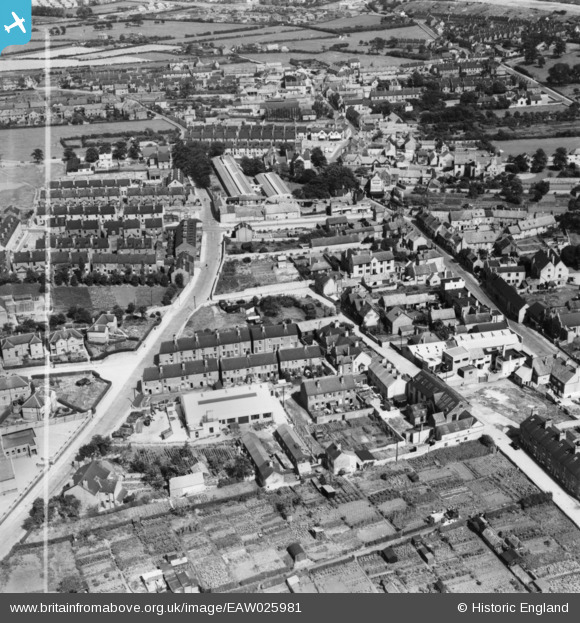
EAW025981 ENGLAND (1949). Oxclose Lane and environs, Mansfield Woodhouse, 1949. This image has been produced from a print marked by Aerofilms Ltd for photo editing.
© Copyright OpenStreetMap contributors and licensed by the OpenStreetMap Foundation. 2026. Cartography is licensed as CC BY-SA.
Nearby Images (7)
Details
| Title | [EAW025981] Oxclose Lane and environs, Mansfield Woodhouse, 1949. This image has been produced from a print marked by Aerofilms Ltd for photo editing. |
| Reference | EAW025981 |
| Date | 13-August-1949 |
| Link | |
| Place name | MANSFIELD WOODHOUSE |
| Parish | |
| District | |
| Country | ENGLAND |
| Easting / Northing | 453783, 363373 |
| Longitude / Latitude | -1.1954435780774, 53.164468570844 |
| National Grid Reference | SK538634 |


![[EAW025981] Oxclose Lane and environs, Mansfield Woodhouse, 1949. This image has been produced from a print marked by Aerofilms Ltd for photo editing.](http://britainfromabove.org.uk/sites/all/libraries/aerofilms-images/public/100x100/EAW/025/EAW025981.jpg)
![[EAW025976] Oxclose Lane, the N.J. Muschamp and Co Mining Engineering Works and environs, Mansfield Woodhouse, 1949. This image has been produced from a print marked by Aerofilms Ltd for photo editing.](http://britainfromabove.org.uk/sites/all/libraries/aerofilms-images/public/100x100/EAW/025/EAW025976.jpg)
![[EAW025977] Grove Street and environs, Mansfield Woodhouse, 1949. This image has been produced from a print marked by Aerofilms Ltd for photo editing.](http://britainfromabove.org.uk/sites/all/libraries/aerofilms-images/public/100x100/EAW/025/EAW025977.jpg)
![[EAW025975] The N.J. Muschamp and Co Mining Engineering Works and environs, Mansfield Woodhouse, 1949. This image has been produced from a print marked by Aerofilms Ltd for photo editing.](http://britainfromabove.org.uk/sites/all/libraries/aerofilms-images/public/100x100/EAW/025/EAW025975.jpg)
![[EAW025979] Grove Street and environs, Mansfield Woodhouse, 1949. This image has been produced from a print marked by Aerofilms Ltd for photo editing.](http://britainfromabove.org.uk/sites/all/libraries/aerofilms-images/public/100x100/EAW/025/EAW025979.jpg)
![[EAW025978] Grove Street and environs, Mansfield Woodhouse, 1949. This image has been produced from a print marked by Aerofilms Ltd for photo editing.](http://britainfromabove.org.uk/sites/all/libraries/aerofilms-images/public/100x100/EAW/025/EAW025978.jpg)
![[EAW025980] Grove Street and environs, Mansfield Woodhouse, 1949. This image has been produced from a print marked by Aerofilms Ltd for photo editing.](http://britainfromabove.org.uk/sites/all/libraries/aerofilms-images/public/100x100/EAW/025/EAW025980.jpg)
