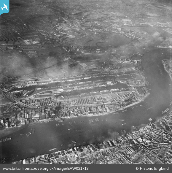
EAW021713 ENGLAND (1949). The Royal Albert Dock and the King George V Dock, North Woolwich, 1949. This image has been produced from a print.
© Copyright OpenStreetMap contributors and licensed by the OpenStreetMap Foundation. 2026. Cartography is licensed as CC BY-SA.
Nearby Images (23)
Details
| Title | [EAW021713] The Royal Albert Dock and the King George V Dock, North Woolwich, 1949. This image has been produced from a print. |
| Reference | EAW021713 |
| Date | 26-March-1949 |
| Link | |
| Place name | NORTH WOOLWICH |
| Parish | |
| District | |
| Country | ENGLAND |
| Easting / Northing | 543049, 180555 |
| Longitude / Latitude | 0.061383836895778, 51.505315135413 |
| National Grid Reference | TQ430806 |
Pins
Be the first to add a comment to this image!


![[EAW021713] The Royal Albert Dock and the King George V Dock, North Woolwich, 1949. This image has been produced from a print.](http://britainfromabove.org.uk/sites/all/libraries/aerofilms-images/public/100x100/EAW/021/EAW021713.jpg)
![[EAW021704] The Royal Albert Dock and the King George V Dock, North Woolwich, 1949. This image has been produced from a print.](http://britainfromabove.org.uk/sites/all/libraries/aerofilms-images/public/100x100/EAW/021/EAW021704.jpg)
![[EAW000037] The King George V Dock and the Royal Albert Dock, Beckton, 1946. This image has been produced from a damaged negative.](http://britainfromabove.org.uk/sites/all/libraries/aerofilms-images/public/100x100/EAW/000/EAW000037.jpg)
![[EAW008727] The Royal Albert Dock and the King George V Dock, North Woolwich, 1947](http://britainfromabove.org.uk/sites/all/libraries/aerofilms-images/public/100x100/EAW/008/EAW008727.jpg)
![[EPW032937] The Royal Albert Dock and King George V Dock, North Woolwich, 1930](http://britainfromabove.org.uk/sites/all/libraries/aerofilms-images/public/100x100/EPW/032/EPW032937.jpg)
![[EPW010729] Ships moored in the Royal Albert Dock and the King George V Dock, North Woolwich, 1924. This image has been produced from a print.](http://britainfromabove.org.uk/sites/all/libraries/aerofilms-images/public/100x100/EPW/010/EPW010729.jpg)
![[EAW021703] The Royal Albert Dock and the King George V Dock, North Woolwich, 1949. This image has been produced from a print.](http://britainfromabove.org.uk/sites/all/libraries/aerofilms-images/public/100x100/EAW/021/EAW021703.jpg)
![[EAW008725] The Royal Albert Dock and the King George V Dock, North Woolwich, 1947](http://britainfromabove.org.uk/sites/all/libraries/aerofilms-images/public/100x100/EAW/008/EAW008725.jpg)
![[EPW010727] Ships moored in the Royal Albert Dock and the King George V Dock, North Woolwich, 1924. This image has been produced from a copy-negative.](http://britainfromabove.org.uk/sites/all/libraries/aerofilms-images/public/100x100/EPW/010/EPW010727.jpg)
![[EAW021702] The Royal Albert Dock and the King George V Dock, North Woolwich, 1949. This image has been produced from a print.](http://britainfromabove.org.uk/sites/all/libraries/aerofilms-images/public/100x100/EAW/021/EAW021702.jpg)
![[EAW022354] The Royal Albert and King George V Docks, North Woolwich, 1949](http://britainfromabove.org.uk/sites/all/libraries/aerofilms-images/public/100x100/EAW/022/EAW022354.jpg)
![[EPW005310] Royal Albert Docks, Custom House, 1921](http://britainfromabove.org.uk/sites/all/libraries/aerofilms-images/public/100x100/EPW/005/EPW005310.jpg)
![[EPW032936] The Royal Albert Dock and King George V Dock, North Woolwich, 1930](http://britainfromabove.org.uk/sites/all/libraries/aerofilms-images/public/100x100/EPW/032/EPW032936.jpg)
![[EPW044119] The Royal Albert Dock, King George V Dock and the River Thames, East Ham, 1934](http://britainfromabove.org.uk/sites/all/libraries/aerofilms-images/public/100x100/EPW/044/EPW044119.jpg)
![[EPW021370] The Royal Albert and King George V Docks, North Woolwich, 1928](http://britainfromabove.org.uk/sites/all/libraries/aerofilms-images/public/100x100/EPW/021/EPW021370.jpg)
![[EAW022359] The Royal Docks and environs, North Woolwich, 1949](http://britainfromabove.org.uk/sites/all/libraries/aerofilms-images/public/100x100/EAW/022/EAW022359.jpg)
![[EAW022357] The Royal Albert and King George V Docks, North Woolwich, 1949](http://britainfromabove.org.uk/sites/all/libraries/aerofilms-images/public/100x100/EAW/022/EAW022357.jpg)
![[EAW005289] The Royal Albert Dock, King George V Dock and environs, North Woolwich, from the south-east, 1947](http://britainfromabove.org.uk/sites/all/libraries/aerofilms-images/public/100x100/EAW/005/EAW005289.jpg)
![[EAW000057] The Royal Victoria Dock, the Royal Albert Dock and the King George V Dock, North Woolwich, 1946. This image was produced from a print.](http://britainfromabove.org.uk/sites/all/libraries/aerofilms-images/public/100x100/EAW/000/EAW000057.jpg)
![[EAW000058] The King George V Dock and the Royal Albert Dock, Beckton, 1946. This image has been produced from a damaged negative.](http://britainfromabove.org.uk/sites/all/libraries/aerofilms-images/public/100x100/EAW/000/EAW000058.jpg)
![[EAW008726] The Royal Albert Dock and the King George V Dock, North Woolwich, 1947](http://britainfromabove.org.uk/sites/all/libraries/aerofilms-images/public/100x100/EAW/008/EAW008726.jpg)
![[EAW000035] The King George V Dock and the Royal Albert Dock, Beckton, 1946](http://britainfromabove.org.uk/sites/all/libraries/aerofilms-images/public/100x100/EAW/000/EAW000035.jpg)
![[EAW000054] The King George V Dock and the Royal Albert Dock, Beckton, 1946](http://britainfromabove.org.uk/sites/all/libraries/aerofilms-images/public/100x100/EAW/000/EAW000054.jpg)