
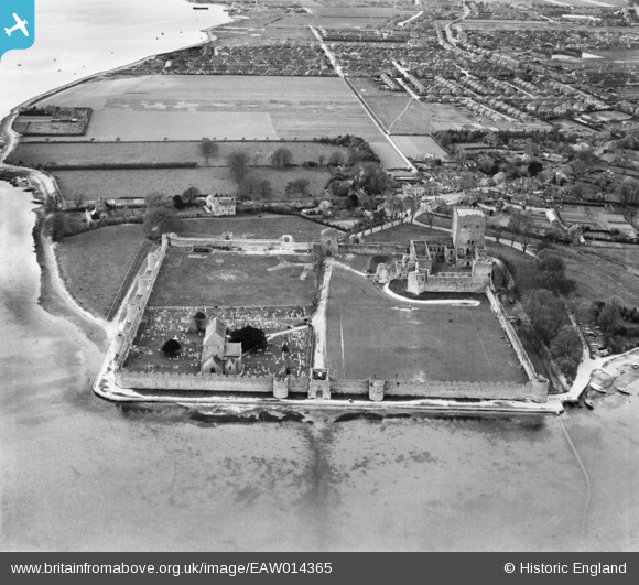
EAW014365 ENGLAND (1948). Portchester Castle and St Mary's Church, Portchester, 1948
© Copyright OpenStreetMap contributors and licensed by the OpenStreetMap Foundation. 2025. Cartography is licensed as CC BY-SA.
Nearby Images (10)
EAW014365

EAW005097

EAW005096

EAW005098

EAW014368

EAW014364

EAW014367

EAW005095

EAW005094

EAW014366

Details
| Title | [EAW014365] Portchester Castle and St Mary's Church, Portchester, 1948 |
| Reference | EAW014365 |
| Date | 13-April-1948 |
| Link | |
| Place name | PORTCHESTER |
| Parish | |
| District | |
| Country | ENGLAND |
| Easting / Northing | 462415, 104575 |
| Longitude / Latitude | -1.1135264836591, 50.836774899032 |
| National Grid Reference | SU624046 |
Pins
Be the first to add a comment to this image!
User Comment Contributions

Portchester Castle, 04/08/2015 |

Class31 |
Wednesday 5th of August 2015 04:16:30 PM |

Portchester Castle, 04/08/2015 |
Class31 |
Wednesday 5th of August 2015 04:11:29 PM |
The castle, erected within the Roman walls, is thought to date from the late eleventh century. Wikipedia has an entry, viz: en.wikipedia.org/wiki/Portchester_Castle |

MB |
Monday 23rd of December 2013 12:21:58 AM |
Porchester Castle English Heritage: 'The most impressive and best-preserved of the Roman 'Saxon Shore' forts'. It dates from the third century AD |
MB |
Monday 23rd of December 2013 12:19:25 AM |