
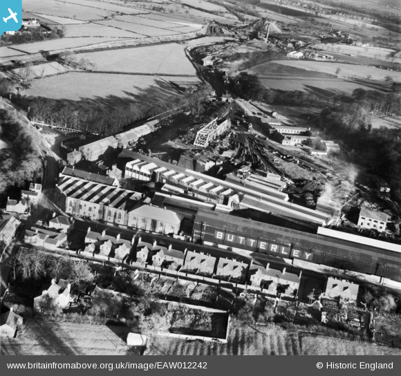
EAW012242 ENGLAND (1947). The Butterley Iron Works, Butterley, 1947
© Copyright OpenStreetMap contributors and licensed by the OpenStreetMap Foundation. 2026. Cartography is licensed as CC BY-SA.
Nearby Images (23)
EAW012242

EAW012243

EAW012257

EAW012260

EPW050252

EPW050254

EPW050251

EAW012247

EPW050255

EAW012258

EAW012244

EAW012246

EAW012264

EPW050253

EAW012245

EAW012263

EAW012259

EAW012256

EAW012262

EAW012254

EAW012249

EAW012250

EAW012251

Details
| Title | [EAW012242] The Butterley Iron Works, Butterley, 1947 |
| Reference | EAW012242 |
| Date | 24-November-1947 |
| Link | |
| Place name | BUTTERLEY |
| Parish | RIPLEY |
| District | |
| Country | ENGLAND |
| Easting / Northing | 440177, 351618 |
| Longitude / Latitude | -1.4004373465268, 53.059997185318 |
| National Grid Reference | SK402516 |
Pins

Andy |
Friday 21st of January 2022 01:57:20 AM | |
|
MB |
Sunday 3rd of November 2013 10:42:21 PM | |
|
MB |
Sunday 3rd of November 2013 10:41:24 PM | |
This is the former Midland Railway line that ran between Ambergate Junction and Pye Bridge Junction, closed as a through route in 1968, parts of the line form the present-day Midland Railway Centre heritage line that terminates at Hammersmith. |
Smudger |
Tuesday 10th of December 2013 05:08:15 PM |
|
MB |
Sunday 3rd of November 2013 10:40:34 PM | |
|
MB |
Sunday 3rd of November 2013 10:39:09 PM | |
|
MB |
Sunday 3rd of November 2013 10:38:49 PM | |

Maurice |
Sunday 3rd of November 2013 07:05:50 PM |