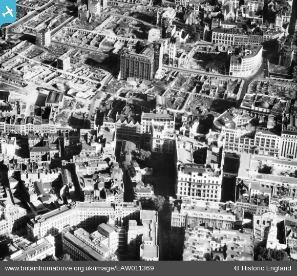
EAW011369 ENGLAND (1947). Bomb damaged and cleared areas on the east side of Aldersgate Street, London, 1947
    © Copyright OpenStreetMap contributors and licensed by the OpenStreetMap Foundation. 2025. Cartography is licensed as CC BY-SA.
  
Nearby Images (40)
Details
| Title | [EAW011369] Bomb damaged and cleared areas on the east side of Aldersgate Street, London, 1947 | 
| Reference | EAW011369 | 
| Date | 3-October-1947 | 
| Link | |
| Place name | LONDON | 
| Parish | |
| District | |
| Country | ENGLAND | 
| Easting / Northing | 532156, 181487 | 
| Longitude / Latitude | -0.095141368684148, 51.516344360107 | 
| National Grid Reference | TQ322815 | 
Pins
|  Firing range on the roof of Alder House. My office was under this in 1980's and I used the old range as a store. |   FramptonStreetBoy | Thursday 2nd of May 2024 11:41:34 PM | 
|  Aldermanbury |   Captaintee | Monday 18th of January 2021 01:58:06 PM | 
|  51-55 Gresham Street |   Hermann the German | Friday 25th of August 2017 05:49:22 PM | 
|  St Anne & St Agnes Church | Class31 | Thursday 12th of June 2014 10:39:55 AM | 
|  Gresham Street | Class31 | Thursday 12th of June 2014 10:38:21 AM | 
|  St Martin's le Grand | Class31 | Thursday 12th of June 2014 10:36:41 AM | 
|   Alan McFaden | Thursday 12th of December 2013 01:31:16 PM | |
|   Alan McFaden | Sunday 24th of November 2013 10:01:06 PM | |
|  St Mary, Aldermanbury
now in the USA |   Chelsea61 | Tuesday 5th of November 2013 07:26:50 PM | 
|  St Alban, Wood Street |   Chelsea61 | Tuesday 5th of November 2013 07:25:58 PM | 
User Comment Contributions
| View looking east. | Class31 | Thursday 12th of June 2014 10:37:04 AM | 
 
             
  ![[EAW011369] Bomb damaged and cleared areas on the east side of Aldersgate Street, London, 1947](http://britainfromabove.org.uk/sites/all/libraries/aerofilms-images/public/100x100/EAW/011/EAW011369.jpg) 
  
                                          ![[EPW028613] St Paul's Cathedral and environs, London, 1929](http://britainfromabove.org.uk/sites/all/libraries/aerofilms-images/public/100x100/EPW/028/EPW028613.jpg) 
 ![[EPW028615] St Paul's Cathedral and environs, London, 1929](http://britainfromabove.org.uk/sites/all/libraries/aerofilms-images/public/100x100/EPW/028/EPW028615.jpg) 
 ![[EPW062007] Aldersgate, London, 1939](http://britainfromabove.org.uk/sites/all/libraries/aerofilms-images/public/100x100/EPW/062/EPW062007.jpg) 
 ![[EPW062031] Aldersgate Street and environs, London, 1939](http://britainfromabove.org.uk/sites/all/libraries/aerofilms-images/public/100x100/EPW/062/EPW062031.jpg) 
 ![[EPW062011] Aldersgate Street, London, 1939](http://britainfromabove.org.uk/sites/all/libraries/aerofilms-images/public/100x100/EPW/062/EPW062011.jpg) 
 ![[EPW062008] Aldersgate, London, 1939](http://britainfromabove.org.uk/sites/all/libraries/aerofilms-images/public/100x100/EPW/062/EPW062008.jpg) 
 ![[EPW062010] St Bartholomew's Hospital and Aldersgate Street, London, 1939](http://britainfromabove.org.uk/sites/all/libraries/aerofilms-images/public/100x100/EPW/062/EPW062010.jpg) 
 ![[EPW028614] St Paul's Cathedral and environs, London, 1929](http://britainfromabove.org.uk/sites/all/libraries/aerofilms-images/public/100x100/EPW/028/EPW028614.jpg) 
 ![[EPW062009] St Bartholomew's Hospital and Aldersgate, London, 1939](http://britainfromabove.org.uk/sites/all/libraries/aerofilms-images/public/100x100/EPW/062/EPW062009.jpg) 
 ![[EAW011190] King Edward Street, St Bartholomew's Hospital and environs, London, 1947](http://britainfromabove.org.uk/sites/all/libraries/aerofilms-images/public/100x100/EAW/011/EAW011190.jpg) 
 ![[EPW028612] St Paul's Cathedral and environs, London, 1929](http://britainfromabove.org.uk/sites/all/libraries/aerofilms-images/public/100x100/EPW/028/EPW028612.jpg) 
 ![[EAW000506] St Paul's Cathedral and surrounding bomb damage and clearance, London, 1946](http://britainfromabove.org.uk/sites/all/libraries/aerofilms-images/public/100x100/EAW/000/EAW000506.jpg) 
 ![[EAW000508] St Paul's Cathedral and surrounding bomb damage and clearance, London, 1946](http://britainfromabove.org.uk/sites/all/libraries/aerofilms-images/public/100x100/EAW/000/EAW000508.jpg) 
 ![[EAW011191] Cleared sites around Wood Street and Jewin Crescent following bomb damage, London, 1947](http://britainfromabove.org.uk/sites/all/libraries/aerofilms-images/public/100x100/EAW/011/EAW011191.jpg) 
 ![[EAW020403] St Paul's Cathedral and environs, London, 1948](http://britainfromabove.org.uk/sites/all/libraries/aerofilms-images/public/100x100/EAW/020/EAW020403.jpg) 
 ![[EPW028616] St Paul's Cathedral and environs, London, 1929](http://britainfromabove.org.uk/sites/all/libraries/aerofilms-images/public/100x100/EPW/028/EPW028616.jpg) 
 ![[EAW018351] St Paul's Cathedral and surrounding bomb damaged area, London, 1948. This image has been produced from a print.](http://britainfromabove.org.uk/sites/all/libraries/aerofilms-images/public/100x100/EAW/018/EAW018351.jpg) 
 ![[EPW055300] The area between St Martin's Le Grand and Bunhill Row, London, from the south, 1937](http://britainfromabove.org.uk/sites/all/libraries/aerofilms-images/public/100x100/EPW/055/EPW055300.jpg) 
 ![[EPW009002] St Paul's Cathedral, Wood Street and environs, London, 1923](http://britainfromabove.org.uk/sites/all/libraries/aerofilms-images/public/100x100/EPW/009/EPW009002.jpg) 
 ![[EAW011368] Bomb damaged and cleared areas around Jewin Crescent (the site of the Barbican Centre), London, 1947](http://britainfromabove.org.uk/sites/all/libraries/aerofilms-images/public/100x100/EAW/011/EAW011368.jpg) 
 ![[EAW011370] Bomb damaged and cleared areas to the north-east of St Paul's Cathedral, London, 1947](http://britainfromabove.org.uk/sites/all/libraries/aerofilms-images/public/100x100/EAW/011/EAW011370.jpg) 
 ![[EPW045610] The River Thames and the city from Blackfriars Bridge to London Bridge, London, from the north, 1934](http://britainfromabove.org.uk/sites/all/libraries/aerofilms-images/public/100x100/EPW/045/EPW045610.jpg) 
 ![[EAW053007] St Paul's Cathedral, surrounding cleared areas and environs, London, 1953](http://britainfromabove.org.uk/sites/all/libraries/aerofilms-images/public/100x100/EAW/053/EAW053007.jpg) 
 ![[EAW021119] A cityscape over the River Thames, London, 1949. This image has been produced from a print.](http://britainfromabove.org.uk/sites/all/libraries/aerofilms-images/public/100x100/EAW/021/EAW021119.jpg) 
 ![[EPW009001] Wood Street and environs, London, 1923](http://britainfromabove.org.uk/sites/all/libraries/aerofilms-images/public/100x100/EPW/009/EPW009001.jpg) 
 ![[EPW009004] Gresham Street and environs, London, 1923](http://britainfromabove.org.uk/sites/all/libraries/aerofilms-images/public/100x100/EPW/009/EPW009004.jpg) 
 ![[EAW011115] Cleared sites around Wood Street following bomb damage, London, 1947](http://britainfromabove.org.uk/sites/all/libraries/aerofilms-images/public/100x100/EAW/011/EAW011115.jpg) 
 ![[EAW053010] St Paul's Cathedral, surrounding cleared areas and environs, London, 1953](http://britainfromabove.org.uk/sites/all/libraries/aerofilms-images/public/100x100/EAW/053/EAW053010.jpg) 
 ![[EPW011928] St Paul's Cathedral and environs, London, 1924. This image has been produced from a print.](http://britainfromabove.org.uk/sites/all/libraries/aerofilms-images/public/100x100/EPW/011/EPW011928.jpg) 
 ![[EPW055311] Cheapside, Cannon Street and environs, London, from the south-east, 1937](http://britainfromabove.org.uk/sites/all/libraries/aerofilms-images/public/100x100/EPW/055/EPW055311.jpg) 
 ![[EPW009005] Wood Street and environs, London, 1923](http://britainfromabove.org.uk/sites/all/libraries/aerofilms-images/public/100x100/EPW/009/EPW009005.jpg) 
 ![[EPW056674] St Paul's Cathedral and the City, London, 1938](http://britainfromabove.org.uk/sites/all/libraries/aerofilms-images/public/100x100/EPW/056/EPW056674.jpg) 
 ![[EPW009000] Wood Street and environs, London, 1923](http://britainfromabove.org.uk/sites/all/libraries/aerofilms-images/public/100x100/EPW/009/EPW009000.jpg) 
 ![[EPW009003] Wood Street and environs, London, 1923](http://britainfromabove.org.uk/sites/all/libraries/aerofilms-images/public/100x100/EPW/009/EPW009003.jpg) 
 ![[EAW000660] St Paul's Cathedral and the surrounding bomb damaged area, London, 1946](http://britainfromabove.org.uk/sites/all/libraries/aerofilms-images/public/100x100/EAW/000/EAW000660.jpg) 
 ![[EAW049465] Smithfield Market (London Central Markets) looking towards St Paul's Cathedral and the River Thames, London, 1953](http://britainfromabove.org.uk/sites/all/libraries/aerofilms-images/public/100x100/EAW/049/EAW049465.jpg) 
 ![[EAW053004] St Paul's Cathedral and environs, London, 1953](http://britainfromabove.org.uk/sites/all/libraries/aerofilms-images/public/100x100/EAW/053/EAW053004.jpg) 
 ![[EAW011114] Cleared site by Goldsmiths' Hall following bomb damage and the area around Cheapside and Gresham Street, London, 1947](http://britainfromabove.org.uk/sites/all/libraries/aerofilms-images/public/100x100/EAW/011/EAW011114.jpg) 
 ![[EAW000513] Bomb damage and clearance around Moorgate Street Station, London, 1946](http://britainfromabove.org.uk/sites/all/libraries/aerofilms-images/public/100x100/EAW/000/EAW000513.jpg) 
 
