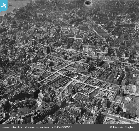
EAW000513 ENGLAND (1946). Bomb damage and clearance around Moorgate Street Station, London, 1946
    © Copyright OpenStreetMap contributors and licensed by the OpenStreetMap Foundation. 2025. Cartography is licensed as CC BY-SA.
  
Nearby Images (19)
Details
| Title | [EAW000513] Bomb damage and clearance around Moorgate Street Station, London, 1946 | 
| Reference | EAW000513 | 
| Date | 9-May-1946 | 
| Link | |
| Place name | LONDON | 
| Parish | |
| District | |
| Country | ENGLAND | 
| Easting / Northing | 532401, 181664 | 
| Longitude / Latitude | -0.091545608932785, 51.517877766774 | 
| National Grid Reference | TQ324817 | 
Pins
|  Whitbread's; Brewery, Chiswell Street |   APR | Tuesday 11th of June 2024 07:33:21 PM | 
|  Tower of the church of St Mary Aldermanbury |   RW | Tuesday 6th of December 2022 05:52:45 PM | 
|  Tower of the church of St Alban, Wood Street |   RW | Tuesday 6th of December 2022 05:52:01 PM | 
|  Whitecross Street |   brianbeckett | Tuesday 28th of April 2020 02:54:32 PM | 
|  Goldsmiths' Hall | Class31 | Wednesday 6th of August 2014 03:46:47 PM | 
|  Bunhill Fields | Class31 | Wednesday 6th of August 2014 03:46:14 PM | 
|  Bunhill Row | Class31 | Wednesday 6th of August 2014 03:45:53 PM | 
|  London Wall | Class31 | Thursday 12th of June 2014 11:31:08 PM | 
|   Alan McFaden | Friday 23rd of May 2014 10:29:30 AM | |
|   Alan McFaden | Friday 23rd of May 2014 10:28:30 AM | |
| Class31 | Tuesday 13th of May 2014 03:17:17 PM | |
|  Moorgate | Class31 | Tuesday 13th of May 2014 03:14:52 PM | 
|  Moorgate Railway Station | Class31 | Tuesday 13th of May 2014 03:14:32 PM | 
|   Alan McFaden | Friday 21st of March 2014 09:57:01 AM | |
|  Finsbury Circus |   S00Z | Monday 4th of November 2013 10:15:35 PM | 
|   Alan McFaden | Saturday 12th of October 2013 10:17:20 AM | |
|   Alan McFaden | Saturday 12th of October 2013 10:15:56 AM | |
|   Alan McFaden | Saturday 12th of October 2013 10:15:15 AM | |
|   Alan McFaden | Saturday 12th of October 2013 10:10:56 AM | |
|   Alan McFaden | Saturday 12th of October 2013 10:08:59 AM | |
|   Alan McFaden | Saturday 12th of October 2013 10:07:50 AM | |
|   Alan McFaden | Saturday 12th of October 2013 10:03:32 AM | |
|   Alan McFaden | Saturday 12th of October 2013 10:02:26 AM | |
|   Alan McFaden | Saturday 12th of October 2013 10:00:07 AM | |
|   Alan McFaden | Saturday 12th of October 2013 09:58:34 AM | |
|   Alan McFaden | Saturday 12th of October 2013 09:57:23 AM | |
|   Alan McFaden | Saturday 12th of October 2013 09:55:27 AM | |
|   Alan McFaden | Saturday 12th of October 2013 09:52:09 AM | |
|   Alan McFaden | Saturday 12th of October 2013 09:50:31 AM | |
|   Alan McFaden | Saturday 12th of October 2013 09:49:19 AM | |
|   Alan McFaden | Saturday 12th of October 2013 09:48:25 AM | 
 
             
  ![[EAW000513] Bomb damage and clearance around Moorgate Street Station, London, 1946](http://britainfromabove.org.uk/sites/all/libraries/aerofilms-images/public/100x100/EAW/000/EAW000513.jpg) 
  
                                          ![[EAW000511] Bomb damage and clearance around Moorgate Street Station, London, 1946](http://britainfromabove.org.uk/sites/all/libraries/aerofilms-images/public/100x100/EAW/000/EAW000511.jpg) 
 ![[EAW011116] Cleared sites around Moorgate Street Station and Jewin Crescent following bomb damage, London, 1947](http://britainfromabove.org.uk/sites/all/libraries/aerofilms-images/public/100x100/EAW/011/EAW011116.jpg) 
 ![[EPW055300] The area between St Martin's Le Grand and Bunhill Row, London, from the south, 1937](http://britainfromabove.org.uk/sites/all/libraries/aerofilms-images/public/100x100/EPW/055/EPW055300.jpg) 
 ![[EAW049464] The bomb-damaged Cripplegate area (site of The Barbican Centre), London, 1953](http://britainfromabove.org.uk/sites/all/libraries/aerofilms-images/public/100x100/EAW/049/EAW049464.jpg) 
 ![[EAW026314] Finsbury Circus, Liverpool Street Station and the City of London, London, from the west, 1949](http://britainfromabove.org.uk/sites/all/libraries/aerofilms-images/public/100x100/EAW/026/EAW026314.jpg) 
 ![[EAW026313] Finsbury Circus, Liverpool Street Station and the City of London, London, from the west, 1949](http://britainfromabove.org.uk/sites/all/libraries/aerofilms-images/public/100x100/EAW/026/EAW026313.jpg) 
 ![[EAW011115] Cleared sites around Wood Street following bomb damage, London, 1947](http://britainfromabove.org.uk/sites/all/libraries/aerofilms-images/public/100x100/EAW/011/EAW011115.jpg) 
 ![[EAW011191] Cleared sites around Wood Street and Jewin Crescent following bomb damage, London, 1947](http://britainfromabove.org.uk/sites/all/libraries/aerofilms-images/public/100x100/EAW/011/EAW011191.jpg) 
 ![[EAW011368] Bomb damaged and cleared areas around Jewin Crescent (the site of the Barbican Centre), London, 1947](http://britainfromabove.org.uk/sites/all/libraries/aerofilms-images/public/100x100/EAW/011/EAW011368.jpg) 
 ![[EPW062008] Aldersgate, London, 1939](http://britainfromabove.org.uk/sites/all/libraries/aerofilms-images/public/100x100/EPW/062/EPW062008.jpg) 
 ![[EAW011367] Bomb damaged and cleared areas around Red Cross Street (the site of the Barbican Centre), London, 1947](http://britainfromabove.org.uk/sites/all/libraries/aerofilms-images/public/100x100/EAW/011/EAW011367.jpg) 
 ![[EAW021730] A cityscape over central London, London, 1949. This image has been produced from a print.](http://britainfromabove.org.uk/sites/all/libraries/aerofilms-images/public/100x100/EAW/021/EAW021730.jpg) 
 ![[EPW028614] St Paul's Cathedral and environs, London, 1929](http://britainfromabove.org.uk/sites/all/libraries/aerofilms-images/public/100x100/EPW/028/EPW028614.jpg) 
 ![[EPW028613] St Paul's Cathedral and environs, London, 1929](http://britainfromabove.org.uk/sites/all/libraries/aerofilms-images/public/100x100/EPW/028/EPW028613.jpg) 
 ![[EAW011192] Coleman Street and cleared areas around Moorgate Street Station following bomb damage, London, 1947](http://britainfromabove.org.uk/sites/all/libraries/aerofilms-images/public/100x100/EAW/011/EAW011192.jpg) 
 ![[EAW011369] Bomb damaged and cleared areas on the east side of Aldersgate Street, London, 1947](http://britainfromabove.org.uk/sites/all/libraries/aerofilms-images/public/100x100/EAW/011/EAW011369.jpg) 
 ![[EAW000514] Bomb damage and clearance around Moorgate Street Station, the Artillery Ground and environs, London, 1946](http://britainfromabove.org.uk/sites/all/libraries/aerofilms-images/public/100x100/EAW/000/EAW000514.jpg) 
 ![[EPW028615] St Paul's Cathedral and environs, London, 1929](http://britainfromabove.org.uk/sites/all/libraries/aerofilms-images/public/100x100/EPW/028/EPW028615.jpg) 


