
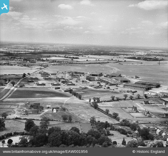
EAW001956 ENGLAND (1946). RAF Horsham St Faith, Norwich, from the east, 1946. This image has been produced from a damaged negative.
© Copyright OpenStreetMap contributors and licensed by the OpenStreetMap Foundation. 2026. Cartography is licensed as CC BY-SA.
Nearby Images (6)
EAW001956

EAW001957

EAW002909

EAW002906

EAW002910

EAW002905

Details
| Title | [EAW001956] RAF Horsham St Faith, Norwich, from the east, 1946. This image has been produced from a damaged negative. |
| Reference | EAW001956 |
| Date | 25-July-1946 |
| Link | |
| Place name | NORWICH |
| Parish | |
| District | |
| Country | ENGLAND |
| Easting / Northing | 622673, 312672 |
| Longitude / Latitude | 1.293424208552, 52.665596917823 |
| National Grid Reference | TG227127 |
Pins

redmist |
Tuesday 23rd of November 2021 06:57:28 PM | |

Matt Aldred edob.mattaldred.com |
Tuesday 24th of November 2020 10:17:42 PM | |
|
Matt Aldred edob.mattaldred.com |
Tuesday 24th of November 2020 10:17:27 PM | |
|
Matt Aldred edob.mattaldred.com |
Tuesday 24th of November 2020 10:17:07 PM | |
|
Matt Aldred edob.mattaldred.com |
Tuesday 24th of November 2020 10:16:53 PM | |
|
Matt Aldred edob.mattaldred.com |
Tuesday 24th of November 2020 10:16:39 PM | |
|
sum0 |
Wednesday 15th of April 2020 09:34:22 PM | |
|
sum0 |
Wednesday 15th of April 2020 09:33:57 PM | |
|
gBr |
Saturday 28th of November 2015 05:44:44 PM |