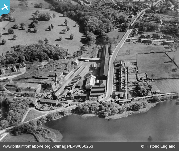
EPW050253 ENGLAND (1936). The Butterley Co Iron Works, Butterley, 1936
© Copyright OpenStreetMap contributors and licensed by the OpenStreetMap Foundation. 2024. Cartography is licensed as CC BY-SA.
Nearby Images (27)
Details
| Title | [EPW050253] The Butterley Co Iron Works, Butterley, 1936 |
| Reference | EPW050253 |
| Date | May-1936 |
| Link | |
| Place name | BUTTERLEY |
| Parish | RIPLEY |
| District | |
| Country | ENGLAND |
| Easting / Northing | 440116, 351530 |
| Longitude / Latitude | -1.4013585634779, 53.059210680463 |
| National Grid Reference | SK401515 |
Pins
 gellert |
Thursday 20th of February 2014 06:23:01 PM |


![[EPW050253] The Butterley Co Iron Works, Butterley, 1936](http://britainfromabove.org.uk/sites/all/libraries/aerofilms-images/public/100x100/EPW/050/EPW050253.jpg)
![[EPW050251] The Butterley Co Iron Works, Butterley, 1936](http://britainfromabove.org.uk/sites/all/libraries/aerofilms-images/public/100x100/EPW/050/EPW050251.jpg)
![[EPW050254] The Butterley Co Iron Works, Butterley, 1936](http://britainfromabove.org.uk/sites/all/libraries/aerofilms-images/public/100x100/EPW/050/EPW050254.jpg)
![[EPW050252] The Butterley Co Iron Works, Butterley, 1936](http://britainfromabove.org.uk/sites/all/libraries/aerofilms-images/public/100x100/EPW/050/EPW050252.jpg)
![[EAW012259] The Butterley Iron Works and environs, Butterley, from the south, 1947](http://britainfromabove.org.uk/sites/all/libraries/aerofilms-images/public/100x100/EAW/012/EAW012259.jpg)
![[EPW050255] The Butterley Co Iron Works, Butterley, 1936](http://britainfromabove.org.uk/sites/all/libraries/aerofilms-images/public/100x100/EPW/050/EPW050255.jpg)
![[EAW012242] The Butterley Iron Works, Butterley, 1947](http://britainfromabove.org.uk/sites/all/libraries/aerofilms-images/public/100x100/EAW/012/EAW012242.jpg)
![[EAW012243] The Butterley Iron Works, Butterley, 1947](http://britainfromabove.org.uk/sites/all/libraries/aerofilms-images/public/100x100/EAW/012/EAW012243.jpg)
![[EAW012257] The Butterley Iron Works, Butterley, 1947. This image was marked by Aerofilms Ltd for photo editing.](http://britainfromabove.org.uk/sites/all/libraries/aerofilms-images/public/100x100/EAW/012/EAW012257.jpg)
![[EAW012251] The Butterley Iron Works and environs, Butterley, from the south-west, 1947. This image was marked by Aerofilms Ltd for photo editing.](http://britainfromabove.org.uk/sites/all/libraries/aerofilms-images/public/100x100/EAW/012/EAW012251.jpg)
![[EAW012249] The Butterley Iron Works and environs, Butterley, from the west, 1947. This image was marked by Aerofilms Ltd for photo editing.](http://britainfromabove.org.uk/sites/all/libraries/aerofilms-images/public/100x100/EAW/012/EAW012249.jpg)
![[EAW012254] The Butterley Iron Works and environs, Butterley, from the north-west, 1947. This image was marked by Aerofilms Ltd for photo editing.](http://britainfromabove.org.uk/sites/all/libraries/aerofilms-images/public/100x100/EAW/012/EAW012254.jpg)
![[EAW012260] The Butterley Iron Works and environs, Butterley, 1947](http://britainfromabove.org.uk/sites/all/libraries/aerofilms-images/public/100x100/EAW/012/EAW012260.jpg)
![[EAW012250] The Butterley Iron Works and environs, Butterley, from the north-west, 1947](http://britainfromabove.org.uk/sites/all/libraries/aerofilms-images/public/100x100/EAW/012/EAW012250.jpg)
![[EAW012258] The Butterley Iron Works, Butterley, 1947](http://britainfromabove.org.uk/sites/all/libraries/aerofilms-images/public/100x100/EAW/012/EAW012258.jpg)
![[EAW012247] Project under construction at the Butterley Iron Works, Butterley, 1947](http://britainfromabove.org.uk/sites/all/libraries/aerofilms-images/public/100x100/EAW/012/EAW012247.jpg)
![[EAW012263] The Butterley Iron Works, Butterley, 1947. This image has been produced from a damaged negative.](http://britainfromabove.org.uk/sites/all/libraries/aerofilms-images/public/100x100/EAW/012/EAW012263.jpg)
![[EAW012264] The Butterley Iron Works, Butterley, 1947. This image has been produced from a print marked by Aerofilms Ltd for photo-editing.](http://britainfromabove.org.uk/sites/all/libraries/aerofilms-images/public/100x100/EAW/012/EAW012264.jpg)
![[EAW012244] Project under construction at the Butterley Iron Works, Butterley, 1947](http://britainfromabove.org.uk/sites/all/libraries/aerofilms-images/public/100x100/EAW/012/EAW012244.jpg)
![[EAW012246] Project under construction at the Butterley Iron Works, Butterley, 1947](http://britainfromabove.org.uk/sites/all/libraries/aerofilms-images/public/100x100/EAW/012/EAW012246.jpg)
![[EAW012245] Project under construction at the Butterley Iron Works, Butterley, 1947](http://britainfromabove.org.uk/sites/all/libraries/aerofilms-images/public/100x100/EAW/012/EAW012245.jpg)
![[EAW012256] The Butterley Iron Works and environs, Butterley, from the north-west, 1947](http://britainfromabove.org.uk/sites/all/libraries/aerofilms-images/public/100x100/EAW/012/EAW012256.jpg)
![[EAW012262] The Butterley Iron Works and environs, Butterley, from the north-west, 1947. This image has been produced from a damaged negative.](http://britainfromabove.org.uk/sites/all/libraries/aerofilms-images/public/100x100/EAW/012/EAW012262.jpg)
![[EAW012252] The Butterley Iron Works and environs, Butterley, from the west, 1947. This image was marked by Aerofilms Ltd for photo editing.](http://britainfromabove.org.uk/sites/all/libraries/aerofilms-images/public/100x100/EAW/012/EAW012252.jpg)
![[EAW012253] The Butterley Iron Works and environs, Butterley, from the west, 1947. This image was marked by Aerofilms Ltd for photo editing.](http://britainfromabove.org.uk/sites/all/libraries/aerofilms-images/public/100x100/EAW/012/EAW012253.jpg)
![[EAW012261] The Butterley Iron Works and environs, Butterley, from the west, 1947. This image was marked by Aerofilms Ltd for photo editing.](http://britainfromabove.org.uk/sites/all/libraries/aerofilms-images/public/100x100/EAW/012/EAW012261.jpg)
![[EAW012255] The Butterley Iron Works and environs, Butterley, from the north-west, 1947. This image was marked by Aerofilms Ltd for photo editing.](http://britainfromabove.org.uk/sites/all/libraries/aerofilms-images/public/100x100/EAW/012/EAW012255.jpg)


