
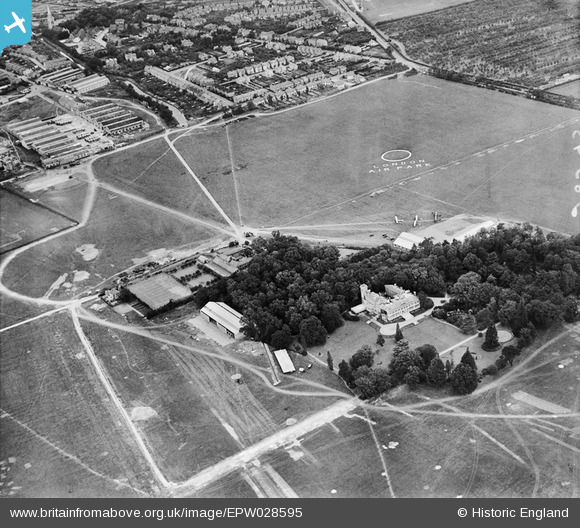
EPW028595 ENGLAND (1929). Hanworth Park Aerodrome (London Air Park) and Hanworth Park House, Hanworth Park, 1929
© Copyright OpenStreetMap contributors and licensed by the OpenStreetMap Foundation. 2024. Cartography is licensed as CC BY-SA.
Nearby Images (26)
EPW028595
 and Hanworth Park House, Hanworth Park, 1929")
EPW026140
, Hanworth Park, 1929")
EPW026133
, Hanworth Park, 1929")
EPW036237

EPW026134
, Hanworth Park, 1929")
EPW026136
 and Hanworth Park House, Hanworth Park, 1929")
EPW026132

EPW025759

EPW025754

EPW025757

EPW036244

EPW026139

EPW026135
 and Hanworth Park House, Hanworth Park, 1929")
EPW025758

EPW028594
 and Hanworth Park House, Hanworth Park, 1929")
EPW025751
, Hanworth Park, 1929")
EPW036240

EPW026131

EPW038817
 moored at Hanworth Aerodrome (London Air Park), from the south-east, 1932")
EPW036239

EPW026130
, Hanworth Park, 1929")
EPW036238

EPW036234

EPW036235

EPW036243

EPW037354

Details
| Title | [EPW028595] Hanworth Park Aerodrome (London Air Park) and Hanworth Park House, Hanworth Park, 1929 |
| Reference | EPW028595 |
| Date | August-1929 |
| Link | |
| Place name | HANWORTH PARK |
| Parish | |
| District | |
| Country | ENGLAND |
| Easting / Northing | 511288, 172490 |
| Longitude / Latitude | -0.39862356858977, 51.439967880085 |
| National Grid Reference | TQ113725 |
Pins
Be the first to add a comment to this image!


