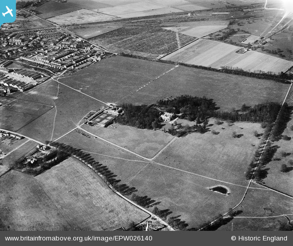
EPW026140 ENGLAND (1929). Hanworth Park House and Aerodrome (London Air Park), Hanworth Park, 1929
© Copyright OpenStreetMap contributors and licensed by the OpenStreetMap Foundation. 2024. Cartography is licensed as CC BY-SA.
Nearby Images (23)
Details
| Title | [EPW026140] Hanworth Park House and Aerodrome (London Air Park), Hanworth Park, 1929 |
| Reference | EPW026140 |
| Date | 22-April-1929 |
| Link | |
| Place name | HANWORTH PARK |
| Parish | |
| District | |
| Country | ENGLAND |
| Easting / Northing | 511305, 172443 |
| Longitude / Latitude | -0.39839383061475, 51.439542052285 |
| National Grid Reference | TQ113724 |
Pins
 bumblee |
Saturday 6th of December 2014 06:44:09 PM |


![[EPW026140] Hanworth Park House and Aerodrome (London Air Park), Hanworth Park, 1929](http://britainfromabove.org.uk/sites/all/libraries/aerofilms-images/public/100x100/EPW/026/EPW026140.jpg)
![[EPW028595] Hanworth Park Aerodrome (London Air Park) and Hanworth Park House, Hanworth Park, 1929](http://britainfromabove.org.uk/sites/all/libraries/aerofilms-images/public/100x100/EPW/028/EPW028595.jpg)
![[EPW026136] Hanworth Park Aerodrome (London Air Park) and Hanworth Park House, Hanworth Park, 1929](http://britainfromabove.org.uk/sites/all/libraries/aerofilms-images/public/100x100/EPW/026/EPW026136.jpg)
![[EPW026132] Hanworth Park House, Hanworth Park, 1929](http://britainfromabove.org.uk/sites/all/libraries/aerofilms-images/public/100x100/EPW/026/EPW026132.jpg)
![[EPW025757] Hanworth Park House, Hanworth Park, 1929. This image has been produced from a copy-negative.](http://britainfromabove.org.uk/sites/all/libraries/aerofilms-images/public/100x100/EPW/025/EPW025757.jpg)
![[EPW025759] Hanworth Park House, Hanworth Park, 1929](http://britainfromabove.org.uk/sites/all/libraries/aerofilms-images/public/100x100/EPW/025/EPW025759.jpg)
![[EPW025754] Hanworth Park House, Hanworth Park, 1929](http://britainfromabove.org.uk/sites/all/libraries/aerofilms-images/public/100x100/EPW/025/EPW025754.jpg)
![[EPW026139] Hanworth Park House, Hanworth Park, 1929](http://britainfromabove.org.uk/sites/all/libraries/aerofilms-images/public/100x100/EPW/026/EPW026139.jpg)
![[EPW026135] Hanworth Park Aerodrome (London Air Park) and Hanworth Park House, Hanworth Park, 1929](http://britainfromabove.org.uk/sites/all/libraries/aerofilms-images/public/100x100/EPW/026/EPW026135.jpg)
![[EPW025758] Hanworth Park House, Hanworth Park, 1929](http://britainfromabove.org.uk/sites/all/libraries/aerofilms-images/public/100x100/EPW/025/EPW025758.jpg)
![[EPW025751] Hanworth Park House and Aerodrome (London Air Park), Hanworth Park, 1929](http://britainfromabove.org.uk/sites/all/libraries/aerofilms-images/public/100x100/EPW/025/EPW025751.jpg)
![[EPW026131] Hanworth Park House, Hanworth Park, 1929](http://britainfromabove.org.uk/sites/all/libraries/aerofilms-images/public/100x100/EPW/026/EPW026131.jpg)
![[EPW026134] Hanworth Park Aerodrome (London Air Park), Hanworth Park, 1929](http://britainfromabove.org.uk/sites/all/libraries/aerofilms-images/public/100x100/EPW/026/EPW026134.jpg)
![[EPW026133] Hanworth Park Aerodrome (London Air Park), Hanworth Park, 1929](http://britainfromabove.org.uk/sites/all/libraries/aerofilms-images/public/100x100/EPW/026/EPW026133.jpg)
![[EPW028594] Hanworth Park Aerodrome (London Air Park) and Hanworth Park House, Hanworth Park, 1929](http://britainfromabove.org.uk/sites/all/libraries/aerofilms-images/public/100x100/EPW/028/EPW028594.jpg)
![[EPW036237] Hanworth Park, the D-LZ 127 Graf Zeppelin moored at London Air Park after completing a 24-hour round-Britain passenger tour, 1931. This image has been produced from a damaged negative.](http://britainfromabove.org.uk/sites/all/libraries/aerofilms-images/public/100x100/EPW/036/EPW036237.jpg)
![[EPW036244] Hanworth Park, the D-LZ 127 Graf Zeppelin moored at London Air Park after completing a 24-hour round-Britain passenger tour, 1931. This image has been produced from a damaged negative.](http://britainfromabove.org.uk/sites/all/libraries/aerofilms-images/public/100x100/EPW/036/EPW036244.jpg)
![[EPW026130] Hanworth Park Aerodrome (London Air Park), Hanworth Park, 1929](http://britainfromabove.org.uk/sites/all/libraries/aerofilms-images/public/100x100/EPW/026/EPW026130.jpg)
![[EPW036240] Hanworth Park, the D-LZ 127 Graf Zeppelin moored at London Air Park after completing a 24-hour round-Britain passenger tour, 1931. This image has been produced from a damaged negative.](http://britainfromabove.org.uk/sites/all/libraries/aerofilms-images/public/100x100/EPW/036/EPW036240.jpg)
![[EPW038817] Hanworth, The Graf Zeppelin (D-LZ127) moored at Hanworth Aerodrome (London Air Park), from the south-east, 1932](http://britainfromabove.org.uk/sites/all/libraries/aerofilms-images/public/100x100/EPW/038/EPW038817.jpg)
![[EPW028596] Hanworth Park Aerodrome (London Air Park) and environs, Hanworth Park, 1929](http://britainfromabove.org.uk/sites/all/libraries/aerofilms-images/public/100x100/EPW/028/EPW028596.jpg)
![[EPW036239] Hanworth Park, the D-LZ 127 Graf Zeppelin moored at London Air Park after completing a 24-hour round-Britain passenger tour, 1931. This image has been produced from a damaged negative.](http://britainfromabove.org.uk/sites/all/libraries/aerofilms-images/public/100x100/EPW/036/EPW036239.jpg)
![[EPW036238] Hanworth Park, the D-LZ 127 Graf Zeppelin moored at London Air Park after completing a 24-hour round-Britain passenger tour, 1931. This image has been produced from a damaged negative.](http://britainfromabove.org.uk/sites/all/libraries/aerofilms-images/public/100x100/EPW/036/EPW036238.jpg)


