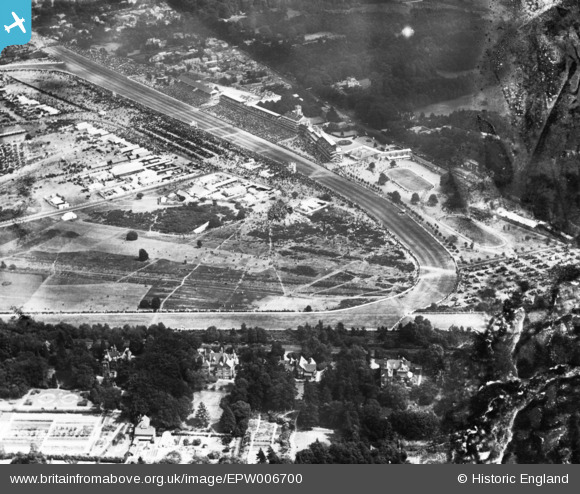
EPW006700 ENGLAND (1921). Ascot, Royal Ascot, 1921. This image has been produced from a damaged print.
© Copyright OpenStreetMap contributors and licensed by the OpenStreetMap Foundation. 2024. Cartography is licensed as CC BY-SA.
Nearby Images (24)
Details
| Title | [EPW006700] Ascot, Royal Ascot, 1921. This image has been produced from a damaged print. |
| Reference | EPW006700 |
| Date | June-1921 |
| Link | |
| Place name | ASCOT |
| Parish | SUNNINGHILL AND ASCOT |
| District | |
| Country | ENGLAND |
| Easting / Northing | 491790, 169163 |
| Longitude / Latitude | -0.67996328547996, 51.413553548875 |
| National Grid Reference | SU918692 |
Pins
Be the first to add a comment to this image!


![[EPW006700] Ascot, Royal Ascot, 1921. This image has been produced from a damaged print.](http://britainfromabove.org.uk/sites/all/libraries/aerofilms-images/public/100x100/EPW/006/EPW006700.jpg)
![[EAW022114] Ascot Racecourse, Ascot, from the west, 1949](http://britainfromabove.org.uk/sites/all/libraries/aerofilms-images/public/100x100/EAW/022/EAW022114.jpg)
![[EAW022115] Ascot Racecourse, Ascot, from the west, 1949](http://britainfromabove.org.uk/sites/all/libraries/aerofilms-images/public/100x100/EAW/022/EAW022115.jpg)
![[EPW006708] Ascot, Royal Ascot, 1921. This image has been produced from a print.](http://britainfromabove.org.uk/sites/all/libraries/aerofilms-images/public/100x100/EPW/006/EPW006708.jpg)
![[EPW006702] Ascot, Royal Ascot, 1921](http://britainfromabove.org.uk/sites/all/libraries/aerofilms-images/public/100x100/EPW/006/EPW006702.jpg)
![[EAW042137] Ascot Racecourse in the snow, Ascot, 1952](http://britainfromabove.org.uk/sites/all/libraries/aerofilms-images/public/100x100/EAW/042/EAW042137.jpg)
![[EAW022117] Ascot Racecourse, Ascot, from the west, 1949](http://britainfromabove.org.uk/sites/all/libraries/aerofilms-images/public/100x100/EAW/022/EAW022117.jpg)
![[EPW013401] Ascot, Royal Ascot, 1925](http://britainfromabove.org.uk/sites/all/libraries/aerofilms-images/public/100x100/EPW/013/EPW013401.jpg)
![[EPW006707] Ascot, Royal Ascot, 1921. This image has been produced from a damaged print.](http://britainfromabove.org.uk/sites/all/libraries/aerofilms-images/public/100x100/EPW/006/EPW006707.jpg)
![[EPW026284] Ascot Racecourse home straight, grandstands and paddocks, Ascot, 1929](http://britainfromabove.org.uk/sites/all/libraries/aerofilms-images/public/100x100/EPW/026/EPW026284.jpg)
![[EAW026661] The Racecourse, Ascot, from the north-west, 1949](http://britainfromabove.org.uk/sites/all/libraries/aerofilms-images/public/100x100/EAW/026/EAW026661.jpg)
![[EPW013441] Ascot, Royal Ascot, 1925. This image has been produced from a print.](http://britainfromabove.org.uk/sites/all/libraries/aerofilms-images/public/100x100/EPW/013/EPW013441.jpg)
![[EPW008715] The Racecourse, Parade Ring and Royal Enclosure, Ascot, 1923](http://britainfromabove.org.uk/sites/all/libraries/aerofilms-images/public/100x100/EPW/008/EPW008715.jpg)
![[EPW006706] Ascot, Royal Ascot, 1921. This image has been produced from a damaged print.](http://britainfromabove.org.uk/sites/all/libraries/aerofilms-images/public/100x100/EPW/006/EPW006706.jpg)
![[EPW008705] The Grandstand and Royal Enclosure, Ascot, 1923](http://britainfromabove.org.uk/sites/all/libraries/aerofilms-images/public/100x100/EPW/008/EPW008705.jpg)
![[EPW008716] The Parade Ring, Ascot, 1923](http://britainfromabove.org.uk/sites/all/libraries/aerofilms-images/public/100x100/EPW/008/EPW008716.jpg)
![[EPW008709] The Racecourse, Ascot, 1923](http://britainfromabove.org.uk/sites/all/libraries/aerofilms-images/public/100x100/EPW/008/EPW008709.jpg)
![[EPW008710] The Racecourse (Swinley), Ascot, 1923](http://britainfromabove.org.uk/sites/all/libraries/aerofilms-images/public/100x100/EPW/008/EPW008710.jpg)
![[EPW036160] Ascot Racecourse home straight and grandstands, Ascot, 1931](http://britainfromabove.org.uk/sites/all/libraries/aerofilms-images/public/100x100/EPW/036/EPW036160.jpg)
![[EPW008704] Ascot, possibly the Ascot Gold Cup, 1923](http://britainfromabove.org.uk/sites/all/libraries/aerofilms-images/public/100x100/EPW/008/EPW008704.jpg)
![[EPW026285] Ascot Racecourse Royal Enclosure and grandstands, Ascot, 1929](http://britainfromabove.org.uk/sites/all/libraries/aerofilms-images/public/100x100/EPW/026/EPW026285.jpg)
![[EPW026290] Ascot Racecourse Royal Enclosure and grandstands, Ascot, 1929](http://britainfromabove.org.uk/sites/all/libraries/aerofilms-images/public/100x100/EPW/026/EPW026290.jpg)
![[EPW008714] The Racecourse, Pre-Parade and Parade Rings, Ascot, 1923](http://britainfromabove.org.uk/sites/all/libraries/aerofilms-images/public/100x100/EPW/008/EPW008714.jpg)
![[EPW013406] Ascot, Royal Ascot, 1925](http://britainfromabove.org.uk/sites/all/libraries/aerofilms-images/public/100x100/EPW/013/EPW013406.jpg)


